Leandro Canyon Topo Map New Mexico
To zoom in, hover over the map of Leandro Canyon
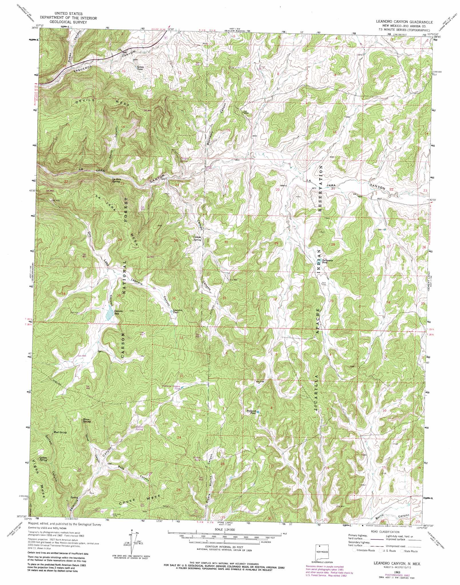
USGS Topo Quad 36107f2 - 1:24,000 scale
| Topo Map Name: | Leandro Canyon |
| USGS Topo Quad ID: | 36107f2 |
| Print Size: | ca. 21 1/4" wide x 27" high |
| Southeast Coordinates: | 36.625° N latitude / 107.125° W longitude |
| Map Center Coordinates: | 36.6875° N latitude / 107.1875° W longitude |
| U.S. State: | NM |
| Filename: | o36107f2.jpg |
| Download Map JPG Image: | Leandro Canyon topo map 1:24,000 scale |
| Map Type: | Topographic |
| Topo Series: | 7.5´ |
| Map Scale: | 1:24,000 |
| Source of Map Images: | United States Geological Survey (USGS) |
| Alternate Map Versions: |
Leandro Canyon NM 1963, updated 1966 Download PDF Buy paper map Leandro Canyon NM 1963, updated 1977 Download PDF Buy paper map Leandro Canyon NM 1963, updated 1983 Download PDF Buy paper map Leandro Canyon NM 1995, updated 1997 Download PDF Buy paper map Leandro Canyon NM 2011 Download PDF Buy paper map Leandro Canyon NM 2013 Download PDF Buy paper map Leandro Canyon NM 2017 Download PDF Buy paper map |
| FStopo: | US Forest Service topo Leandro Canyon is available: Download FStopo PDF Download FStopo TIF |
1:24,000 Topo Quads surrounding Leandro Canyon
Bancos Mesa Nw |
Bancos Mesa |
Carracas Canyon |
Wirt Canyon |
Dulce |
Gomez Ranch |
Espinosa Ranch |
Bixler Ranch |
John Mills Lake |
Cordova Canyon |
Fourmile Canyon |
Gobernador |
Leandro Canyon |
Cement Lake |
Cedar Canyon |
Santos Peak |
Vigas Canyon |
Pine Lake |
Leavry Canyon |
Los Indios Canyon |
Gonzales Mesa |
Lapis Point |
Schmitz Ranch |
Ojito |
Canada Ojitos |
> Back to 36107e1 at 1:100,000 scale
> Back to 36106a1 at 1:250,000 scale
> Back to U.S. Topo Maps home
Leandro Canyon topo map: Gazetteer
Leandro Canyon: Lakes
Badland Pond elevation 2230m 7316′Laguna Seca elevation 2167m 7109′
Leandro Canyon: Reservoirs
Bullsnake Pond elevation 2130m 6988′Gomez Tank elevation 2136m 7007′
Leandro Tank elevation 2191m 7188′
Phones Pond elevation 2120m 6955′
Leandro Canyon: Springs
Arnold Spring elevation 2195m 7201′Aspen Spring elevation 2197m 7208′
Campo Spring elevation 2113m 6932′
Gettem Spring elevation 2196m 7204′
Horn Spring elevation 2198m 7211′
Horse Spring elevation 2209m 7247′
Mud Spring elevation 2201m 7221′
Leandro Canyon: Summits
Devils Mesa elevation 2306m 7565′La Jara Mesa elevation 2270m 7447′
Leandro Canyon: Valleys
Boundary Canyon elevation 2076m 6811′Buck Canyon elevation 2152m 7060′
Campo Canyon elevation 2066m 6778′
Devils Canyon elevation 2058m 6751′
Gettem Canyon elevation 2121m 6958′
Horse Canyon elevation 2147m 7043′
Leandro Canyon elevation 2155m 7070′
Ruben Canyon elevation 2100m 6889′
Leandro Canyon: Wells
GB-1 Water Well elevation 2197m 7208′GB-2 Water Well elevation 2195m 7201′
GB-3 Water Well elevation 2197m 7208′
Paul Monarco Water Well elevation 2092m 6863′
Leandro Canyon digital topo map on disk
Buy this Leandro Canyon topo map showing relief, roads, GPS coordinates and other geographical features, as a high-resolution digital map file on DVD: