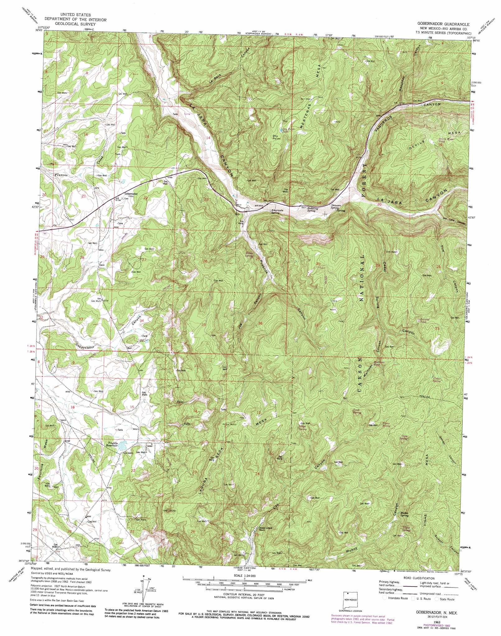
Gobernador Topo Map New Mexico
To zoom in, hover over the map of Gobernador
USGS Topo Quad 36107f3 - 1:24,000 scale
| Topo Map Name: | Gobernador |
| USGS Topo Quad ID: | 36107f3 |
| Print Size: | ca. 21 1/4" wide x 27" high |
| Southeast Coordinates: | 36.625° N latitude / 107.25° W longitude |
| Map Center Coordinates: | 36.6875° N latitude / 107.3125° W longitude |
| U.S. State: | NM |
| Filename: | o36107f3.jpg |
| Download Map JPG Image: | Gobernador topo map 1:24,000 scale |
| Map Type: | Topographic |
| Topo Series: | 7.5´ |
| Map Scale: | 1:24,000 |
| Source of Map Images: | United States Geological Survey (USGS) |
| Alternate Map Versions: |
Gobernador NM 1963, updated 1965 Download PDF Buy paper map Gobernador NM 1963, updated 1981 Download PDF Buy paper map Gobernador NM 1963, updated 1983 Download PDF Buy paper map Gobernador NM 1995, updated 1997 Download PDF Buy paper map Gobernador NM 2011 Download PDF Buy paper map Gobernador NM 2013 Download PDF Buy paper map Gobernador NM 2017 Download PDF Buy paper map |
| FStopo: | US Forest Service topo Gobernador is available: Download FStopo PDF Download FStopo TIF |
1:24,000 Topo Quads surrounding Gobernador
Burnt Mesa |
Bancos Mesa Nw |
Bancos Mesa |
Carracas Canyon |
Wirt Canyon |
Navajo Dam |
Gomez Ranch |
Espinosa Ranch |
Bixler Ranch |
John Mills Lake |
Delgadito Mesa |
Fourmile Canyon |
Gobernador |
Leandro Canyon |
Cement Lake |
Gould Pass |
Santos Peak |
Vigas Canyon |
Pine Lake |
Leavry Canyon |
Smouse Mesa |
Gonzales Mesa |
Lapis Point |
Schmitz Ranch |
Ojito |
> Back to 36107e1 at 1:100,000 scale
> Back to 36106a1 at 1:250,000 scale
> Back to U.S. Topo Maps home
Gobernador topo map: Gazetteer
Gobernador: Capes
Dry Point elevation 2306m 7565′Gobernador: Reservoirs
Trujillo Reservoir elevation 2027m 6650′Gobernador: Springs
Amarante Spring elevation 1996m 6548′Arnold Ranch Spring elevation 2101m 6893′
Bubbling Spring elevation 1996m 6548′
Burro Spring elevation 2003m 6571′
Cave Spring elevation 2258m 7408′
Muñoz Spring elevation 2157m 7076′
Skousen Spring elevation 1998m 6555′
Gobernador: Summits
Laguna Seca Mesa elevation 2319m 7608′Vigas Mesa elevation 2288m 7506′
Gobernador: Valleys
Cedar Spring Canyon elevation 2007m 6584′Dry Lake Canyon elevation 2028m 6653′
Fire Canyon elevation 2019m 6624′
Jog Canyon elevation 2017m 6617′
La Baca Canyon elevation 1957m 6420′
Martinez Canyon elevation 2177m 7142′
Mestenas Canyon elevation 2042m 6699′
Oso Canyon elevation 2050m 6725′
Pueblita Canyon elevation 1982m 6502′
Vaqueros Canyon elevation 1998m 6555′
Gobernador digital topo map on disk
Buy this Gobernador topo map showing relief, roads, GPS coordinates and other geographical features, as a high-resolution digital map file on DVD: