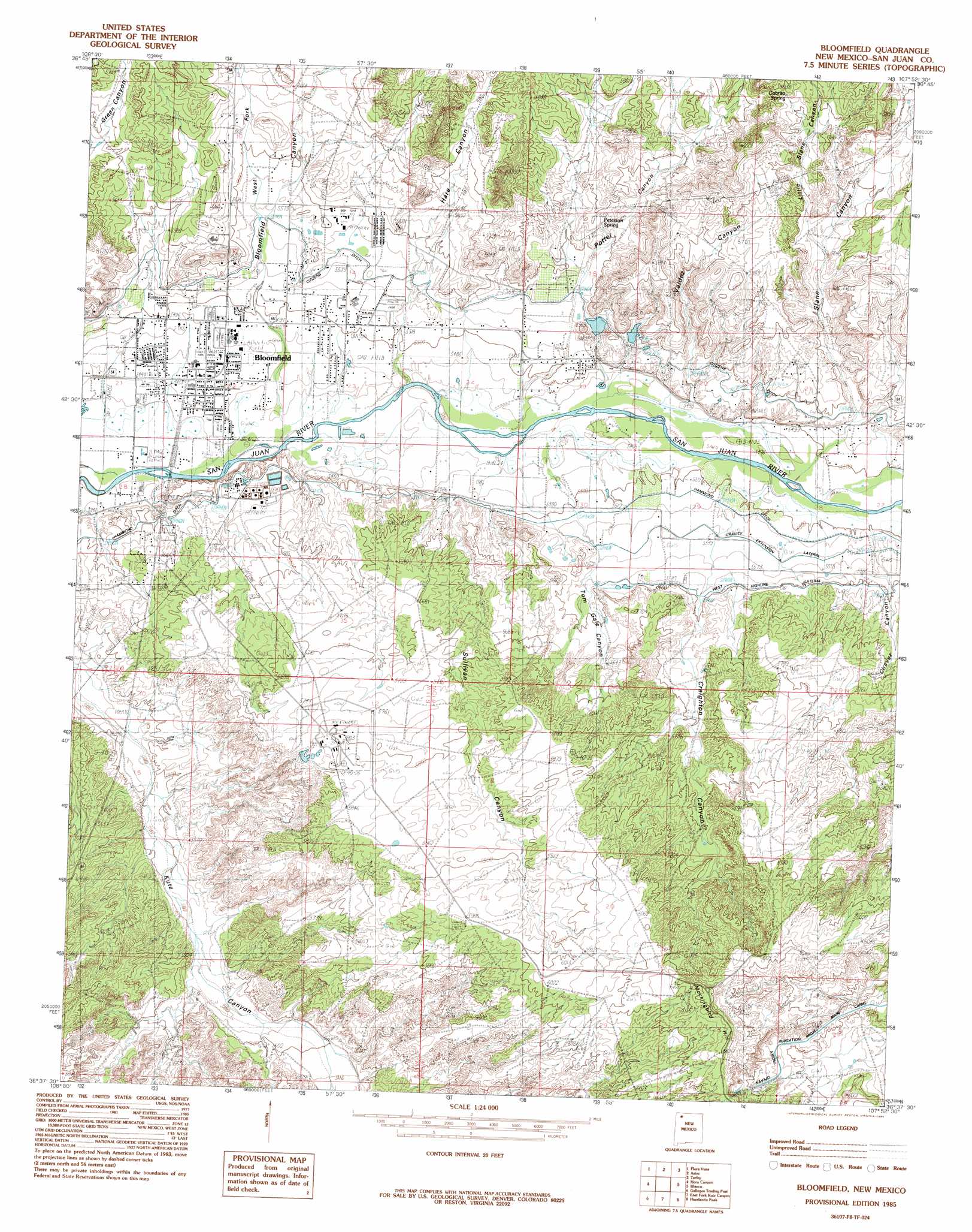
Bloomfield Topo Map New Mexico
To zoom in, hover over the map of Bloomfield
USGS Topo Quad 36107f8 - 1:24,000 scale
| Topo Map Name: | Bloomfield |
| USGS Topo Quad ID: | 36107f8 |
| Print Size: | ca. 21 1/4" wide x 27" high |
| Southeast Coordinates: | 36.625° N latitude / 107.875° W longitude |
| Map Center Coordinates: | 36.6875° N latitude / 107.9375° W longitude |
| U.S. State: | NM |
| Filename: | o36107f8.jpg |
| Download Map JPG Image: | Bloomfield topo map 1:24,000 scale |
| Map Type: | Topographic |
| Topo Series: | 7.5´ |
| Map Scale: | 1:24,000 |
| Source of Map Images: | United States Geological Survey (USGS) |
| Alternate Map Versions: |
Bloomfield NM 1985, updated 1985 Download PDF Buy paper map Bloomfield NM 2010 Download PDF Buy paper map Bloomfield NM 2013 Download PDF Buy paper map Bloomfield NM 2017 Download PDF Buy paper map |
1:24,000 Topo Quads surrounding Bloomfield
La Plata |
Abode Downs Ranch |
Cedar Hill |
Tank Mountain |
Anastacio Spring |
Farmington North |
Flora Vista |
Aztec |
Turley |
Archuleta |
Farmington South |
Horn Canyon |
Bloomfield |
Blanco |
Cutter Canyon |
Hugh Lake |
Gallegos Trading Post |
East Fork Kutz Canyon |
Huerfanito Peak |
Fresno Canyon |
Moncisco Wash |
Carson Trading Post |
Huerfano Trading Post Nw |
Huerfano Trading Post |
Thompson Mesa |
> Back to 36107e1 at 1:100,000 scale
> Back to 36106a1 at 1:250,000 scale
> Back to U.S. Topo Maps home
Bloomfield topo map: Gazetteer
Bloomfield: Canals
Citizens Ditch elevation 1700m 5577′Bloomfield: Populated Places
Bloomfield elevation 1663m 5456′Bloomfield: Post Offices
Bloomfield Post Office elevation 1663m 5456′Bloomfield: Valleys
Bloomfield Canyon elevation 1653m 5423′Creighton Canyon elevation 1670m 5479′
Potter Canyon elevation 1661m 5449′
Slane Canyon elevation 1672m 5485′
Sullivan Canyon elevation 1658m 5439′
Tom Gale Canyon elevation 1662m 5452′
Valdez Draw elevation 1665m 5462′
Bloomfield digital topo map on disk
Buy this Bloomfield topo map showing relief, roads, GPS coordinates and other geographical features, as a high-resolution digital map file on DVD: