Bixler Ranch Topo Map New Mexico
To zoom in, hover over the map of Bixler Ranch
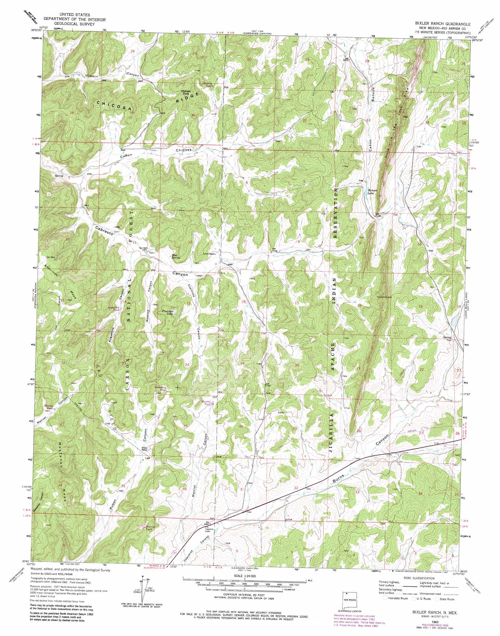
USGS Topo Quad 36107g2 - 1:24,000 scale
| Topo Map Name: | Bixler Ranch |
| USGS Topo Quad ID: | 36107g2 |
| Print Size: | ca. 21 1/4" wide x 27" high |
| Southeast Coordinates: | 36.75° N latitude / 107.125° W longitude |
| Map Center Coordinates: | 36.8125° N latitude / 107.1875° W longitude |
| U.S. State: | NM |
| Filename: | o36107g2.jpg |
| Download Map JPG Image: | Bixler Ranch topo map 1:24,000 scale |
| Map Type: | Topographic |
| Topo Series: | 7.5´ |
| Map Scale: | 1:24,000 |
| Source of Map Images: | United States Geological Survey (USGS) |
| Alternate Map Versions: |
Bixler Ranch NM 1963, updated 1966 Download PDF Buy paper map Bixler Ranch NM 1963, updated 1973 Download PDF Buy paper map Bixler Ranch NM 1963, updated 1983 Download PDF Buy paper map Bixler Ranch NM 1995, updated 1997 Download PDF Buy paper map Bixler Ranch NM 2011 Download PDF Buy paper map Bixler Ranch NM 2013 Download PDF Buy paper map Bixler Ranch NM 2017 Download PDF Buy paper map |
| FStopo: | US Forest Service topo Bixler Ranch is available: Download FStopo PDF Download FStopo TIF |
1:24,000 Topo Quads surrounding Bixler Ranch
Allison |
Carracas |
Pagosa Junction |
Trujillo |
Edith |
Bancos Mesa Nw |
Bancos Mesa |
Carracas Canyon |
Wirt Canyon |
Dulce |
Gomez Ranch |
Espinosa Ranch |
Bixler Ranch |
John Mills Lake |
Cordova Canyon |
Fourmile Canyon |
Gobernador |
Leandro Canyon |
Cement Lake |
Cedar Canyon |
Santos Peak |
Vigas Canyon |
Pine Lake |
Leavry Canyon |
Los Indios Canyon |
> Back to 36107e1 at 1:100,000 scale
> Back to 36106a1 at 1:250,000 scale
> Back to U.S. Topo Maps home
Bixler Ranch topo map: Gazetteer
Bixler Ranch: Basins
San Juan Basin elevation 2222m 7290′Bixler Ranch: Parks
San Juan Basin Historical Marker elevation 2222m 7290′Bixler Ranch: Populated Places
Vaqueros (historical) elevation 2128m 6981′Bixler Ranch: Post Offices
Vanqueras Post Office (historical) elevation 2128m 6981′Bixler Ranch: Reservoirs
Bancos Lake elevation 2161m 7089′Chicosa Tank elevation 2178m 7145′
Preacher Tank elevation 2179m 7148′
Bixler Ranch: Ridges
Chicosa Ridge elevation 2209m 7247′Hole-in-the-Rock-Dike elevation 2302m 7552′
Bixler Ranch: Springs
Mud Spring elevation 2125m 6971′Bixler Ranch: Valleys
Augustine Canyon elevation 2110m 6922′Burns Canyon elevation 2130m 6988′
Cañon Chicosa elevation 2065m 6774′
Espinosa Canyon elevation 2117m 6945′
Maestas Canyon elevation 2110m 6922′
Marcial Canyon elevation 2126m 6975′
Bixler Ranch: Wells
Burns Canyon Water Well elevation 2146m 7040′Caberesto Water Well elevation 2207m 7240′
Calvin Veneno Water Well elevation 2195m 7201′
Farm C-142 Water Well elevation 2159m 7083′
Vaqueros Cabin Water Well elevation 2131m 6991′
Bixler Ranch digital topo map on disk
Buy this Bixler Ranch topo map showing relief, roads, GPS coordinates and other geographical features, as a high-resolution digital map file on DVD: