Espinosa Ranch Topo Map New Mexico
To zoom in, hover over the map of Espinosa Ranch
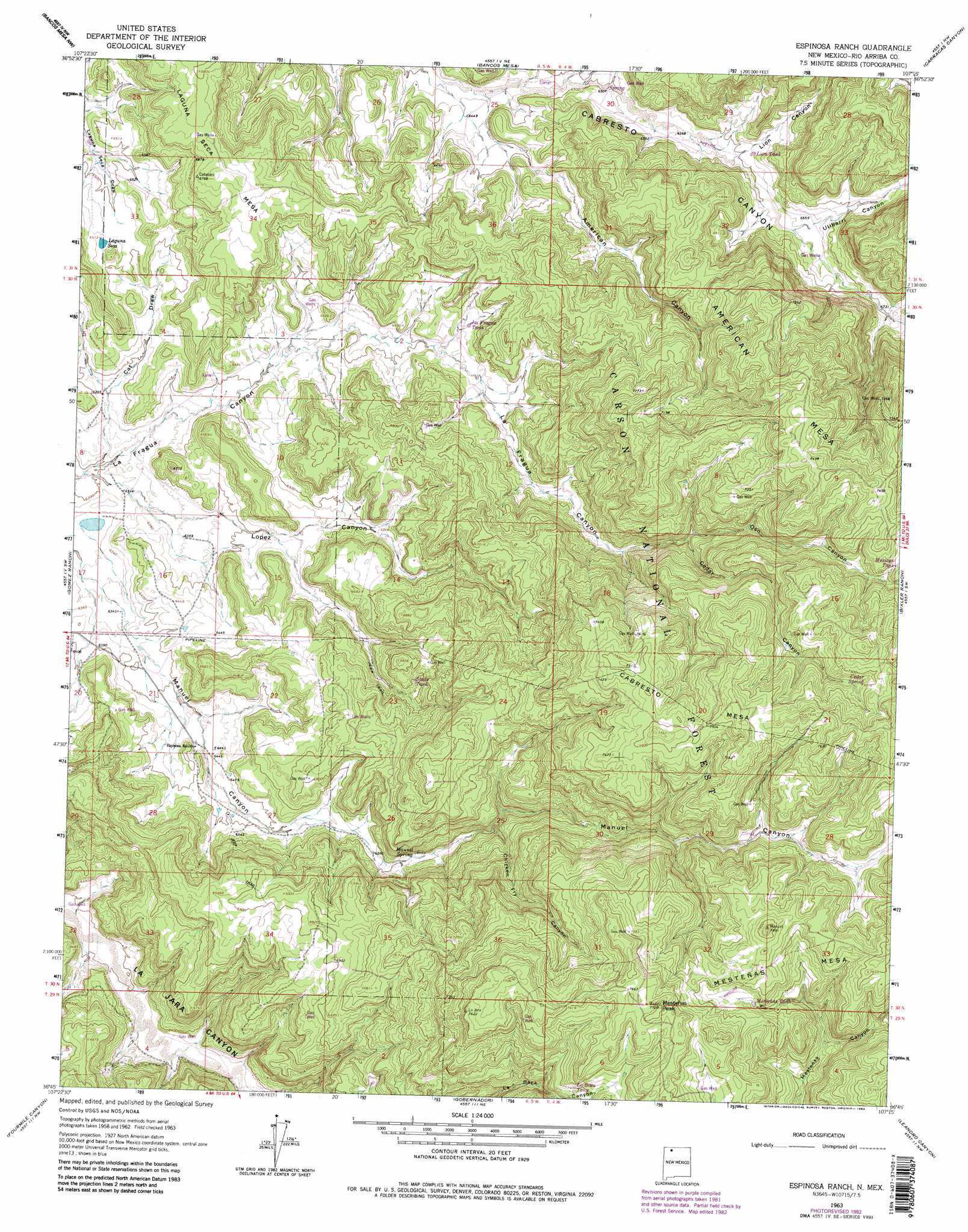
USGS Topo Quad 36107g3 - 1:24,000 scale
| Topo Map Name: | Espinosa Ranch |
| USGS Topo Quad ID: | 36107g3 |
| Print Size: | ca. 21 1/4" wide x 27" high |
| Southeast Coordinates: | 36.75° N latitude / 107.25° W longitude |
| Map Center Coordinates: | 36.8125° N latitude / 107.3125° W longitude |
| U.S. State: | NM |
| Filename: | o36107g3.jpg |
| Download Map JPG Image: | Espinosa Ranch topo map 1:24,000 scale |
| Map Type: | Topographic |
| Topo Series: | 7.5´ |
| Map Scale: | 1:24,000 |
| Source of Map Images: | United States Geological Survey (USGS) |
| Alternate Map Versions: |
Espinosa Ranch NM 1963, updated 1965 Download PDF Buy paper map Espinosa Ranch NM 1963, updated 1975 Download PDF Buy paper map Espinosa Ranch NM 1963, updated 1983 Download PDF Buy paper map Espinosa Ranch NM 1963, updated 1983 Download PDF Buy paper map Espinosa Ranch NM 1995, updated 1997 Download PDF Buy paper map Espinosa Ranch NM 2011 Download PDF Buy paper map Espinosa Ranch NM 2013 Download PDF Buy paper map Espinosa Ranch NM 2017 Download PDF Buy paper map |
| FStopo: | US Forest Service topo Espinosa Ranch is available: Download FStopo PDF Download FStopo TIF |
1:24,000 Topo Quads surrounding Espinosa Ranch
Tiffany |
Allison |
Carracas |
Pagosa Junction |
Trujillo |
Burnt Mesa |
Bancos Mesa Nw |
Bancos Mesa |
Carracas Canyon |
Wirt Canyon |
Navajo Dam |
Gomez Ranch |
Espinosa Ranch |
Bixler Ranch |
John Mills Lake |
Delgadito Mesa |
Fourmile Canyon |
Gobernador |
Leandro Canyon |
Cement Lake |
Gould Pass |
Santos Peak |
Vigas Canyon |
Pine Lake |
Leavry Canyon |
> Back to 36107e1 at 1:100,000 scale
> Back to 36106a1 at 1:250,000 scale
> Back to U.S. Topo Maps home
Espinosa Ranch topo map: Gazetteer
Espinosa Ranch: Forests
Jicarilla Ranger District elevation 2277m 7470′Espinosa Ranch: Lakes
Lopez Lake elevation 1926m 6318′Espinosa Ranch: Mines
Palmer elevation 2005m 6578′Espinosa Ranch: Reservoirs
American Tank elevation 2226m 7303′Laguna Seca elevation 1987m 6519′
Espinosa Ranch: Springs
Manuel Spring elevation 2033m 6669′Two Trough Spring elevation 2255m 7398′
Espinosa Ranch: Summits
American Mesa elevation 2261m 7417′Cabresto Mesa elevation 2280m 7480′
Laguna Seca Mesa elevation 2075m 6807′
Mestenas Mesa elevation 2322m 7618′
Mestenas Peak elevation 2343m 7687′
Espinosa Ranch: Valleys
American Canyon elevation 1976m 6482′Cabrero Canyon elevation 1982m 6502′
Cat Draw elevation 1916m 6286′
Cedar Canyon elevation 2092m 6863′
Chicken Fry Canyon elevation 2041m 6696′
Lion Canyon elevation 2009m 6591′
Lopez Canyon elevation 1921m 6302′
Oso Canyon elevation 2097m 6879′
Ulibarri Canyon elevation 2023m 6637′
Espinosa Ranch digital topo map on disk
Buy this Espinosa Ranch topo map showing relief, roads, GPS coordinates and other geographical features, as a high-resolution digital map file on DVD: