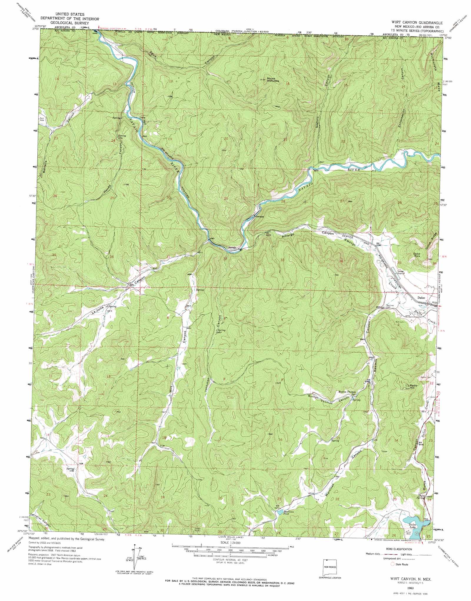
Wirt Canyon Topo Map New Mexico
To zoom in, hover over the map of Wirt Canyon
USGS Topo Quad 36107h1 - 1:24,000 scale
| Topo Map Name: | Wirt Canyon |
| USGS Topo Quad ID: | 36107h1 |
| Print Size: | ca. 21 1/4" wide x 27" high |
| Southeast Coordinates: | 36.875° N latitude / 107° W longitude |
| Map Center Coordinates: | 36.9375° N latitude / 107.0625° W longitude |
| U.S. State: | NM |
| Filename: | o36107h1.jpg |
| Download Map JPG Image: | Wirt Canyon topo map 1:24,000 scale |
| Map Type: | Topographic |
| Topo Series: | 7.5´ |
| Map Scale: | 1:24,000 |
| Source of Map Images: | United States Geological Survey (USGS) |
| Alternate Map Versions: |
Wirt Canyon NM 1963, updated 1966 Download PDF Buy paper map Wirt Canyon NM 2010 Download PDF Buy paper map Wirt Canyon NM 2013 Download PDF Buy paper map Wirt Canyon NM 2017 Download PDF Buy paper map |
1:24,000 Topo Quads surrounding Wirt Canyon
Chimney Rock |
Lonetree Canyon |
Oakbrush Hill |
Serviceberry Mountain |
Harris Lake |
Carracas |
Pagosa Junction |
Trujillo |
Edith |
Chromo |
Bancos Mesa |
Carracas Canyon |
Wirt Canyon |
Dulce |
Monero |
Espinosa Ranch |
Bixler Ranch |
John Mills Lake |
Cordova Canyon |
Horse Lake |
Gobernador |
Leandro Canyon |
Cement Lake |
Cedar Canyon |
Apache Mesa |
> Back to 36107e1 at 1:100,000 scale
> Back to 36106a1 at 1:250,000 scale
> Back to U.S. Topo Maps home
Wirt Canyon topo map: Gazetteer
Wirt Canyon: Dams
Dulce Lake Dam elevation 2147m 7043′Wirt Canyon: Lakes
Martinez Pond elevation 2275m 7463′Wirt Canyon: Populated Places
Navajo elevation 2007m 6584′Wirt Canyon: Reservoirs
Dulce Lake elevation 2147m 7043′Wirt Canyon: Ridges
Dulce Ridge elevation 2288m 7506′Wirt Canyon: Springs
Button Thomas Spring elevation 2145m 7037′Dulce Spring elevation 2136m 7007′
Gomez Spring elevation 2174m 7132′
Pulce Spring elevation 2135m 7004′
Wirt Canyon: Streams
Amargo Creek elevation 2005m 6578′Dulce Creek elevation 2067m 6781′
Wirt Canyon: Summits
Dulce Rock elevation 2221m 7286′Mount Archuleta elevation 2480m 8136′
Radio Hill elevation 2335m 7660′
Wirt Canyon: Valleys
Agua Canyon elevation 1968m 6456′Amargo Canyon elevation 2005m 6578′
Barrella Canyon elevation 1975m 6479′
Button Thomas Canyon elevation 2129m 6984′
Encarnacion Canyon elevation 2049m 6722′
Encarnacion Canyon elevation 2058m 6751′
Hondo Canyon elevation 1979m 6492′
Ishkoten Canyon elevation 2002m 6568′
La Huida Canyon elevation 2077m 6814′
La Juita Canyon elevation 1999m 6558′
Martinez Canyon elevation 2129m 6984′
Sawmill Canyon elevation 2059m 6755′
Seguro Canyon elevation 2033m 6669′
Seguro Canyon elevation 2028m 6653′
Wirt Canyon elevation 2015m 6610′
Wirt Canyon digital topo map on disk
Buy this Wirt Canyon topo map showing relief, roads, GPS coordinates and other geographical features, as a high-resolution digital map file on DVD: