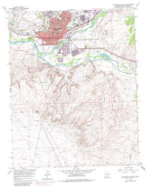
Farmington South Topo Map New Mexico
To zoom in, hover over the map of Farmington South
USGS Topo Quad 36108f2 - 1:24,000 scale
| Topo Map Name: | Farmington South |
| USGS Topo Quad ID: | 36108f2 |
| Print Size: | ca. 21 1/4" wide x 27" high |
| Southeast Coordinates: | 36.625° N latitude / 108.125° W longitude |
| Map Center Coordinates: | 36.6875° N latitude / 108.1875° W longitude |
| U.S. State: | NM |
| Filename: | o36108f2.jpg |
| Download Map JPG Image: | Farmington South topo map 1:24,000 scale |
| Map Type: | Topographic |
| Topo Series: | 7.5´ |
| Map Scale: | 1:24,000 |
| Source of Map Images: | United States Geological Survey (USGS) |
| Alternate Map Versions: |
Farmington South NM 1965, updated 1969 Download PDF Buy paper map Farmington South NM 1965, updated 1970 Download PDF Buy paper map Farmington South NM 1965, updated 1980 Download PDF Buy paper map Farmington South NM 2010 Download PDF Buy paper map Farmington South NM 2013 Download PDF Buy paper map Farmington South NM 2017 Download PDF Buy paper map |
1:24,000 Topo Quads surrounding Farmington South
> Back to 36108e1 at 1:100,000 scale
> Back to 36108a1 at 1:250,000 scale
> Back to U.S. Topo Maps home
Farmington South topo map: Gazetteer
Farmington South: Airports
Four Corners Regional Airport elevation 1676m 5498′Williams Airport elevation 1683m 5521′
Farmington South: Areas
The Dunes elevation 1859m 6099′Farmington South: Canals
Echo Ditch elevation 1630m 5347′Independent Ditch elevation 1669m 5475′
North Farmington Ditch elevation 1624m 5328′
Willett Ditch elevation 1622m 5321′
Farmington South: Cliffs
Shannon Bluffs elevation 1707m 5600′Farmington South: Dams
Bolack Number One Dam elevation 1618m 5308′Farmington South: Mines
Acora Pit elevation 1603m 5259′Arco Pit elevation 1642m 5387′
Bolack Number One elevation 1646m 5400′
Eaton Pit elevation 1598m 5242′
Red Shale Mine elevation 1617m 5305′
Farmington South: Oilfields
The Dunes elevation 1854m 6082′Farmington South: Parks
Boyd Park elevation 1610m 5282′Farmington Historical Marker elevation 1615m 5298′
Jaycee Park elevation 1658m 5439′
Lions Park elevation 1636m 5367′
Farmington South: Populated Places
Farmington elevation 1615m 5298′Farmington South: Post Offices
Farmington Post Office elevation 1615m 5298′Farmington South: Springs
Bentley Spring elevation 1819m 5967′Farmington South: Streams
Animas River elevation 1597m 5239′Farmington Glade elevation 1598m 5242′
Porter Arroyo elevation 1636m 5367′
Farmington South: Valleys
Head Canyon elevation 1615m 5298′Mine Canyon elevation 1629m 5344′
Stewart Canyon elevation 1614m 5295′
Farmington South digital topo map on disk
Buy this Farmington South topo map showing relief, roads, GPS coordinates and other geographical features, as a high-resolution digital map file on DVD:


