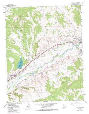
Flora Vista Topo Map New Mexico
To zoom in, hover over the map of Flora Vista
USGS Topo Quad 36108g1 - 1:24,000 scale
| Topo Map Name: | Flora Vista |
| USGS Topo Quad ID: | 36108g1 |
| Print Size: | ca. 21 1/4" wide x 27" high |
| Southeast Coordinates: | 36.75° N latitude / 108° W longitude |
| Map Center Coordinates: | 36.8125° N latitude / 108.0625° W longitude |
| U.S. State: | NM |
| Filename: | o36108g1.jpg |
| Download Map JPG Image: | Flora Vista topo map 1:24,000 scale |
| Map Type: | Topographic |
| Topo Series: | 7.5´ |
| Map Scale: | 1:24,000 |
| Source of Map Images: | United States Geological Survey (USGS) |
| Alternate Map Versions: |
Flora Vista NM 1963, updated 1965 Download PDF Buy paper map Flora Vista NM 1963, updated 1978 Download PDF Buy paper map Flora Vista NM 1963, updated 1980 Download PDF Buy paper map Flora Vista NM 1963, updated 1980 Download PDF Buy paper map Flora Vista NM 2010 Download PDF Buy paper map Flora Vista NM 2013 Download PDF Buy paper map Flora Vista NM 2017 Download PDF Buy paper map |
1:24,000 Topo Quads surrounding Flora Vista
> Back to 36108e1 at 1:100,000 scale
> Back to 36108a1 at 1:250,000 scale
> Back to U.S. Topo Maps home
Flora Vista topo map: Gazetteer
Flora Vista: Airports
Aztec Municipal Airport elevation 1788m 5866′Flora Vista: Canals
Elledge Mill Ditch elevation 1702m 5583′Farmers Ditch elevation 1724m 5656′
Kello Blancett Ditch elevation 1698m 5570′
Lower Animas Ditch elevation 1719m 5639′
Terrell Ditch elevation 1679m 5508′
Flora Vista: Dams
Beeline Farmington Number 3 Reservoir Dam elevation 1692m 5551′Flora Vista: Mines
Airport Pit elevation 1725m 5659′Aztec Gypsum Prospect elevation 1790m 5872′
Spencerville Pit elevation 1778m 5833′
Flora Vista: Populated Places
Flora Vista elevation 1679m 5508′Spencerville elevation 1730m 5675′
Flora Vista: Post Offices
Flora Vista Post Office (historical) elevation 1679m 5508′Flora Vista: Reservoirs
Barton Tank elevation 1784m 5853′Beeline Reservoir elevation 1719m 5639′
Coach Tank elevation 1787m 5862′
Farmer Tank elevation 1797m 5895′
Flora Vista Tank elevation 1764m 5787′
Hickman Tank elevation 1785m 5856′
Lake Farmington elevation 1692m 5551′
Wyper Tank elevation 1739m 5705′
Flora Vista: Springs
Aztec Peach Spring elevation 1705m 5593′Flora Vista: Streams
Barton Arroyo elevation 1683m 5521′Blancett Arroyo elevation 1684m 5524′
Burns Arroyo elevation 1671m 5482′
Cook Arroyo elevation 1688m 5538′
Estes Arroyo elevation 1708m 5603′
Flora Vista Arroyo elevation 1672m 5485′
Hargis Arroyo elevation 1653m 5423′
Hedges Arroyo elevation 1817m 5961′
Johnson Arroyo elevation 1696m 5564′
Jones Arroyo elevation 1675m 5495′
Kochis Arroyo elevation 1690m 5544′
Rabbit Arroyo elevation 1702m 5583′
Williams Arroyo elevation 1700m 5577′
Wyper Arroyo elevation 1656m 5433′
Flora Vista: Summits
Bald Mesa elevation 1706m 5597′Flora Vista digital topo map on disk
Buy this Flora Vista topo map showing relief, roads, GPS coordinates and other geographical features, as a high-resolution digital map file on DVD:


