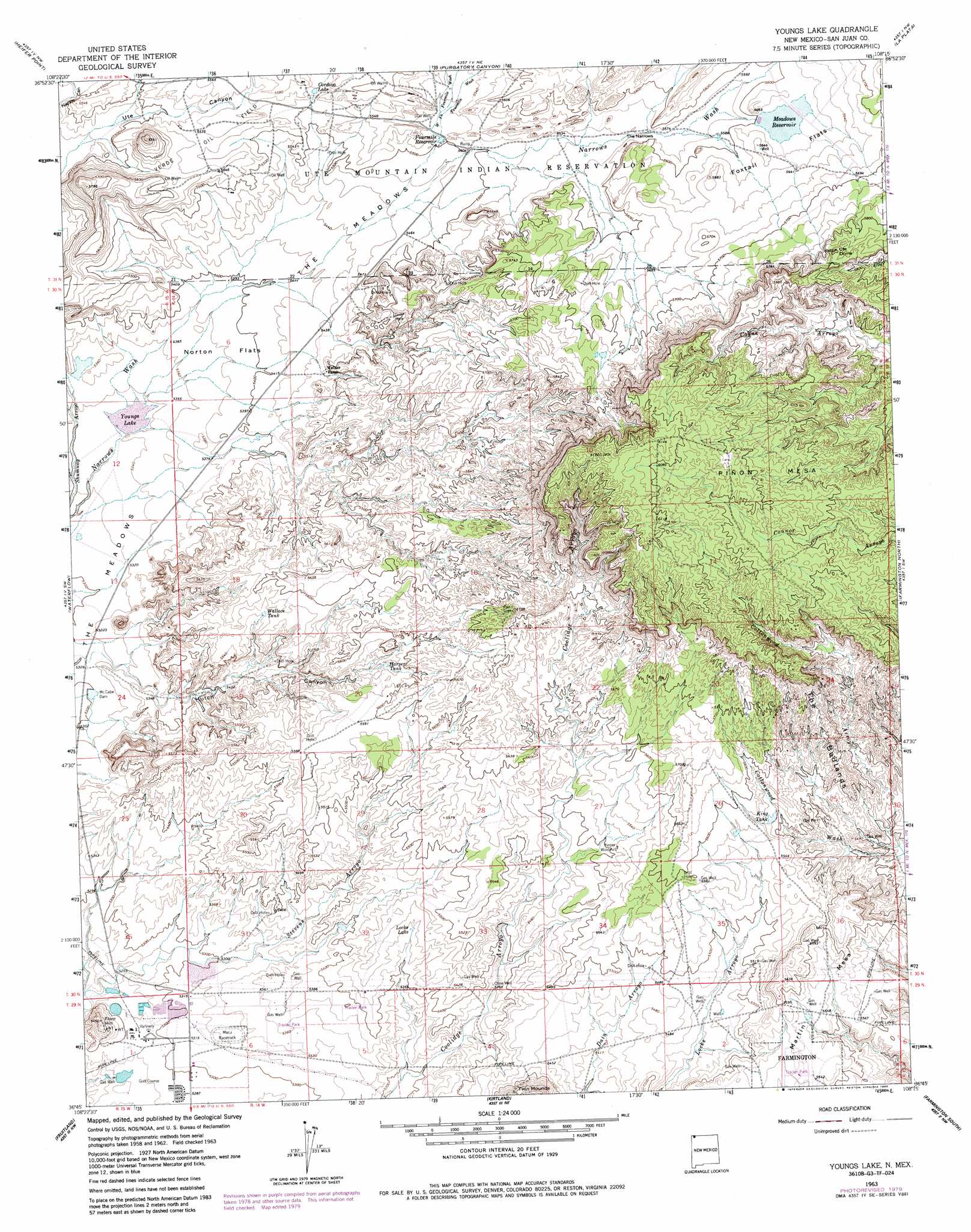
Youngs Lake Topo Map New Mexico
To zoom in, hover over the map of Youngs Lake
USGS Topo Quad 36108g3 - 1:24,000 scale
| Topo Map Name: | Youngs Lake |
| USGS Topo Quad ID: | 36108g3 |
| Print Size: | ca. 21 1/4" wide x 27" high |
| Southeast Coordinates: | 36.75° N latitude / 108.25° W longitude |
| Map Center Coordinates: | 36.8125° N latitude / 108.3125° W longitude |
| U.S. State: | NM |
| Filename: | o36108g3.jpg |
| Download Map JPG Image: | Youngs Lake topo map 1:24,000 scale |
| Map Type: | Topographic |
| Topo Series: | 7.5´ |
| Map Scale: | 1:24,000 |
| Source of Map Images: | United States Geological Survey (USGS) |
| Alternate Map Versions: |
Youngs Lake NM 1963, updated 1966 Download PDF Buy paper map Youngs Lake NM 1963, updated 1980 Download PDF Buy paper map Youngs Lake NM 1963, updated 1986 Download PDF Buy paper map Youngs Lake NM 2010 Download PDF Buy paper map Youngs Lake NM 2013 Download PDF Buy paper map Youngs Lake NM 2017 Download PDF Buy paper map |
1:24,000 Topo Quads surrounding Youngs Lake
Moqui Canyon |
Greasewood Canyon |
Red Horse Gulch |
Redmesa |
Pinkerton Mesa |
Palmer Mesa |
Heifer Point |
Purgatory Canyon |
La Plata |
Abode Downs Ranch |
Chimney Rock |
Waterflow |
Youngs Lake |
Farmington North |
Flora Vista |
The Hogack North |
Fruitland |
Kirtland |
Farmington South |
Horn Canyon |
The Hogback South |
Kirtland Sw |
Kirtland Se |
Hugh Lake |
Gallegos Trading Post |
> Back to 36108e1 at 1:100,000 scale
> Back to 36108a1 at 1:250,000 scale
> Back to U.S. Topo Maps home
Youngs Lake topo map: Gazetteer
Youngs Lake: Dams
McCabe Dam elevation 1616m 5301′Youngs Lake: Flats
Foxtail Flats elevation 1717m 5633′Norton Flats elevation 1641m 5383′
Youngs Lake: Gaps
The Narrows elevation 1696m 5564′Youngs Lake: Lakes
Locke Lake elevation 1659m 5442′Youngs Lake: Reservoirs
Cordova Lake elevation 1692m 5551′Fourmile Reservoir elevation 1678m 5505′
Harper Tank elevation 1691m 5547′
King Tank elevation 1684m 5524′
Meadows Reservoir elevation 1711m 5613′
Wallace Tank elevation 1690m 5544′
Youngs Lake elevation 1626m 5334′
Youngs Lake: Streams
Cottonwood Wash elevation 1638m 5374′Fourmile Wash elevation 1661m 5449′
West Fork Fourmile Wash elevation 1679m 5508′
Youngs Lake: Summits
Flare Hill elevation 1655m 5429′Martin Mesa elevation 1724m 5656′
Pinon Mesa elevation 1873m 6145′
Ute Dome elevation 1796m 5892′
Youngs Lake: Wells
A-14 Water Well elevation 1691m 5547′A-16 Water Well elevation 1722m 5649′
Cline Well elevation 1635m 5364′
GT-1 Water Well elevation 1612m 5288′
GT-2 Water Well elevation 1612m 5288′
SJ-13-2 Water Well elevation 1638m 5374′
SJ-24-4 Water Well elevation 1640m 5380′
Youngs Lake digital topo map on disk
Buy this Youngs Lake topo map showing relief, roads, GPS coordinates and other geographical features, as a high-resolution digital map file on DVD: