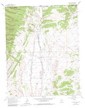
La Plata Topo Map New Mexico
To zoom in, hover over the map of La Plata
USGS Topo Quad 36108h2 - 1:24,000 scale
| Topo Map Name: | La Plata |
| USGS Topo Quad ID: | 36108h2 |
| Print Size: | ca. 21 1/4" wide x 27" high |
| Southeast Coordinates: | 36.875° N latitude / 108.125° W longitude |
| Map Center Coordinates: | 36.9375° N latitude / 108.1875° W longitude |
| U.S. States: | NM, CO |
| Filename: | o36108h2.jpg |
| Download Map JPG Image: | La Plata topo map 1:24,000 scale |
| Map Type: | Topographic |
| Topo Series: | 7.5´ |
| Map Scale: | 1:24,000 |
| Source of Map Images: | United States Geological Survey (USGS) |
| Alternate Map Versions: |
La Plata NM 1963, updated 1965 Download PDF Buy paper map La Plata NM 1963, updated 1980 Download PDF Buy paper map La Plata NM 1963, updated 1983 Download PDF Buy paper map La Plata NM 2010 Download PDF Buy paper map La Plata NM 2013 Download PDF Buy paper map La Plata NM 2017 Download PDF Buy paper map |
1:24,000 Topo Quads surrounding La Plata
> Back to 36108e1 at 1:100,000 scale
> Back to 36108a1 at 1:250,000 scale
> Back to U.S. Topo Maps home
La Plata topo map: Gazetteer
La Plata: Benches
Conger Mesa elevation 1791m 5875′La Plata: Canals
Cunningham Ditch elevation 1749m 5738′Enterprise Ditch elevation 1827m 5994′
Greenhorn Ditch elevation 1792m 5879′
Helton Ditch elevation 1724m 5656′
Highland Park Ditch elevation 1780m 5839′
Hillside Thomas Ditch elevation 1804m 5918′
La Plata Indian Ditch elevation 1781m 5843′
Lefthand Ditch elevation 1750m 5741′
McDermott Ditch elevation 1753m 5751′
Pioneer Ditch elevation 1829m 6000′
Pioneer Ditch elevation 1825m 5987′
Tunnel Ditch elevation 1805m 5921′
La Plata: Dams
Blue Rock Dam elevation 1787m 5862′Silver Pipe Dam elevation 1770m 5807′
La Plata: Mines
Bill Thomas Mine elevation 1824m 5984′Burt Thomas Mine elevation 1810m 5938′
Enterprise Mine elevation 1835m 6020′
Fields Mine elevation 1782m 5846′
Jones Mine elevation 1816m 5958′
Kempton-Prewitt elevation 1840m 6036′
La Plata Mine elevation 1810m 5938′
Morgan Mine elevation 1860m 6102′
Morgan Mines elevation 1824m 5984′
Pruitt Mine elevation 1836m 6023′
Thomas Mine elevation 1815m 5954′
Thomas Mine elevation 1820m 5971′
La Plata: Populated Places
La Plata elevation 1764m 5787′La Plata: Post Offices
La Plata Post Office elevation 1764m 5787′Laplata Post Office elevation 1752m 5748′
La Plata: Reservoirs
Blue Lake elevation 1786m 5859′Blue Rock Tank elevation 1787m 5862′
Conger Lake elevation 1766m 5793′
Talley Tank elevation 1835m 6020′
La Plata: Springs
Barrel Spring elevation 1738m 5702′La Plata: Streams
Blue Lake Wash elevation 1768m 5800′Craig Arroyo elevation 1720m 5643′
Dawson Arroyo elevation 1812m 5944′
Hartley Wash elevation 1758m 5767′
Jaquez Arroyo elevation 1781m 5843′
Jones Arroyo elevation 1839m 6033′
Little Barker Arroyo elevation 1793m 5882′
Manuel Arroyo elevation 1799m 5902′
McDermott Arroyo elevation 1726m 5662′
Mefford Wash elevation 1824m 5984′
Mefford Wash elevation 1818m 5964′
Murphy Arroyo elevation 1884m 6181′
Thomas Arroyo elevation 1792m 5879′
Thompson Arroyo elevation 1709m 5606′
Two Cross Arroyo elevation 1720m 5643′
La Plata: Valleys
Cinder Gulch elevation 1791m 5875′Cinder Gulch elevation 1792m 5879′
Coalbank Canyon elevation 1781m 5843′
Dawson Arroyo elevation 1810m 5938′
Middle Jones Canyon elevation 1873m 6145′
North Buzan Canyon elevation 1884m 6181′
North Jones Canyon elevation 1835m 6020′
North Thomas Canyon elevation 1816m 5958′
North Thomas Canyon elevation 1822m 5977′
Oak Springs Canyon elevation 1824m 5984′
Pump Canyon elevation 1824m 5984′
South Buzan Canyon elevation 1884m 6181′
South Jones Canyon elevation 1835m 6020′
South Thomas Canyon elevation 1822m 5977′
Trail Canyon elevation 1811m 5941′
Walker Canyon elevation 1745m 5725′
La Plata: Wells
Deep Water Well Number 1 elevation 1831m 6007′PC-1 Water Well elevation 1802m 5912′
La Plata digital topo map on disk
Buy this La Plata topo map showing relief, roads, GPS coordinates and other geographical features, as a high-resolution digital map file on DVD:


