Del Merto Topo Map Arizona
To zoom in, hover over the map of Del Merto
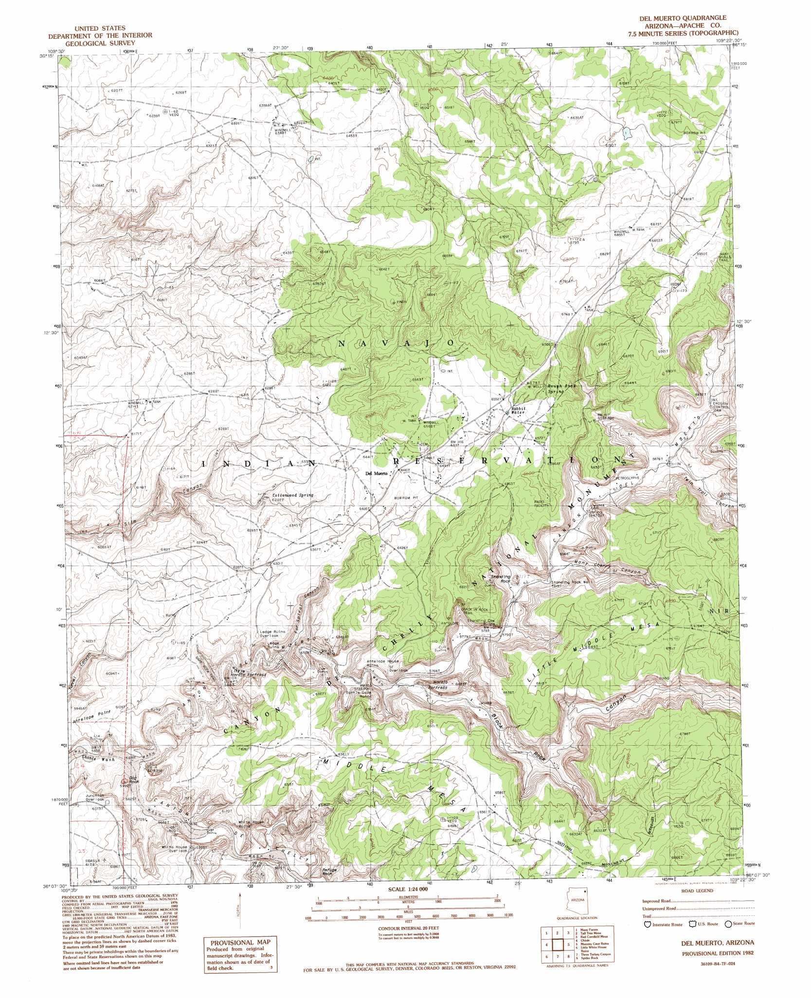
USGS Topo Quad 36109b4 - 1:24,000 scale
| Topo Map Name: | Del Merto |
| USGS Topo Quad ID: | 36109b4 |
| Print Size: | ca. 21 1/4" wide x 27" high |
| Southeast Coordinates: | 36.125° N latitude / 109.375° W longitude |
| Map Center Coordinates: | 36.1875° N latitude / 109.4375° W longitude |
| U.S. State: | AZ |
| Filename: | o36109b4.jpg |
| Download Map JPG Image: | Del Merto topo map 1:24,000 scale |
| Map Type: | Topographic |
| Topo Series: | 7.5´ |
| Map Scale: | 1:24,000 |
| Source of Map Images: | United States Geological Survey (USGS) |
| Alternate Map Versions: |
Sonsala Butte 3 NW AZ 1955, updated 1958 Download PDF Buy paper map Del Muerto AZ 1982, updated 1983 Download PDF Buy paper map Del Muerto AZ 2011 Download PDF Buy paper map Del Muerto AZ 2014 Download PDF Buy paper map |
1:24,000 Topo Quads surrounding Del Merto
Windy Valley |
Many Farms Ne |
Fire Dance Mesa |
Bad Bug Butte |
Lukachukai |
Many Farms Sw |
Many Farms |
Tall Tree Mesa |
Red Cornfield Mesa |
Tsaile |
Ventana Mesa |
Chinle |
Del Merto |
Mummy Cave Ruins |
Lower Wheatfields |
Toh De Niihe |
Little White House Ruins |
Three Turkey Canyon |
Spider Rock |
White Clay |
Tolani |
Beautiful Valley Well |
Nazlini |
White Rock Wash |
Sawmill |
> Back to 36109a1 at 1:100,000 scale
> Back to 36108a1 at 1:250,000 scale
> Back to U.S. Topo Maps home
Del Merto topo map: Gazetteer
Del Merto: Areas
Tiba Dah Silahi elevation 1885m 6184′Del Merto: Populated Places
Del Muerto elevation 1963m 6440′Junction Overlook elevation 1849m 6066′
Del Merto: Reservoirs
Rabbit Water elevation 1992m 6535′Del Merto: Ridges
Refuge Rock elevation 1867m 6125′Del Merto: Springs
Cottonwood Spring elevation 1891m 6204′Rough Rock Spring elevation 2006m 6581′
Del Merto: Summits
Dog Rock elevation 1819m 5967′Navajo Fortress elevation 1755m 5757′
Standing Rock elevation 1861m 6105′
Del Merto: Trails
Antelope Trail elevation 1950m 6397′Crack in Rock Trail elevation 1949m 6394′
Many Ladders Trail elevation 1826m 5990′
Many Skulls Trail elevation 2113m 6932′
Maos Trail elevation 1834m 6017′
Womans Trail elevation 1758m 5767′
Del Merto: Valleys
Black Rock Canyon elevation 1755m 5757′Canyon del Muerto elevation 1712m 5616′
Far Spiral Canyon elevation 1737m 5698′
Many Cherry Canyon elevation 1776m 5826′
Twin Trail Canyon elevation 1800m 5905′
Del Merto digital topo map on disk
Buy this Del Merto topo map showing relief, roads, GPS coordinates and other geographical features, as a high-resolution digital map file on DVD: