Tah Chee Wash Topo Map Arizona
To zoom in, hover over the map of Tah Chee Wash
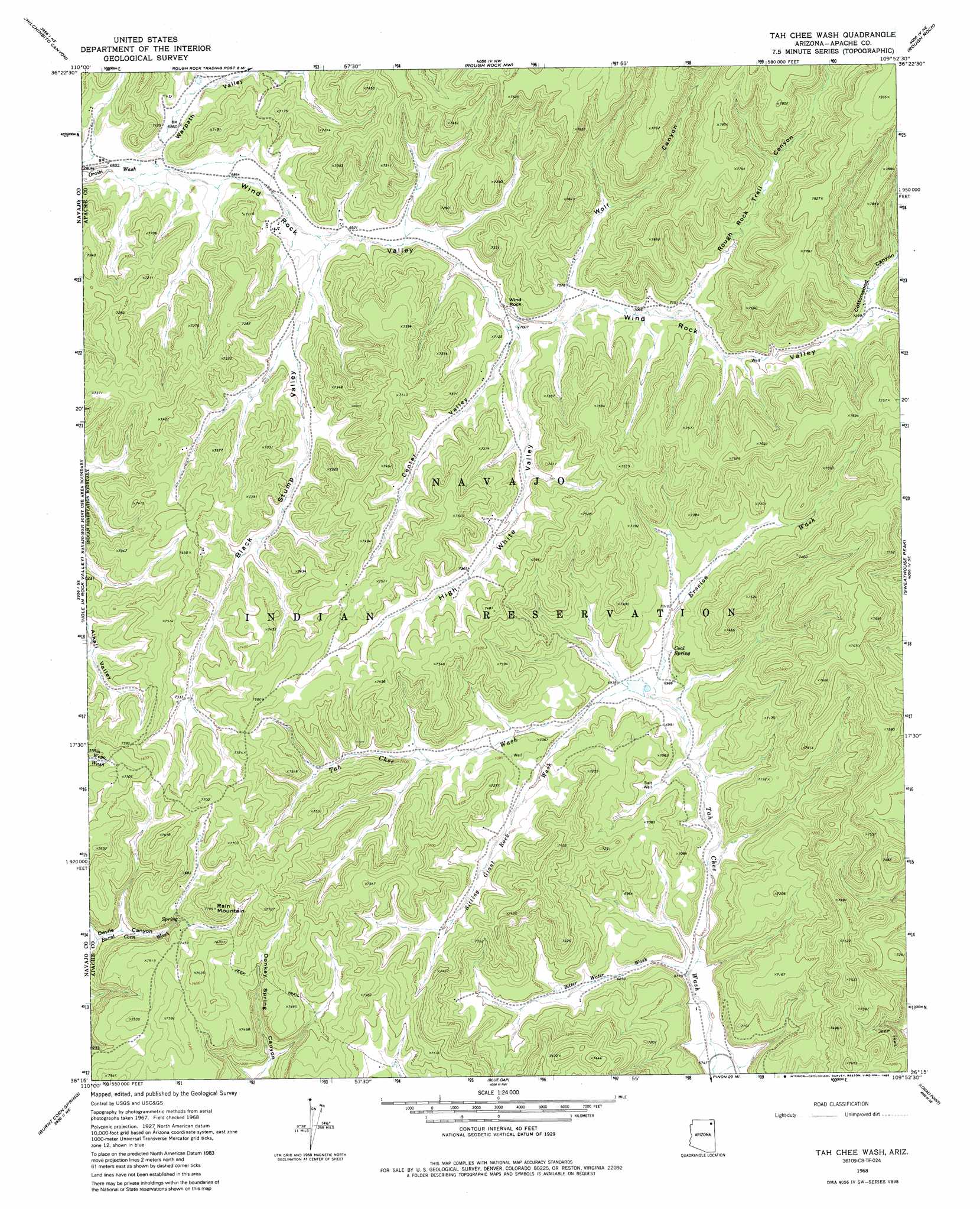
USGS Topo Quad 36109c8 - 1:24,000 scale
| Topo Map Name: | Tah Chee Wash |
| USGS Topo Quad ID: | 36109c8 |
| Print Size: | ca. 21 1/4" wide x 27" high |
| Southeast Coordinates: | 36.25° N latitude / 109.875° W longitude |
| Map Center Coordinates: | 36.3125° N latitude / 109.9375° W longitude |
| U.S. State: | AZ |
| Filename: | o36109c8.jpg |
| Download Map JPG Image: | Tah Chee Wash topo map 1:24,000 scale |
| Map Type: | Topographic |
| Topo Series: | 7.5´ |
| Map Scale: | 1:24,000 |
| Source of Map Images: | United States Geological Survey (USGS) |
| Alternate Map Versions: |
Tah Chee Wash AZ 1968, updated 1972 Download PDF Buy paper map Tah Chee Wash AZ 1968, updated 1985 Download PDF Buy paper map Tah Chee Wash AZ 2011 Download PDF Buy paper map Tah Chee Wash AZ 2014 Download PDF Buy paper map |
1:24,000 Topo Quads surrounding Tah Chee Wash
Owl Spring |
Chilchinbito |
Sweetwater Mesa |
White Point |
Rock Point Sw |
Cliff Rose Hill |
Chilchinbito Canyon |
Rough Rock Nw |
Rough Rock |
Windy Valley |
Toh Ne Zhonnie Spring |
Hole In Rock Valley |
Tah Chee Wash |
Sweathouse Peak |
Many Farms Sw |
Pinon Nw |
Burnt Corn Spring |
Blue Gap |
Lohali Point |
Ventana Mesa |
Pinon |
Whippoorwill Spring |
Toadimdaaska Mesa |
Salina |
Toh De Niihe |
> Back to 36109a1 at 1:100,000 scale
> Back to 36108a1 at 1:250,000 scale
> Back to U.S. Topo Maps home
Tah Chee Wash topo map: Gazetteer
Tah Chee Wash: Pillars
Wind Rock elevation 2166m 7106′Tah Chee Wash: Springs
Coal Spring elevation 2124m 6968′Tah Chee Wash: Summits
Rain Mountain elevation 2371m 7778′Tah Chee Wash: Valleys
Bitter Water Wash elevation 2068m 6784′Black Stump Valley elevation 2108m 6916′
Center Valley elevation 2142m 7027′
Cottonwood Canyon elevation 2226m 7303′
Erosion Wash elevation 2118m 6948′
High White Valley elevation 2143m 7030′
Rough Rock Trail Canyon elevation 2175m 7135′
Sitting Giant Rock Wash elevation 2123m 6965′
Warpath Valley elevation 2090m 6856′
Wind Rock Valley elevation 2086m 6843′
Wolf Canyon elevation 2151m 7057′
Tah Chee Wash digital topo map on disk
Buy this Tah Chee Wash topo map showing relief, roads, GPS coordinates and other geographical features, as a high-resolution digital map file on DVD: