Rocky Ridge Se Topo Map Arizona
To zoom in, hover over the map of Rocky Ridge Se
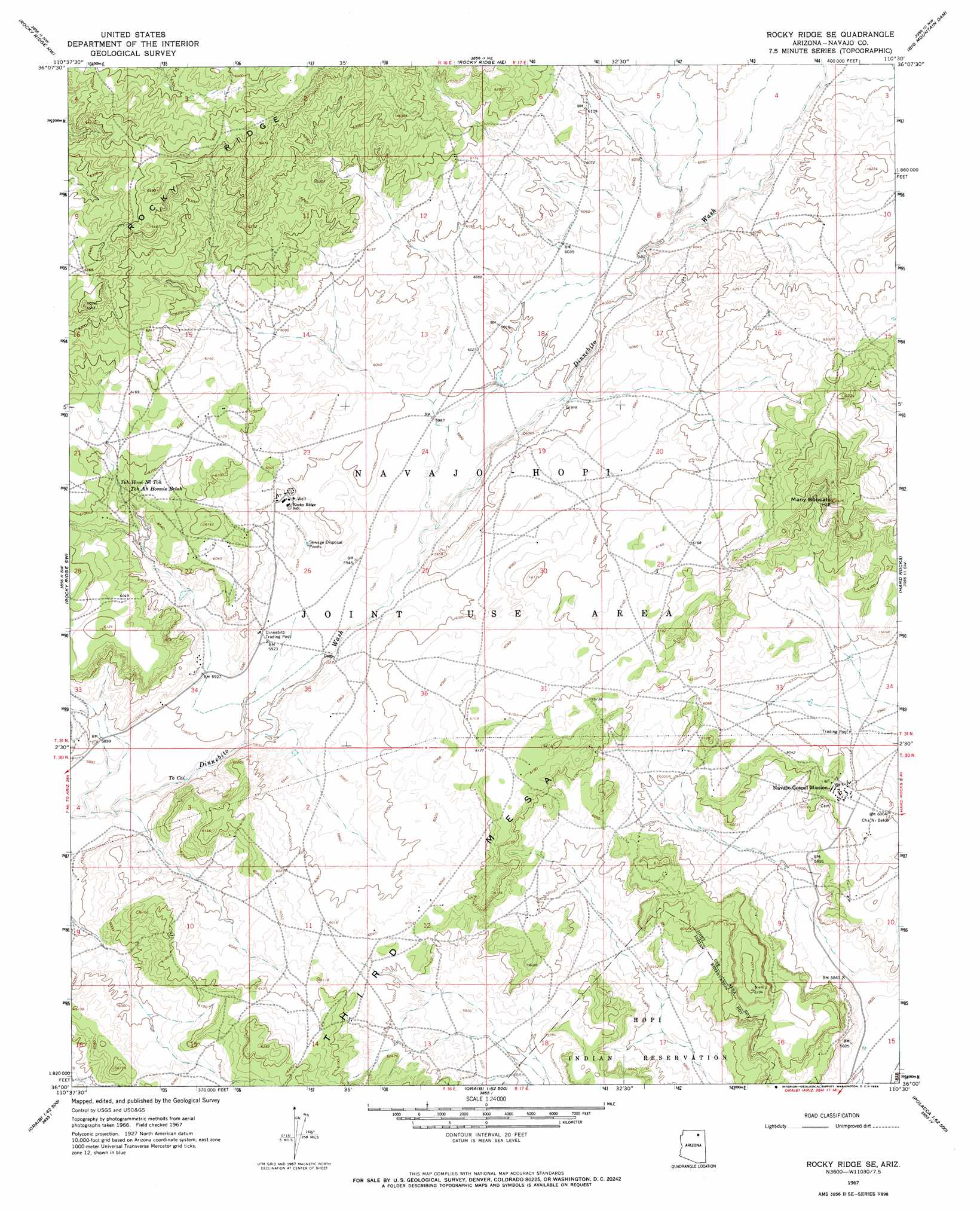
USGS Topo Quad 36110a5 - 1:24,000 scale
| Topo Map Name: | Rocky Ridge Se |
| USGS Topo Quad ID: | 36110a5 |
| Print Size: | ca. 21 1/4" wide x 27" high |
| Southeast Coordinates: | 36° N latitude / 110.5° W longitude |
| Map Center Coordinates: | 36.0625° N latitude / 110.5625° W longitude |
| U.S. State: | AZ |
| Filename: | o36110a5.jpg |
| Download Map JPG Image: | Rocky Ridge Se topo map 1:24,000 scale |
| Map Type: | Topographic |
| Topo Series: | 7.5´ |
| Map Scale: | 1:24,000 |
| Source of Map Images: | United States Geological Survey (USGS) |
| Alternate Map Versions: |
Rocky Ridge Se AZ 1967, updated 1969 Download PDF Buy paper map Rocky Ridge SE AZ 2011 Download PDF Buy paper map Rocky Ridge SE AZ 2014 Download PDF Buy paper map |
1:24,000 Topo Quads surrounding Rocky Ridge Se
John Daw Mesa |
Kydestea Spring |
Red Willow Spring |
Owl Valley |
Red Slide Peak |
Pillars Of Hercules |
Rocky Ridge Nw |
Rocky Ridge Ne |
Big Mountain Dam |
Coat Spring |
Bat Spring |
Rocky Ridge Sw |
Rocky Ridge Se |
Hard Rocks |
Little Black Spot Mountain |
Howell Mesa |
Hotevilla |
Oraibi |
Onion Spring |
Wepo Village |
Padilla Mesa |
Mount Beautiful |
Shongopovi |
Polacca |
Sun Altar |
> Back to 36110a1 at 1:100,000 scale
> Back to 36110a1 at 1:250,000 scale
> Back to U.S. Topo Maps home
Rocky Ridge Se topo map: Gazetteer
Rocky Ridge Se: Airports
Rocky Ridge Airport elevation 1809m 5935′Rocky Ridge Se: Populated Places
Navajo Gospel Mission elevation 1835m 6020′Rocky Ridge Se: Ridges
Rocky Ridge elevation 1931m 6335′Rocky Ridge Se: Springs
To Cai elevation 1784m 5853′Toh Ah Honnie Betoh elevation 1848m 6062′
Toh Honi Ni Toh elevation 1848m 6062′
Rocky Ridge Se: Summits
Many Bobcats Hill elevation 1958m 6423′Third Mesa elevation 1858m 6095′
Rocky Ridge Se digital topo map on disk
Buy this Rocky Ridge Se topo map showing relief, roads, GPS coordinates and other geographical features, as a high-resolution digital map file on DVD: