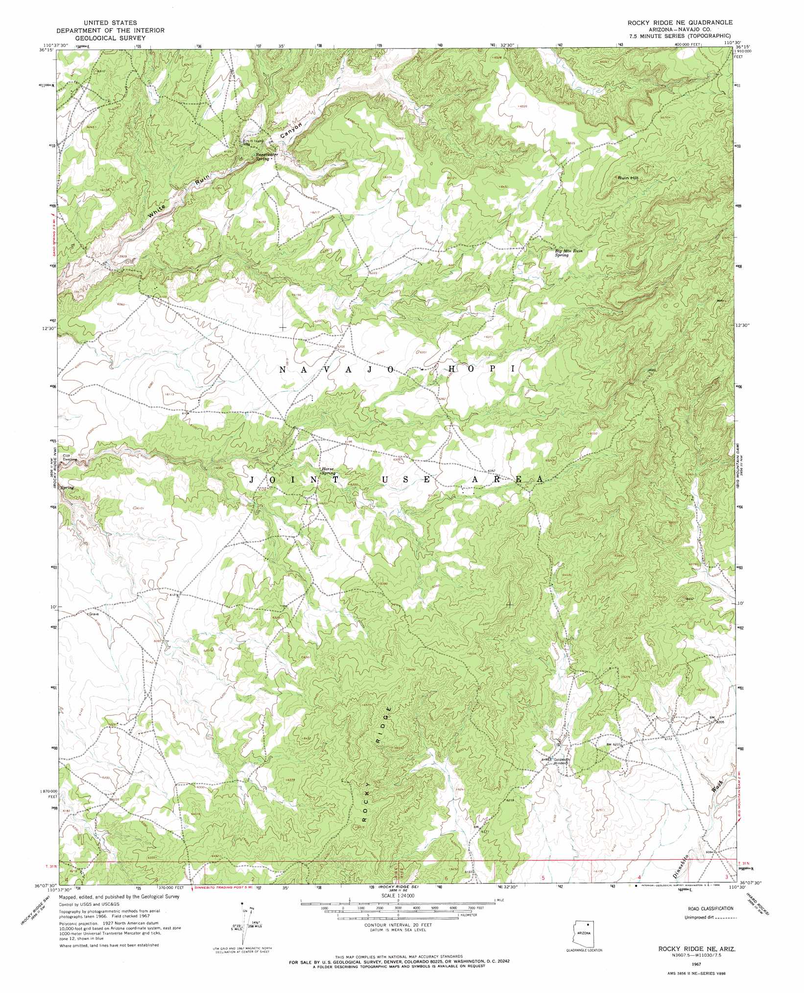
Rocky Ridge Ne Topo Map Arizona
To zoom in, hover over the map of Rocky Ridge Ne
USGS Topo Quad 36110b5 - 1:24,000 scale
| Topo Map Name: | Rocky Ridge Ne |
| USGS Topo Quad ID: | 36110b5 |
| Print Size: | ca. 21 1/4" wide x 27" high |
| Southeast Coordinates: | 36.125° N latitude / 110.5° W longitude |
| Map Center Coordinates: | 36.1875° N latitude / 110.5625° W longitude |
| U.S. State: | AZ |
| Filename: | o36110b5.jpg |
| Download Map JPG Image: | Rocky Ridge Ne topo map 1:24,000 scale |
| Map Type: | Topographic |
| Topo Series: | 7.5´ |
| Map Scale: | 1:24,000 |
| Source of Map Images: | United States Geological Survey (USGS) |
| Alternate Map Versions: |
Rocky Ridge NE AZ 1967, updated 1969 Download PDF Buy paper map Rocky Ridge NE AZ 2011 Download PDF Buy paper map Rocky Ridge NE AZ 2014 Download PDF Buy paper map |
1:24,000 Topo Quads surrounding Rocky Ridge Ne
Cow Springs |
Black Mesa Wash Nw |
Black Mesa Wash Ne |
Great Spring |
Yucca Hill |
John Daw Mesa |
Kydestea Spring |
Red Willow Spring |
Owl Valley |
Red Slide Peak |
Pillars Of Hercules |
Rocky Ridge Nw |
Rocky Ridge Ne |
Big Mountain Dam |
Coat Spring |
Bat Spring |
Rocky Ridge Sw |
Rocky Ridge Se |
Hard Rocks |
Little Black Spot Mountain |
Howell Mesa |
Hotevilla |
Oraibi |
Onion Spring |
Wepo Village |
> Back to 36110a1 at 1:100,000 scale
> Back to 36110a1 at 1:250,000 scale
> Back to U.S. Topo Maps home
Rocky Ridge Ne topo map: Gazetteer
Rocky Ridge Ne: Springs
Big Mountain Ruin Spring elevation 1954m 6410′Horse Spring elevation 1872m 6141′
Sweetwater Spring elevation 1837m 6026′
Rocky Ridge Ne: Summits
Ruin Hill elevation 0m 0′Rocky Ridge Ne: Wells
Kin ni taahll Well elevation 1838m 6030′Rocky Ridge Ne digital topo map on disk
Buy this Rocky Ridge Ne topo map showing relief, roads, GPS coordinates and other geographical features, as a high-resolution digital map file on DVD: