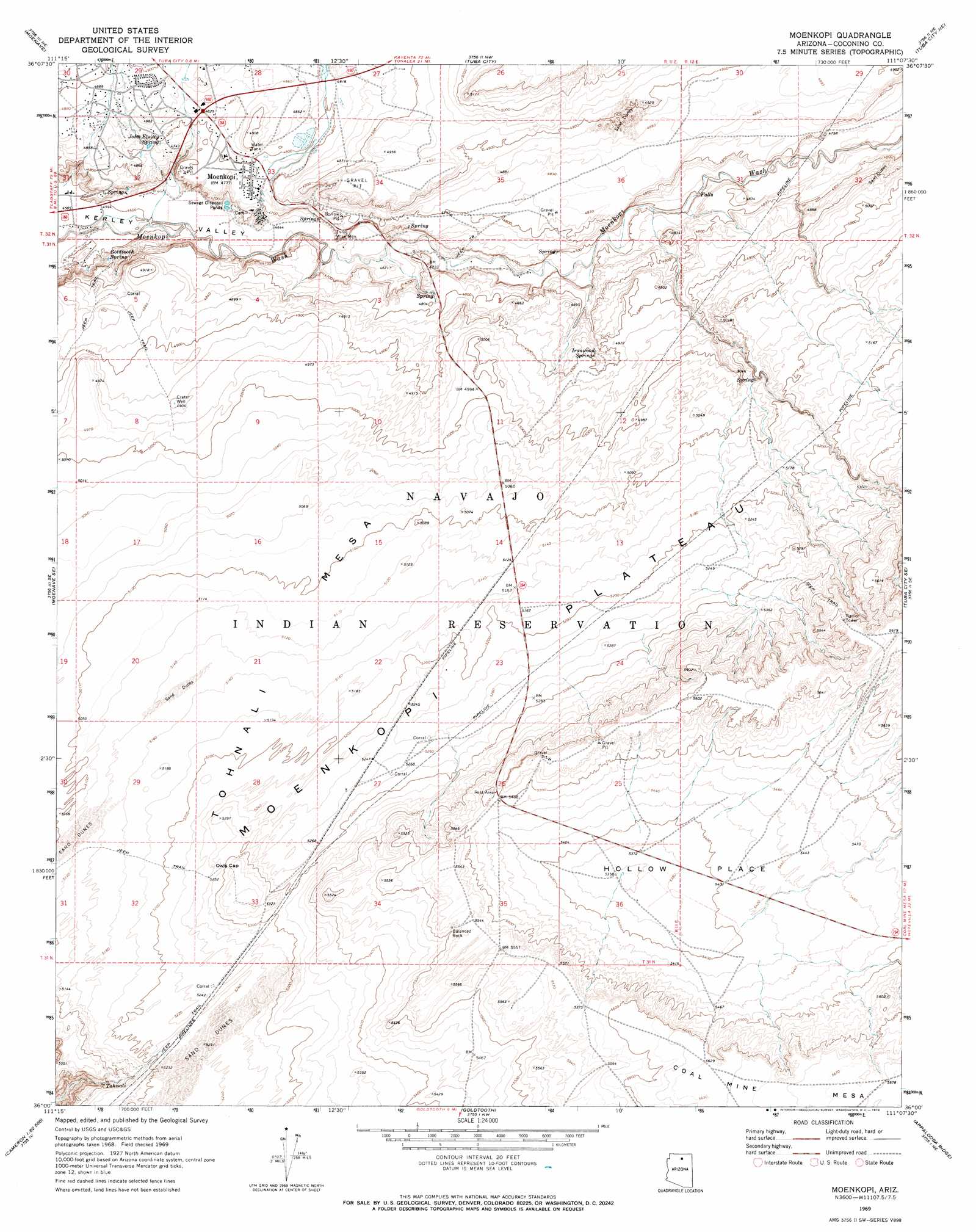
Moenkopi Topo Map Arizona
To zoom in, hover over the map of Moenkopi
USGS Topo Quad 36111a2 - 1:24,000 scale
| Topo Map Name: | Moenkopi |
| USGS Topo Quad ID: | 36111a2 |
| Print Size: | ca. 21 1/4" wide x 27" high |
| Southeast Coordinates: | 36° N latitude / 111.125° W longitude |
| Map Center Coordinates: | 36.0625° N latitude / 111.1875° W longitude |
| U.S. State: | AZ |
| Filename: | o36111a2.jpg |
| Download Map JPG Image: | Moenkopi topo map 1:24,000 scale |
| Map Type: | Topographic |
| Topo Series: | 7.5´ |
| Map Scale: | 1:24,000 |
| Source of Map Images: | United States Geological Survey (USGS) |
| Alternate Map Versions: |
Moenkopi AZ 1969, updated 1972 Download PDF Buy paper map Moenkopi AZ 2011 Download PDF Buy paper map Moenkopi AZ 2014 Download PDF Buy paper map |
1:24,000 Topo Quads surrounding Moenkopi
The Gap |
Preston Well |
Preston Mesa South |
Gopher Spring |
Tonalea |
Willow Springs |
Moenave |
Tuba City |
Middle Mesa |
Begashibito Canyon |
Shadow Mountain Well |
Moenave Se |
Moenkopi |
Tuba City Se |
Bat Canyon |
Cameron North |
Cameron Ne |
Goldtooth |
Appaloosa Ridge |
Coal Mine Mesa |
Cameron South |
Cameron Se |
The Landmark |
Gold Spring |
Dinnebito Spring |
> Back to 36111a1 at 1:100,000 scale
> Back to 36110a1 at 1:250,000 scale
> Back to U.S. Topo Maps home
Moenkopi topo map: Gazetteer
Moenkopi: Bars
Three Wise Men elevation 1418m 4652′Moenkopi: Basins
Hollow Place elevation 1634m 5360′Moenkopi: Dams
Pasture Canyon Dam elevation 1492m 4895′Moenkopi: Pillars
Balanced Rock elevation 1688m 5538′Moenkopi: Populated Places
Moenkopi elevation 1457m 4780′Moenkopi: Reservoirs
Hopi Reservoir elevation 1492m 4895′Moenkopi: Springs
Goldtooth Spring elevation 1426m 4678′Ironwood Spring elevation 1483m 4865′
John Etsitty Spring elevation 1458m 4783′
Tohnali elevation 1551m 5088′
Moenkopi: Summits
Owls Cap elevation 1604m 5262′Moenkopi: Valleys
Pasture Canyon elevation 1456m 4776′Water Thief Canyon elevation 1452m 4763′
Moenkopi: Wells
Crater Well elevation 1500m 4921′Moenkopi digital topo map on disk
Buy this Moenkopi topo map showing relief, roads, GPS coordinates and other geographical features, as a high-resolution digital map file on DVD: