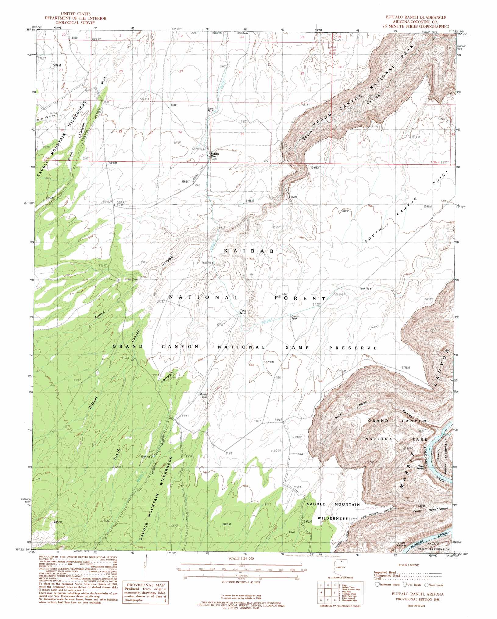
Buffalo Ranch Topo Map Arizona
To zoom in, hover over the map of Buffalo Ranch
USGS Topo Quad 36111d8 - 1:24,000 scale
| Topo Map Name: | Buffalo Ranch |
| USGS Topo Quad ID: | 36111d8 |
| Print Size: | ca. 21 1/4" wide x 27" high |
| Southeast Coordinates: | 36.375° N latitude / 111.875° W longitude |
| Map Center Coordinates: | 36.4375° N latitude / 111.9375° W longitude |
| U.S. State: | AZ |
| Filename: | o36111d8.jpg |
| Download Map JPG Image: | Buffalo Ranch topo map 1:24,000 scale |
| Map Type: | Topographic |
| Topo Series: | 7.5´ |
| Map Scale: | 1:24,000 |
| Source of Map Images: | United States Geological Survey (USGS) |
| Alternate Map Versions: |
Buffalo Ranch AZ 1988, updated 1988 Download PDF Buy paper map Buffalo Ranch AZ 1988, updated 1988 Download PDF Buy paper map Buffalo Ranch AZ 2012 Download PDF Buy paper map Buffalo Ranch AZ 2014 Download PDF Buy paper map |
| FStopo: | US Forest Service topo Buffalo Ranch is available: Download FStopo PDF Download FStopo TIF |
1:24,000 Topo Quads surrounding Buffalo Ranch
Jacob Lake |
House Rock |
Emmett Hill |
Emmett Wash |
Bitter Springs |
Telephone Hill |
Cane |
Buffalo Tanks |
North Canyon Point |
Tanner Well |
De Motte Park |
Dog Point |
Buffalo Ranch |
Tatahatso Point |
Shinumo Altar |
Kanabownits Spring |
Little Park Lake |
Point Imperial |
Nankoweap Mesa |
Blue Moon Reservoir |
Shiva Temple |
Bright Angel Point |
Walhalla Plateau |
Cape Solitude |
Salt Trail Canyon |
> Back to 36111a1 at 1:100,000 scale
> Back to 36110a1 at 1:250,000 scale
> Back to U.S. Topo Maps home
Buffalo Ranch topo map: Gazetteer
Buffalo Ranch: Basins
Triple Alcoves elevation 1181m 3874′Buffalo Ranch: Reservoirs
Burro Tank elevation 1787m 5862′Navajo Tank elevation 1755m 5757′
Tank Number Eight elevation 1683m 5521′
Tank Number Five elevation 1711m 5613′
Tank Number Four elevation 1737m 5698′
Tank Number Six elevation 1736m 5695′
Tank Number Three elevation 1831m 6007′
Buffalo Ranch: Valleys
Bedrock Canyon elevation 1048m 3438′Buck Farm Canyon elevation 878m 2880′
Fence Canyon elevation 1642m 5387′
Tater Canyon elevation 1698m 5570′
Wildcat Canyon elevation 1705m 5593′
Buffalo Ranch digital topo map on disk
Buy this Buffalo Ranch topo map showing relief, roads, GPS coordinates and other geographical features, as a high-resolution digital map file on DVD: