Kaibito Topo Map Arizona
To zoom in, hover over the map of Kaibito
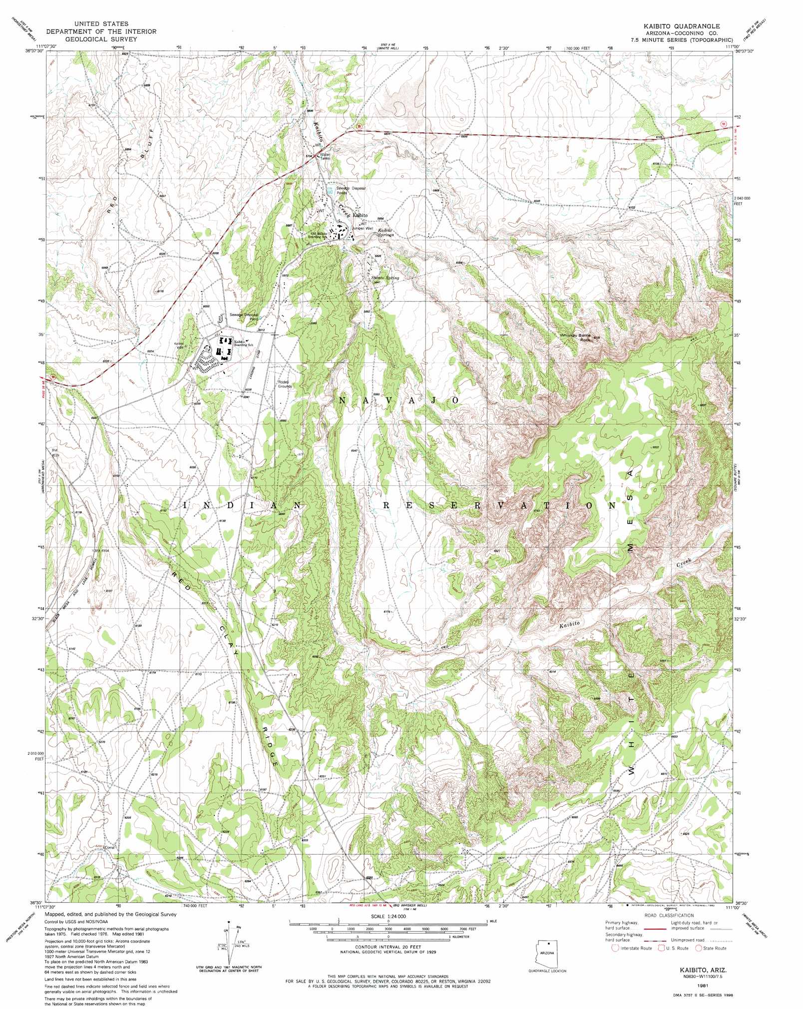
USGS Topo Quad 36111e1 - 1:24,000 scale
| Topo Map Name: | Kaibito |
| USGS Topo Quad ID: | 36111e1 |
| Print Size: | ca. 21 1/4" wide x 27" high |
| Southeast Coordinates: | 36.5° N latitude / 111° W longitude |
| Map Center Coordinates: | 36.5625° N latitude / 111.0625° W longitude |
| U.S. State: | AZ |
| Filename: | o36111e1.jpg |
| Download Map JPG Image: | Kaibito topo map 1:24,000 scale |
| Map Type: | Topographic |
| Topo Series: | 7.5´ |
| Map Scale: | 1:24,000 |
| Source of Map Images: | United States Geological Survey (USGS) |
| Alternate Map Versions: |
Kaibito AZ 1981, updated 1982 Download PDF Buy paper map Kaibito AZ 2011 Download PDF Buy paper map Kaibito AZ 2014 Download PDF Buy paper map |
1:24,000 Topo Quads surrounding Kaibito
Leche-E Rock |
Cedar Tree Bench |
Tse Esgizii |
Chaiyahi Rim Sw |
Chaiyahi Rim Se |
Many Ghosts Hill |
Horsethief Mesa |
White Hill |
Two Red Mesas |
Inscription House Ruin |
Dove Spring Se |
Arrowhead Mesa |
Kaibito |
Square Butte |
Whirlwind Rock |
Sitting Coyote Hill |
Preston Mesa North |
Big Whisker Well |
White Mesa Arch |
Cow Springs |
Preston Well |
Preston Mesa South |
Gopher Spring |
Tonalea |
John Daw Mesa |
> Back to 36111e1 at 1:100,000 scale
> Back to 36110a1 at 1:250,000 scale
> Back to U.S. Topo Maps home
Kaibito topo map: Gazetteer
Kaibito: Airports
Kaibito Airport elevation 1848m 6062′Kaibito: Arches
White Craig Arch elevation 2042m 6699′Kaibito: Populated Places
Kaibito elevation 1771m 5810′Kaibito: Springs
Kaibito Spring elevation 1762m 5780′Shonto Spring elevation 1782m 5846′
Kaibito: Summits
Whiskey Bottle Rock elevation 1982m 6502′Kaibito: Wells
Juniper Well elevation 1750m 5741′Kaibito digital topo map on disk
Buy this Kaibito topo map showing relief, roads, GPS coordinates and other geographical features, as a high-resolution digital map file on DVD: