North Canyon Point Topo Map Arizona
To zoom in, hover over the map of North Canyon Point
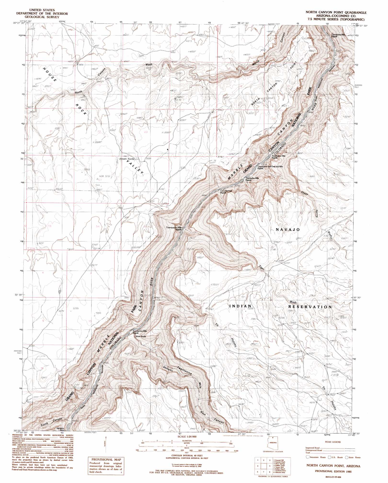
USGS Topo Quad 36111e7 - 1:24,000 scale
| Topo Map Name: | North Canyon Point |
| USGS Topo Quad ID: | 36111e7 |
| Print Size: | ca. 21 1/4" wide x 27" high |
| Southeast Coordinates: | 36.5° N latitude / 111.75° W longitude |
| Map Center Coordinates: | 36.5625° N latitude / 111.8125° W longitude |
| U.S. State: | AZ |
| Filename: | o36111e7.jpg |
| Download Map JPG Image: | North Canyon Point topo map 1:24,000 scale |
| Map Type: | Topographic |
| Topo Series: | 7.5´ |
| Map Scale: | 1:24,000 |
| Source of Map Images: | United States Geological Survey (USGS) |
| Alternate Map Versions: |
North Canyon Point AZ 1985, updated 1985 Download PDF Buy paper map North Canyon Point AZ 2011 Download PDF Buy paper map North Canyon Point AZ 2014 Download PDF Buy paper map |
1:24,000 Topo Quads surrounding North Canyon Point
House Rock Spring |
One Toe Ridge |
The Big Knoll |
Navajo Bridge |
Lees Ferry |
House Rock |
Emmett Hill |
Emmett Wash |
Bitter Springs |
Explosive Rock |
Cane |
Buffalo Tanks |
North Canyon Point |
Tanner Well |
Cedar Tree Hills |
Dog Point |
Buffalo Ranch |
Tatahatso Point |
Shinumo Altar |
Cedar Ridge |
Little Park Lake |
Point Imperial |
Nankoweap Mesa |
Blue Moon Reservoir |
Bodaway Mesa |
> Back to 36111e1 at 1:100,000 scale
> Back to 36110a1 at 1:250,000 scale
> Back to U.S. Topo Maps home
North Canyon Point topo map: Gazetteer
North Canyon Point: Capes
North Canyon Point elevation 1435m 4708′North Canyon Point: Parks
Marble Canyon National Monument (historical) elevation 1308m 4291′North Canyon Point: Rapids
Cave Springs Rapids elevation 891m 2923′Georgie Rapid elevation 896m 2939′
Hansbrough-Richards Rapid elevation 898m 2946′
Twentyfive Mile Rapids elevation 900m 2952′
Twentyfour and One-half Mile Rapids elevation 896m 2939′
Twentynine Mile Rapids elevation 882m 2893′
Twentyone Mile Rapids elevation 914m 2998′
Twentyseven Mile Rapids elevation 886m 2906′
North Canyon Point: Reservoirs
Jensen Tanks elevation 1549m 5082′North Canyon Point: Streams
Roundy Creek elevation 934m 3064′Sheep Spring Wash elevation 903m 2962′
Shinumo Wash elevation 0m 0′
Tiger Wash elevation 948m 3110′
To Hajisho elevation 883m 2896′
North Canyon Point: Valleys
South Canyon elevation 917m 3008′Twentynine Mile Canyon elevation 904m 2965′
North Canyon Point digital topo map on disk
Buy this North Canyon Point topo map showing relief, roads, GPS coordinates and other geographical features, as a high-resolution digital map file on DVD: