Wild Horse Mesa Topo Map Arizona
To zoom in, hover over the map of Wild Horse Mesa
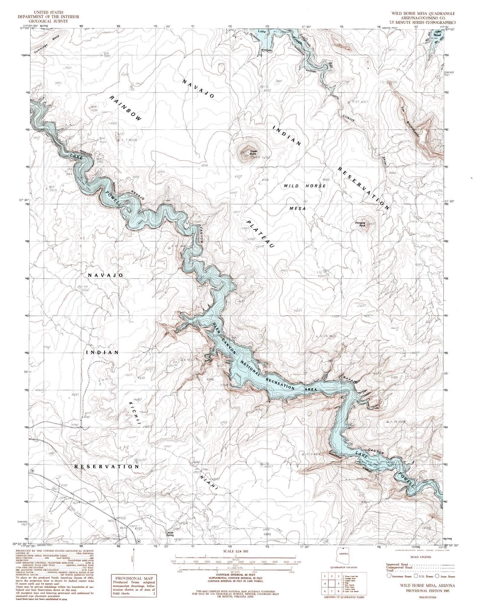
USGS Topo Quad 36111h3 - 1:24,000 scale
| Topo Map Name: | Wild Horse Mesa |
| USGS Topo Quad ID: | 36111h3 |
| Print Size: | ca. 21 1/4" wide x 27" high |
| Southeast Coordinates: | 36.875° N latitude / 111.25° W longitude |
| Map Center Coordinates: | 36.9375° N latitude / 111.3125° W longitude |
| U.S. State: | AZ |
| Filename: | o36111h3.jpg |
| Download Map JPG Image: | Wild Horse Mesa topo map 1:24,000 scale |
| Map Type: | Topographic |
| Topo Series: | 7.5´ |
| Map Scale: | 1:24,000 |
| Source of Map Images: | United States Geological Survey (USGS) |
| Alternate Map Versions: |
Wild Horse Mesa AZ 2011 Download PDF Buy paper map Wild Horse Mesa AZ 2011 Download PDF Buy paper map Wild Horse Mesa AZ 2014 Download PDF Buy paper map |
1:24,000 Topo Quads surrounding Wild Horse Mesa
Tibbet Bench |
Smoky Hollow |
Sit Down Bench |
Mazuki Point |
Navajo Point |
Lone Rock |
Warm Creek Bay |
Gunsight Butte |
Gregory Butte |
Cathedral Canyon |
Ferry Swale |
Page |
Wild Horse Mesa |
Face Canyon |
West Canyon Creek |
Lees Ferry |
White Dome |
Leche-E Rock |
Cedar Tree Bench |
Tse Esgizii |
Explosive Rock |
Dead Monkey Ridge |
Many Ghosts Hill |
Horsethief Mesa |
White Hill |
> Back to 36111e1 at 1:100,000 scale
> Back to 36110a1 at 1:250,000 scale
> Back to U.S. Topo Maps home
Wild Horse Mesa topo map: Gazetteer
Wild Horse Mesa: Arches
Navajo Arch elevation 1153m 3782′Wild Horse Mesa: Parks
Lake Powell Navajo Tribal Park elevation 1230m 4035′Wild Horse Mesa: Pillars
Pinnacle Rock elevation 1433m 4701′Wild Horse Mesa: Summits
Tower Butte elevation 1606m 5269′Wild Horse Mesa elevation 1268m 4160′
Wild Horse Mesa digital topo map on disk
Buy this Wild Horse Mesa topo map showing relief, roads, GPS coordinates and other geographical features, as a high-resolution digital map file on DVD: