Poverty Flat Topo Map Arizona
To zoom in, hover over the map of Poverty Flat
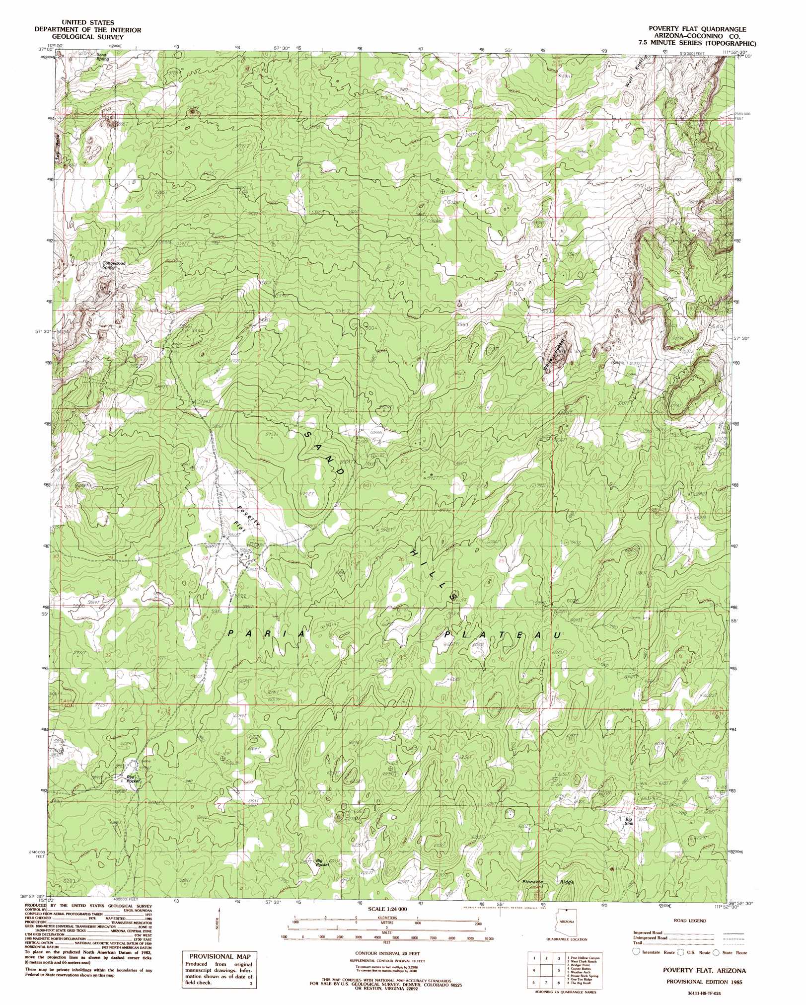
USGS Topo Quad 36111h8 - 1:24,000 scale
| Topo Map Name: | Poverty Flat |
| USGS Topo Quad ID: | 36111h8 |
| Print Size: | ca. 21 1/4" wide x 27" high |
| Southeast Coordinates: | 36.875° N latitude / 111.875° W longitude |
| Map Center Coordinates: | 36.9375° N latitude / 111.9375° W longitude |
| U.S. State: | AZ |
| Filename: | o36111h8.jpg |
| Download Map JPG Image: | Poverty Flat topo map 1:24,000 scale |
| Map Type: | Topographic |
| Topo Series: | 7.5´ |
| Map Scale: | 1:24,000 |
| Source of Map Images: | United States Geological Survey (USGS) |
| Alternate Map Versions: |
Paria Plateau NW AZ 1954, updated 1955 Download PDF Buy paper map Poverty Flat AZ 1985, updated 1985 Download PDF Buy paper map Poverty Flat AZ 2011 Download PDF Buy paper map Poverty Flat AZ 2011 Download PDF Buy paper map Poverty Flat AZ 2014 Download PDF Buy paper map |
1:24,000 Topo Quads surrounding Poverty Flat
Nephi Point |
Eightmile Pass |
Fivemile Valley |
Lower Coyote Spring |
Nipple Butte |
Petrified Hollow |
Pine Hollow Canyon |
West Clark Bench |
Bridger Point |
Glen Canyon City |
Buck Pasture Canyon |
Coyote Buttes |
Poverty Flat |
Wrather Arch |
Water Pockets |
Cooper Ridge |
House Rock Spring |
One Toe Ridge |
The Big Knoll |
Navajo Bridge |
Jacob Lake |
House Rock |
Emmett Hill |
Emmett Wash |
Bitter Springs |
> Back to 36111e1 at 1:100,000 scale
> Back to 36110a1 at 1:250,000 scale
> Back to U.S. Topo Maps home
Poverty Flat topo map: Gazetteer
Poverty Flat: Airports
Sandhill Ranch Airport elevation 1787m 5862′Poverty Flat: Areas
Franks elevation 1763m 5784′Poverty Flat: Basins
Big Pocket elevation 1890m 6200′Big Sink elevation 1864m 6115′
Red Pocket elevation 1835m 6020′
White Pocket elevation 1712m 5616′
Poverty Flat: Summits
Wolf Knoll elevation 1576m 5170′Poverty Flat: Valleys
Black Valley elevation 1788m 5866′Cottonwood Cove elevation 1683m 5521′
Poverty Flat digital topo map on disk
Buy this Poverty Flat topo map showing relief, roads, GPS coordinates and other geographical features, as a high-resolution digital map file on DVD: