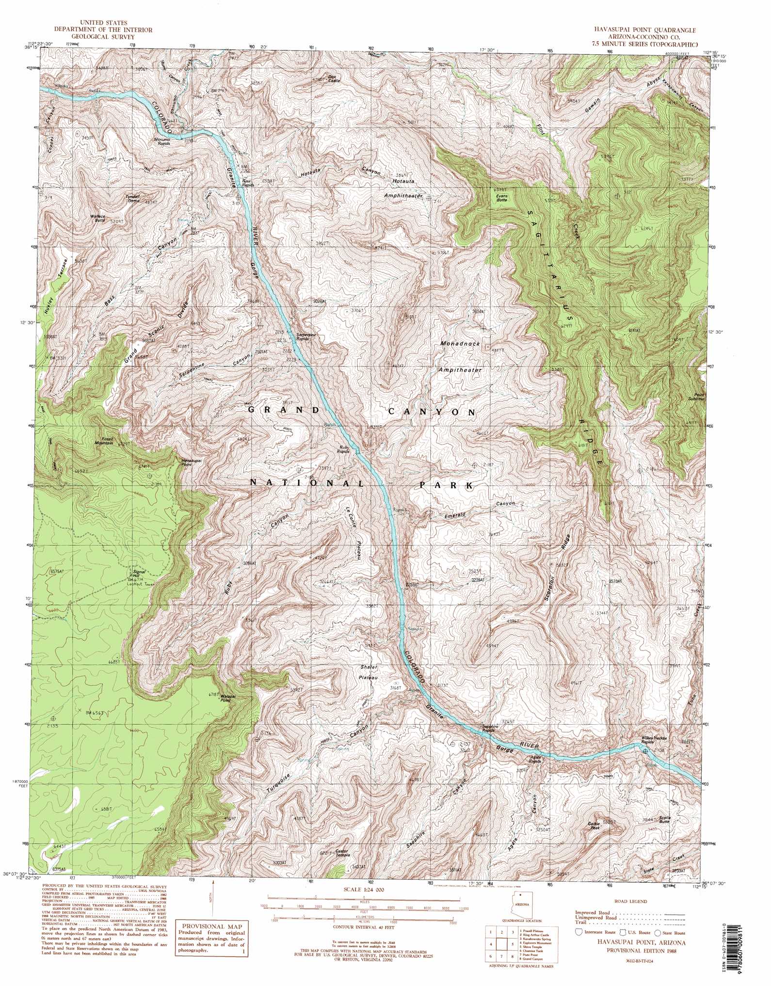
Havasupai Point Topo Map Arizona
To zoom in, hover over the map of Havasupai Point
USGS Topo Quad 36112b3 - 1:24,000 scale
| Topo Map Name: | Havasupai Point |
| USGS Topo Quad ID: | 36112b3 |
| Print Size: | ca. 21 1/4" wide x 27" high |
| Southeast Coordinates: | 36.125° N latitude / 112.25° W longitude |
| Map Center Coordinates: | 36.1875° N latitude / 112.3125° W longitude |
| U.S. State: | AZ |
| Filename: | o36112b3.jpg |
| Download Map JPG Image: | Havasupai Point topo map 1:24,000 scale |
| Map Type: | Topographic |
| Topo Series: | 7.5´ |
| Map Scale: | 1:24,000 |
| Source of Map Images: | United States Geological Survey (USGS) |
| Alternate Map Versions: |
Havasupai Point AZ 1988, updated 1988 Download PDF Buy paper map Havasupai Point AZ 1988, updated 1988 Download PDF Buy paper map Havasupai Point AZ 1988, updated 1988 Download PDF Buy paper map Havasupai Point AZ 2011 Download PDF Buy paper map Havasupai Point AZ 2014 Download PDF Buy paper map |
1:24,000 Topo Quads surrounding Havasupai Point
Fishtail Mesa |
Tapeats Amphitheater |
Timp Point |
De Motte Park |
Dog Point |
Fossil Bay |
Powell Plateau |
King Arthur Castle |
Kanabownits Spring |
Little Park Lake |
Topocoba Hilltop |
Explorers Monument |
Havasupai Point |
Shiva Temple |
Bright Angel Point |
Antelope Point |
Chamisa Tank |
Piute Point |
Grand Canyon |
Phantom Ranch |
Baldy Basin |
Box K Ranch |
Metzger Tank |
Tusayan West |
Tusayan East |
> Back to 36112a1 at 1:100,000 scale
> Back to 36112a1 at 1:250,000 scale
> Back to U.S. Topo Maps home
Havasupai Point topo map: Gazetteer
Havasupai Point: Basins
Hotauta Amphitheater elevation 1179m 3868′Monadnock Amphitheater elevation 1129m 3704′
Havasupai Point: Capes
Point Sublime elevation 2192m 7191′Havasupai Point: Cliffs
Havasupai Point elevation 2066m 6778′Walapai Point elevation 2043m 6702′
Havasupai Point: Plains
Huxley Terrace elevation 1705m 5593′Le Conte Plateau elevation 1424m 4671′
Shaler Plateau elevation 0m 0′
Havasupai Point: Rapids
Agate Rapids elevation 691m 2267′Bass Rapids elevation 700m 2296′
Emerald Rapid elevation 684m 2244′
Ruby Rapid elevation 682m 2237′
Rudy Rapids elevation 682m 2237′
Sapphire Rapids elevation 690m 2263′
Serpentine Rapids elevation 0m 0′
Shinumo Rapids elevation 0m 0′
Willies Necktie Rapids elevation 694m 2276′
Havasupai Point: Ridges
Grand Scenic Divide elevation 1687m 5534′Sagittarius Ridge elevation 0m 0′
Scorpion Ridge elevation 0m 0′
Havasupai Point: Streams
Flint Creek elevation 939m 3080′Shinumo Creek elevation 0m 0′
Tuna Creek elevation 700m 2296′
Havasupai Point: Summits
Castor Temple elevation 1896m 6220′Charybdis Butte elevation 842m 2762′
Dox Castle elevation 1407m 4616′
Evans Butte elevation 1938m 6358′
Fossil Mountain elevation 1994m 6541′
Geikie Peak elevation 1506m 4940′
Scylla Butte elevation 0m 0′
Signal Hill elevation 0m 0′
Tyndall Dome elevation 1414m 4639′
Wallace Butte elevation 1543m 5062′
Havasupai Point: Valleys
Agate Canyon elevation 807m 2647′Bass Canyon elevation 746m 2447′
Burro Canyon elevation 790m 2591′
Copper Canyon elevation 787m 2582′
Emerald Canyon elevation 697m 2286′
Gawain Abyss elevation 1163m 3815′
Hotauta Canyon elevation 714m 2342′
Kanabownits Canyon elevation 1350m 4429′
Ruby Canyon elevation 0m 0′
Sapphire Canyon elevation 0m 0′
Serpentine Canyon elevation 0m 0′
Turquoise Canyon elevation 707m 2319′
Havasupai Point digital topo map on disk
Buy this Havasupai Point topo map showing relief, roads, GPS coordinates and other geographical features, as a high-resolution digital map file on DVD: