King Arthur Castle Topo Map Arizona
To zoom in, hover over the map of King Arthur Castle
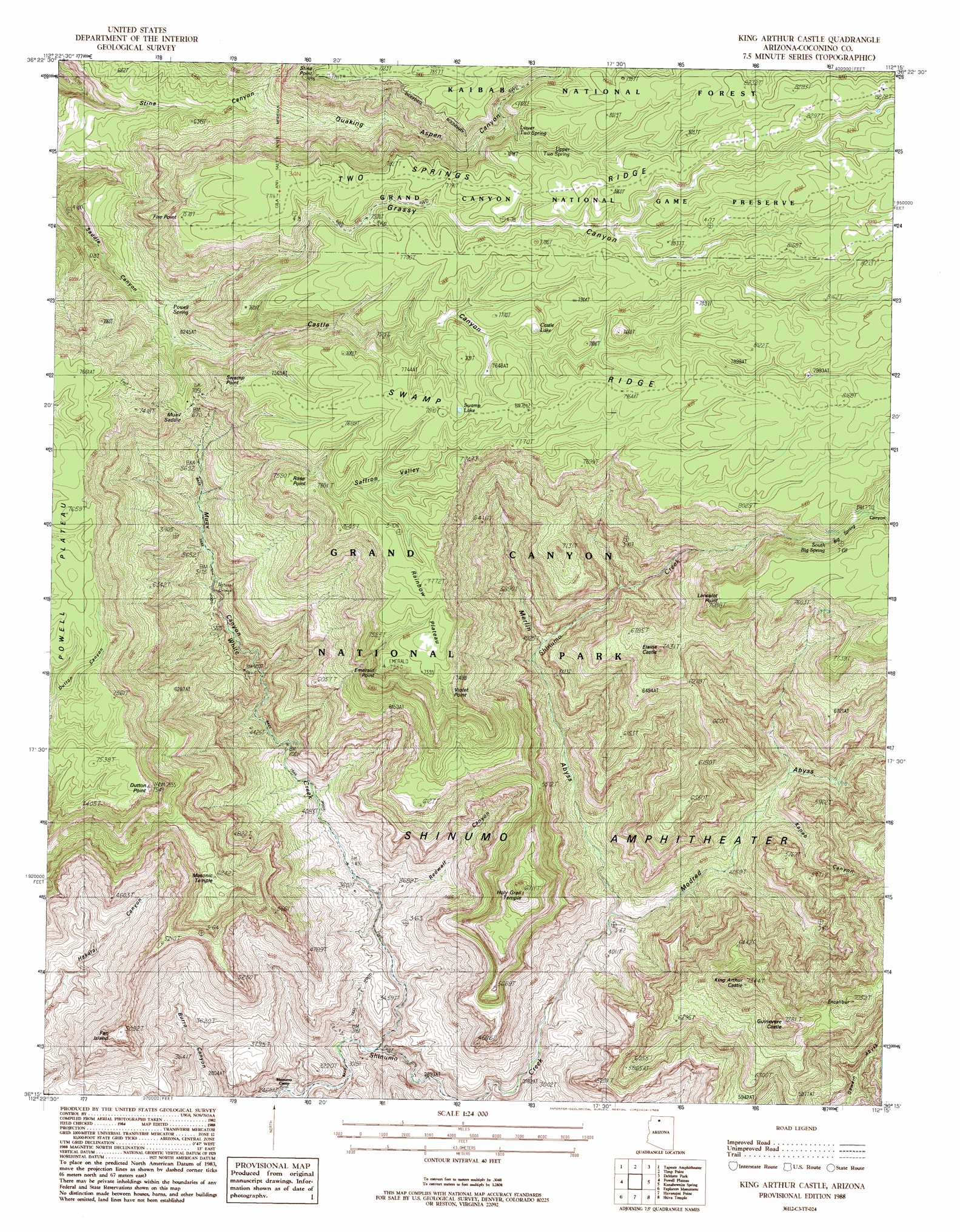
USGS Topo Quad 36112c3 - 1:24,000 scale
| Topo Map Name: | King Arthur Castle |
| USGS Topo Quad ID: | 36112c3 |
| Print Size: | ca. 21 1/4" wide x 27" high |
| Southeast Coordinates: | 36.25° N latitude / 112.25° W longitude |
| Map Center Coordinates: | 36.3125° N latitude / 112.3125° W longitude |
| U.S. State: | AZ |
| Filename: | o36112c3.jpg |
| Download Map JPG Image: | King Arthur Castle topo map 1:24,000 scale |
| Map Type: | Topographic |
| Topo Series: | 7.5´ |
| Map Scale: | 1:24,000 |
| Source of Map Images: | United States Geological Survey (USGS) |
| Alternate Map Versions: |
King Arthur Castle AZ 1988, updated 1988 Download PDF Buy paper map King Arthur Castle AZ 1988, updated 1988 Download PDF Buy paper map King Arthur Castle AZ 2012 Download PDF Buy paper map King Arthur Castle AZ 2014 Download PDF Buy paper map |
| FStopo: | US Forest Service topo King Arthur Castle is available: Download FStopo PDF Download FStopo TIF |
1:24,000 Topo Quads surrounding King Arthur Castle
Jumpup Point |
Sowats Spring |
Big Springs |
Telephone Hill |
Cane |
Fishtail Mesa |
Tapeats Amphitheater |
Timp Point |
De Motte Park |
Dog Point |
Fossil Bay |
Powell Plateau |
King Arthur Castle |
Kanabownits Spring |
Little Park Lake |
Topocoba Hilltop |
Explorers Monument |
Havasupai Point |
Shiva Temple |
Bright Angel Point |
Antelope Point |
Chamisa Tank |
Piute Point |
Grand Canyon |
Phantom Ranch |
> Back to 36112a1 at 1:100,000 scale
> Back to 36112a1 at 1:250,000 scale
> Back to U.S. Topo Maps home
King Arthur Castle topo map: Gazetteer
King Arthur Castle: Capes
Beaman Point elevation 2395m 7857′King Arthur Castle: Cliffs
Dutton Point elevation 2299m 7542′Emerald Point elevation 2270m 7447′
Fire Point elevation 2121m 6958′
Galahad Point elevation 2296m 7532′
Lancelot Point elevation 2437m 7995′
Rose Point elevation 2312m 7585′
Stina Point elevation 2140m 7020′
Swamp Point elevation 2110m 6922′
Violet Point elevation 2269m 7444′
King Arthur Castle: Gaps
Muav Saddle elevation 2077m 6814′King Arthur Castle: Lakes
Castle Lake elevation 2323m 7621′Swamp Lake elevation 2363m 7752′
King Arthur Castle: Plains
Rainbow Plateau elevation 2362m 7749′King Arthur Castle: Ridges
Swamp Ridge elevation 2438m 7998′Two Springs Ridge elevation 2432m 7979′
King Arthur Castle: Springs
Ikes Spring elevation 2422m 7946′Lower Two Spring elevation 2292m 7519′
Powell Spring elevation 1901m 6236′
South Big Spring elevation 2311m 7582′
Upper Two Spring elevation 2377m 7798′
King Arthur Castle: Streams
White Creek elevation 842m 2762′King Arthur Castle: Summits
Elaine Castle elevation 2232m 7322′Excalibur elevation 2097m 6879′
Fan Island elevation 1553m 5095′
Guinevere Castle elevation 2203m 7227′
Holy Grail Temple elevation 1983m 6505′
King Arthur Castle elevation 2222m 7290′
Masonic Temple elevation 1884m 6181′
King Arthur Castle: Trails
Bass Trail elevation 1070m 3510′King Arthur Castle: Valleys
Big Spring Canyon elevation 2340m 7677′Castle Canyon elevation 1908m 6259′
Grass Canyon elevation 1919m 6295′
Merlin Abyss elevation 1166m 3825′
Modred Abyss elevation 1126m 3694′
Muav Canyon elevation 1004m 3293′
Quaking Aspen Canyon elevation 1913m 6276′
Redwall Canyon elevation 1045m 3428′
Saffron Valley elevation 0m 0′
King Arthur Castle digital topo map on disk
Buy this King Arthur Castle topo map showing relief, roads, GPS coordinates and other geographical features, as a high-resolution digital map file on DVD: