De Motte Park Topo Map Arizona
To zoom in, hover over the map of De Motte Park
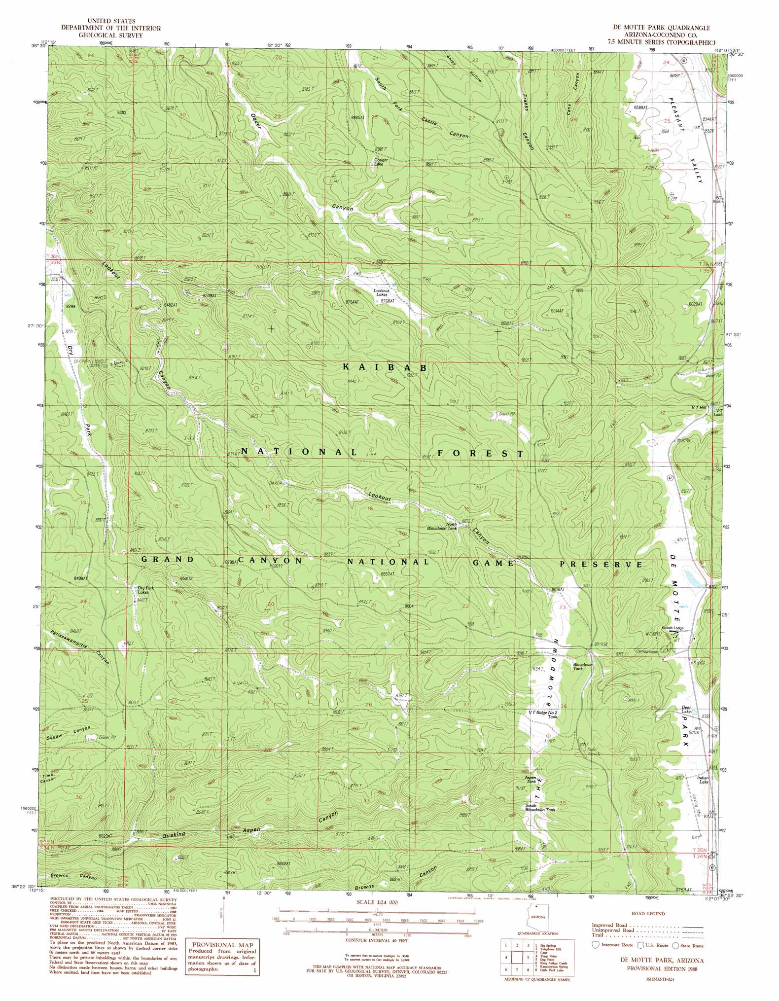
USGS Topo Quad 36112d2 - 1:24,000 scale
| Topo Map Name: | De Motte Park |
| USGS Topo Quad ID: | 36112d2 |
| Print Size: | ca. 21 1/4" wide x 27" high |
| Southeast Coordinates: | 36.375° N latitude / 112.125° W longitude |
| Map Center Coordinates: | 36.4375° N latitude / 112.1875° W longitude |
| U.S. State: | AZ |
| Filename: | o36112d2.jpg |
| Download Map JPG Image: | De Motte Park topo map 1:24,000 scale |
| Map Type: | Topographic |
| Topo Series: | 7.5´ |
| Map Scale: | 1:24,000 |
| Source of Map Images: | United States Geological Survey (USGS) |
| Alternate Map Versions: |
De Motte Park AZ 1988, updated 1988 Download PDF Buy paper map De Motte Park AZ 1988, updated 1988 Download PDF Buy paper map De Motte Park AZ 2012 Download PDF Buy paper map De Motte Park AZ 2014 Download PDF Buy paper map |
| FStopo: | US Forest Service topo De Motte Park is available: Download FStopo PDF Download FStopo TIF |
1:24,000 Topo Quads surrounding De Motte Park
Toothpick Ridge |
Warm Springs Canyon |
Jacob Lake |
House Rock |
Emmett Hill |
Sowats Spring |
Big Springs |
Telephone Hill |
Cane |
Buffalo Tanks |
Tapeats Amphitheater |
Timp Point |
De Motte Park |
Dog Point |
Buffalo Ranch |
Powell Plateau |
King Arthur Castle |
Kanabownits Spring |
Little Park Lake |
Point Imperial |
Explorers Monument |
Havasupai Point |
Shiva Temple |
Bright Angel Point |
Walhalla Plateau |
> Back to 36112a1 at 1:100,000 scale
> Back to 36112a1 at 1:250,000 scale
> Back to U.S. Topo Maps home
De Motte Park topo map: Gazetteer
De Motte Park: Airports
V T Park Landing Strip elevation 2664m 8740′De Motte Park: Areas
The Blowdown elevation 2783m 9130′De Motte Park: Flats
De Motte Park elevation 2665m 8743′Dry Park elevation 2533m 8310′
De Motte Park: Lakes
Cougar Lake elevation 2669m 8756′Deer Lake elevation 2657m 8717′
Dry Park Lakes elevation 2573m 8441′
Indian Lake elevation 2657m 8717′
Lookout Lakes elevation 2673m 8769′
V T Lake elevation 2689m 8822′
De Motte Park: Reservoirs
Aspen Tank elevation 2753m 9032′Blow Down Tank elevation 2683m 8802′
Blowdown Tank elevation 2779m 9117′
Browns Canyon Tank elevation 2466m 8090′
North Blow Down Tank elevation 2707m 8881′
South Blow Down Tank elevation 2715m 8907′
V T Ridge Number One Tank elevation 2798m 9179′
V T Ridge Number Two Tank elevation 2778m 9114′
West Blow Down Tank elevation 2709m 8887′
De Motte Park: Summits
V T Hill elevation 2705m 8874′De Motte Park digital topo map on disk
Buy this De Motte Park topo map showing relief, roads, GPS coordinates and other geographical features, as a high-resolution digital map file on DVD: