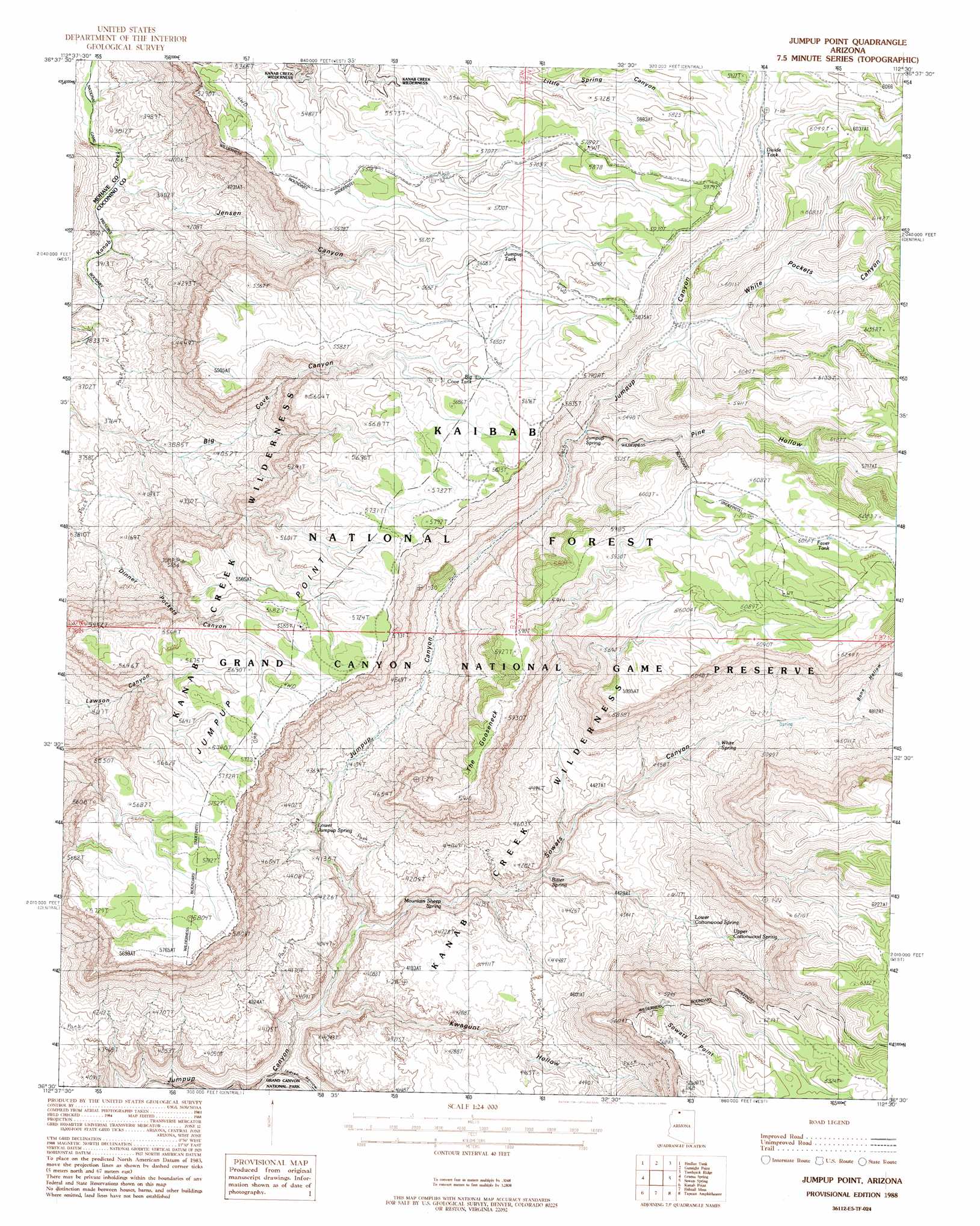
Jumpup Point Topo Map Arizona
To zoom in, hover over the map of Jumpup Point
USGS Topo Quad 36112e5 - 1:24,000 scale
| Topo Map Name: | Jumpup Point |
| USGS Topo Quad ID: | 36112e5 |
| Print Size: | ca. 21 1/4" wide x 27" high |
| Southeast Coordinates: | 36.5° N latitude / 112.5° W longitude |
| Map Center Coordinates: | 36.5625° N latitude / 112.5625° W longitude |
| U.S. State: | AZ |
| Filename: | o36112e5.jpg |
| Download Map JPG Image: | Jumpup Point topo map 1:24,000 scale |
| Map Type: | Topographic |
| Topo Series: | 7.5´ |
| Map Scale: | 1:24,000 |
| Source of Map Images: | United States Geological Survey (USGS) |
| Alternate Map Versions: |
Jumpup Point AZ 1988, updated 1988 Download PDF Buy paper map Jumpup Point AZ 1988, updated 1988 Download PDF Buy paper map Jumpup Point AZ 2012 Download PDF Buy paper map Jumpup Point AZ 2014 Download PDF Buy paper map |
| FStopo: | US Forest Service topo Jumpup Point is available: Download FStopo PDF Download FStopo TIF |
1:24,000 Topo Quads surrounding Jumpup Point
Pipe Valley |
Pipe Spring |
Clear Water Spring |
White Sage Flat |
Le Fevre Ridge |
Sunshine Ridge |
Findlay Tank |
Gunsight Point |
Toothpick Ridge |
Warm Springs Canyon |
Robinson Canyon |
Grama Spring |
Jumpup Point |
Sowats Spring |
Big Springs |
Hitson Tank |
Kanab Point |
Fishtail Mesa |
Tapeats Amphitheater |
Timp Point |
S B Point |
Havasu Falls |
Fossil Bay |
Powell Plateau |
King Arthur Castle |
> Back to 36112e1 at 1:100,000 scale
> Back to 36112a1 at 1:250,000 scale
> Back to U.S. Topo Maps home
Jumpup Point topo map: Gazetteer
Jumpup Point: Bends
The Gooseneck elevation 1799m 5902′Jumpup Point: Cliffs
Jumpup Point elevation 1734m 5688′Sowats Point elevation 1810m 5938′
Jumpup Point: Reservoirs
Big Cove Tank elevation 1709m 5606′Dinner Pockets Trick Tank elevation 1721m 5646′
Divide Tank elevation 1752m 5748′
Faver Tank elevation 1866m 6122′
Goose Neck Trick Tank elevation 1868m 6128′
Jensen Trick Tank elevation 1729m 5672′
Jumpup Tank elevation 1723m 5652′
Jumpup Trick Tank elevation 1745m 5725′
Little Spring Tank elevation 1752m 5748′
Little Spring Trick Tank elevation 1763m 5784′
Jumpup Point: Springs
Bitter Spring elevation 1206m 3956′Box Elder Spring elevation 1399m 4589′
Cottonwood Spring elevation 1284m 4212′
Jumpup Spring elevation 1546m 5072′
Lower Cottonwood Spring elevation 1402m 4599′
Lower Jumpup Spring elevation 1241m 4071′
Mountain Sheep Spring elevation 1140m 3740′
Upper Cottonwood Spring elevation 1462m 4796′
White Spring elevation 1380m 4527′
Jumpup Point: Valleys
Bone Hollow elevation 1467m 4812′Indian Hollow elevation 1024m 3359′
Jensen Canyon elevation 1127m 3697′
Kwagunt Hollow elevation 1021m 3349′
Pine Hollow elevation 1553m 5095′
Sowats Canyon elevation 1073m 3520′
White Pockets Canyon elevation 1647m 5403′
Jumpup Point digital topo map on disk
Buy this Jumpup Point topo map showing relief, roads, GPS coordinates and other geographical features, as a high-resolution digital map file on DVD: