Jacob Lake Topo Map Arizona
To zoom in, hover over the map of Jacob Lake
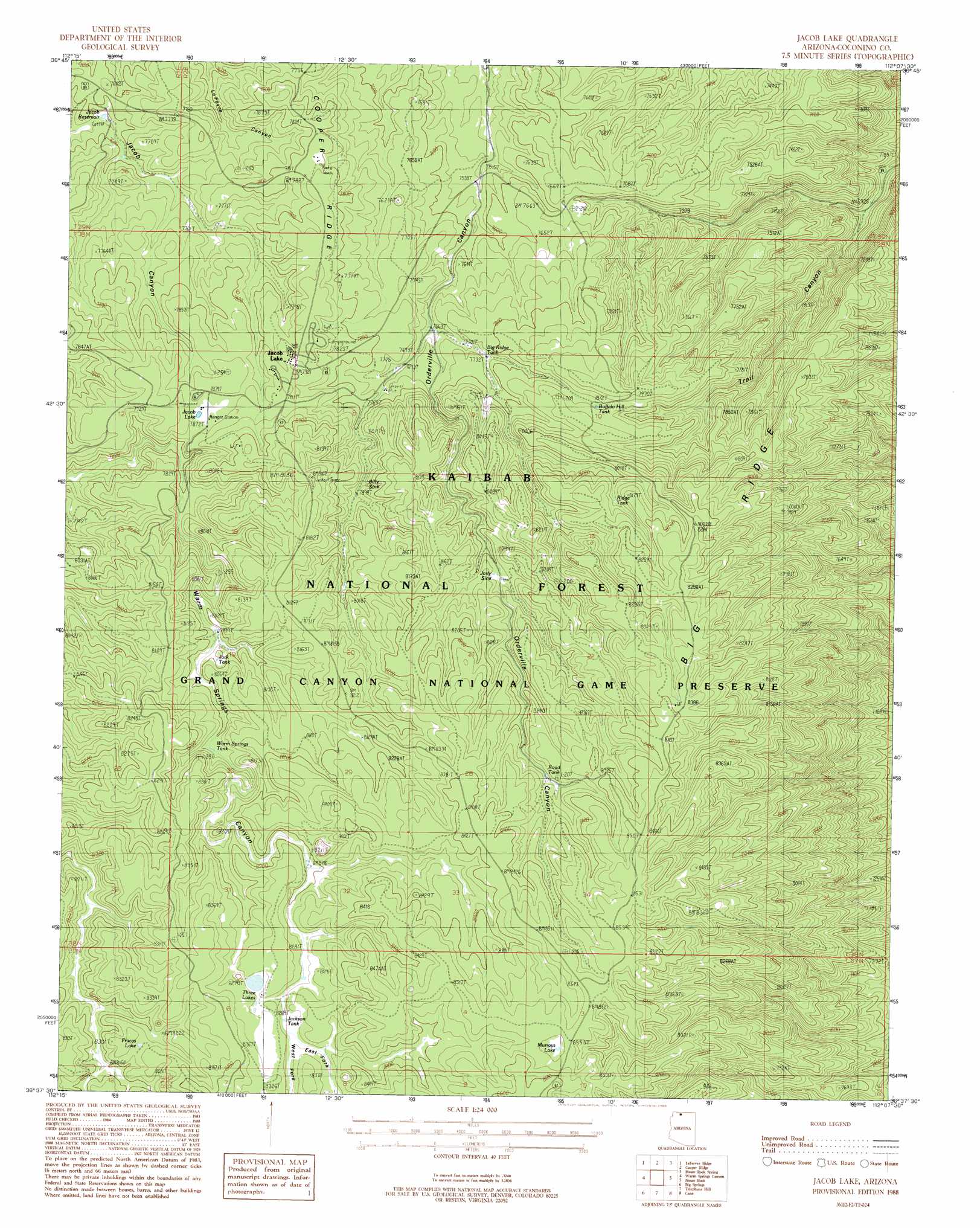
USGS Topo Quad 36112f2 - 1:24,000 scale
| Topo Map Name: | Jacob Lake |
| USGS Topo Quad ID: | 36112f2 |
| Print Size: | ca. 21 1/4" wide x 27" high |
| Southeast Coordinates: | 36.625° N latitude / 112.125° W longitude |
| Map Center Coordinates: | 36.6875° N latitude / 112.1875° W longitude |
| U.S. State: | AZ |
| Filename: | o36112f2.jpg |
| Download Map JPG Image: | Jacob Lake topo map 1:24,000 scale |
| Map Type: | Topographic |
| Topo Series: | 7.5´ |
| Map Scale: | 1:24,000 |
| Source of Map Images: | United States Geological Survey (USGS) |
| Alternate Map Versions: |
Jacob Lake AZ 1988, updated 1988 Download PDF Buy paper map Jacob Lake AZ 1988, updated 1988 Download PDF Buy paper map Jacob Lake AZ 2012 Download PDF Buy paper map Jacob Lake AZ 2014 Download PDF Buy paper map |
| FStopo: | US Forest Service topo Jacob Lake is available: Download FStopo PDF Download FStopo TIF |
1:24,000 Topo Quads surrounding Jacob Lake
Shinarump Point |
Muggins Flat |
Buck Pasture Canyon |
Coyote Buttes |
Poverty Flat |
White Sage Flat |
Le Fevre Ridge |
Cooper Ridge |
House Rock Spring |
One Toe Ridge |
Toothpick Ridge |
Warm Springs Canyon |
Jacob Lake |
House Rock |
Emmett Hill |
Sowats Spring |
Big Springs |
Telephone Hill |
Cane |
Buffalo Tanks |
Tapeats Amphitheater |
Timp Point |
De Motte Park |
Dog Point |
Buffalo Ranch |
> Back to 36112e1 at 1:100,000 scale
> Back to 36112a1 at 1:250,000 scale
> Back to U.S. Topo Maps home
Jacob Lake topo map: Gazetteer
Jacob Lake: Basins
Billy Sink elevation 2404m 7887′Jolly Sink elevation 2450m 8038′
Jacob Lake: Lakes
Fracas Lake elevation 2522m 8274′Jacob Lake elevation 2400m 7874′
Murrays Lake elevation 2598m 8523′
Three Lakes elevation 2525m 8284′
Jacob Lake: Populated Places
Jacob Lake elevation 2417m 7929′Jacob Lake: Reservoirs
Big Ridge Apron elevation 2499m 8198′Big Ridge Tank elevation 2362m 7749′
Bridge Tank elevation 2293m 7522′
Buffalo Hill Tank elevation 2402m 7880′
Buffalo Trick Tank elevation 2555m 8382′
Highway Yard Tank elevation 2382m 7814′
Holding Pasture Tank elevation 2363m 7752′
Jack Tank elevation 2438m 7998′
Jackson Tank elevation 2517m 8257′
Jacob Reservoir elevation 2304m 7559′
Jolly Sink Road Tank elevation 2524m 8280′
Ridge Tank elevation 2456m 8057′
Rollys Tank elevation 2539m 8330′
RV Tank elevation 2389m 7837′
Sorenson Tank elevation 2354m 7723′
Two Six Two Tank Number 2 elevation 2489m 8166′
Two Six Two Tank Number One elevation 2510m 8234′
Warm Springs Tank elevation 2448m 8031′
Jacob Lake: Ridges
Big Ridge elevation 2427m 7962′Jacob Lake: Valleys
East Fork Warm Springs Canyon elevation 2524m 8280′West Fork Warm Springs Canyon elevation 2524m 8280′
Jacob Lake digital topo map on disk
Buy this Jacob Lake topo map showing relief, roads, GPS coordinates and other geographical features, as a high-resolution digital map file on DVD: