Whitmore Point Topo Map Arizona
To zoom in, hover over the map of Whitmore Point
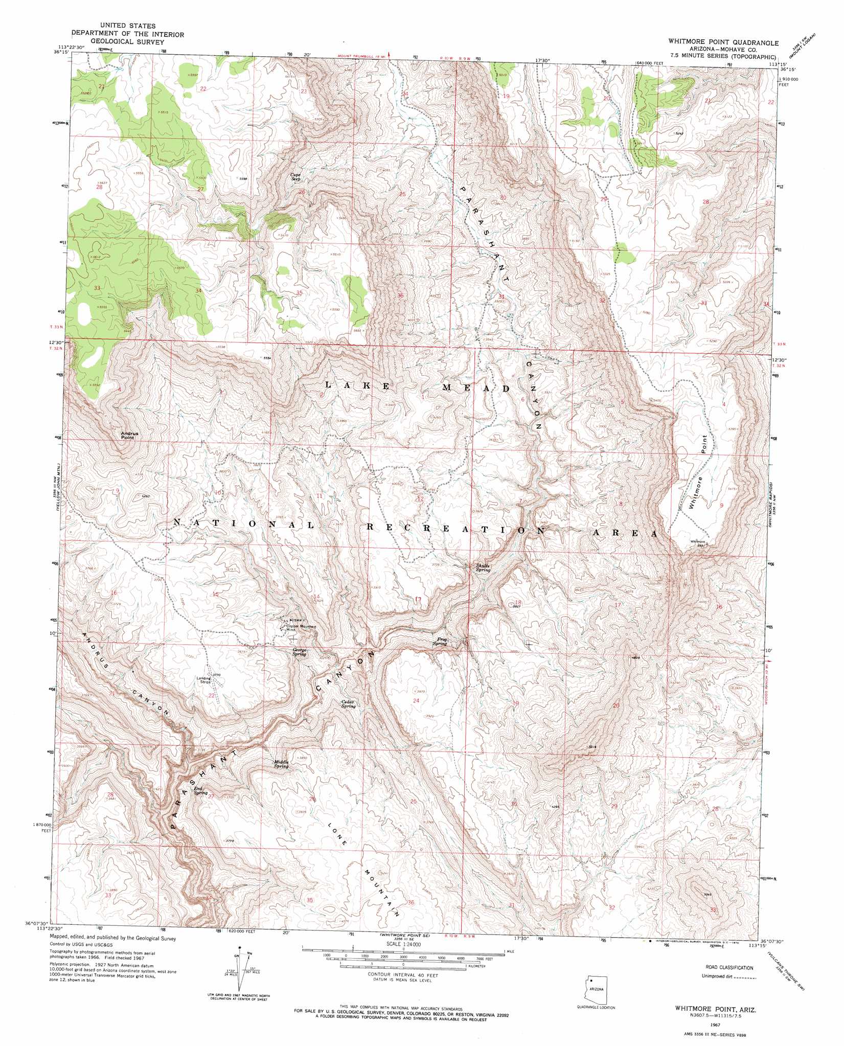
USGS Topo Quad 36113b3 - 1:24,000 scale
| Topo Map Name: | Whitmore Point |
| USGS Topo Quad ID: | 36113b3 |
| Print Size: | ca. 21 1/4" wide x 27" high |
| Southeast Coordinates: | 36.125° N latitude / 113.25° W longitude |
| Map Center Coordinates: | 36.1875° N latitude / 113.3125° W longitude |
| U.S. State: | AZ |
| Filename: | o36113b3.jpg |
| Download Map JPG Image: | Whitmore Point topo map 1:24,000 scale |
| Map Type: | Topographic |
| Topo Series: | 7.5´ |
| Map Scale: | 1:24,000 |
| Source of Map Images: | United States Geological Survey (USGS) |
| Alternate Map Versions: |
Whitmore Point AZ 1967, updated 1970 Download PDF Buy paper map Whitmore Point AZ 2011 Download PDF Buy paper map Whitmore Point AZ 2014 Download PDF Buy paper map |
1:24,000 Topo Quads surrounding Whitmore Point
Poverty Spring |
Poverty Knoll |
Jones Hill |
Mount Trumbull |
Mount Trumbull Ne |
Wildcat Ranch |
Grassy Mountain |
Cold Spring |
Mount Logan |
Mount Trumbull Se |
Castle Peak |
Yellow John Mountain |
Whitmore Point |
Whitmore Rapids |
Vulcans Throne |
Mount Dellenbaugh |
Whitmore Point Sw |
Whitmore Point Se |
Vulcans Throne Sw |
Vulcans Throne Se |
Amos Point |
Price Point |
Granite Park |
Hockey Puck Spring |
Prospect Point |
> Back to 36113a1 at 1:100,000 scale
> Back to 36112a1 at 1:250,000 scale
> Back to U.S. Topo Maps home
Whitmore Point topo map: Gazetteer
Whitmore Point: Cliffs
Whitmore Point elevation 1654m 5426′Whitmore Point: Dams
Keyhole Dam elevation 1061m 3480′Whitmore Point: Mines
Copper Mountain Mine elevation 1044m 3425′Whitmore Point: Reservoirs
Chefs Pond elevation 1073m 3520′Grassie Point Reservoir elevation 1650m 5413′
Iverson Tank elevation 1100m 3608′
Show Pockets Tank elevation 1114m 3654′
Slick Rock Tank elevation 1054m 3458′
Whitmore Point: Springs
Cedar Spring elevation 902m 2959′Cupe Seep elevation 1263m 4143′
End Spring elevation 963m 3159′
Frog Spring elevation 986m 3234′
George Spring elevation 900m 2952′
Georges Spring elevation 916m 3005′
Middle Spring elevation 1004m 3293′
Shults Spring elevation 0m 0′
Whitmore Point: Summits
Andrus Point elevation 1650m 5413′Lone Mountain elevation 1291m 4235′
Whitmore Point: Valleys
Andrus Canyon elevation 736m 2414′Whitmore Point digital topo map on disk
Buy this Whitmore Point topo map showing relief, roads, GPS coordinates and other geographical features, as a high-resolution digital map file on DVD: