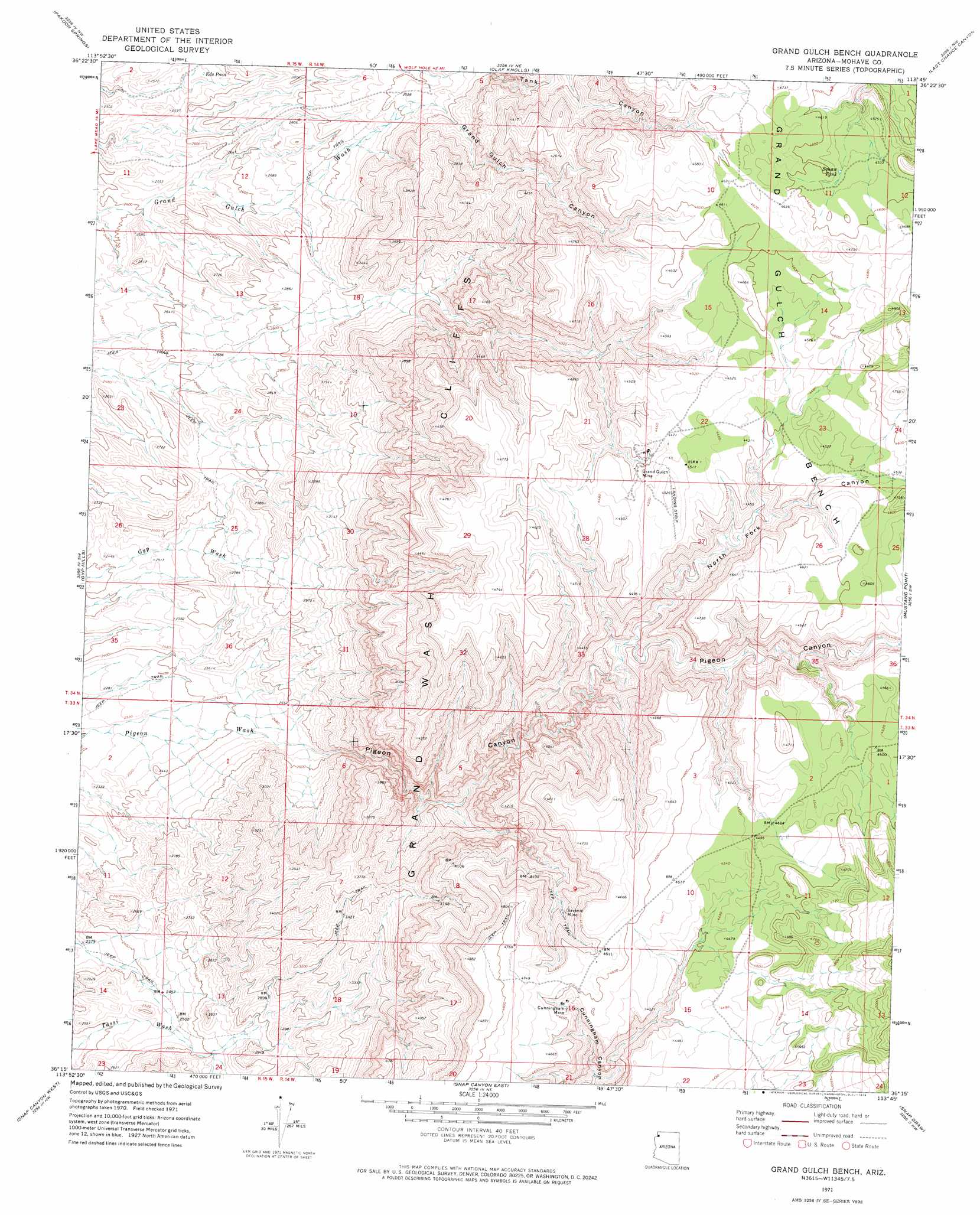
Grand Gulch Bench Topo Map Arizona
To zoom in, hover over the map of Grand Gulch Bench
USGS Topo Quad 36113c7 - 1:24,000 scale
| Topo Map Name: | Grand Gulch Bench |
| USGS Topo Quad ID: | 36113c7 |
| Print Size: | ca. 21 1/4" wide x 27" high |
| Southeast Coordinates: | 36.25° N latitude / 113.75° W longitude |
| Map Center Coordinates: | 36.3125° N latitude / 113.8125° W longitude |
| U.S. State: | AZ |
| Filename: | o36113c7.jpg |
| Download Map JPG Image: | Grand Gulch Bench topo map 1:24,000 scale |
| Map Type: | Topographic |
| Topo Series: | 7.5´ |
| Map Scale: | 1:24,000 |
| Source of Map Images: | United States Geological Survey (USGS) |
| Alternate Map Versions: |
Grand Gulch Bench AZ 1971, updated 1974 Download PDF Buy paper map Grand Gulch Bench AZ 2011 Download PDF Buy paper map Grand Gulch Bench AZ 2014 Download PDF Buy paper map |
1:24,000 Topo Quads surrounding Grand Gulch Bench
Virgin Peak |
Red Pockets |
Cane Springs Se |
Saint George Canyon |
Sullivan Draw South |
Saint Thomas Gap |
Pakoon Springs |
Olaf Knolls |
Last Chance Canyon |
Poverty Spring |
Azure Ridge |
Gyp Hills |
Grand Gulch Bench |
Mustang Point |
Wildcat Ranch |
Iceberg Canyon |
Snap Canyon West |
Snap Canyon East |
Snap Draw |
Castle Peak |
Meadview North |
Columbine Falls |
Bat Cave |
Tincanebitts Point |
Mount Dellenbaugh |
> Back to 36113a1 at 1:100,000 scale
> Back to 36112a1 at 1:250,000 scale
> Back to U.S. Topo Maps home
Grand Gulch Bench topo map: Gazetteer
Grand Gulch Bench: Benches
Grand Gulch Bench elevation 1366m 4481′Grand Gulch Bench: Lakes
Eds Pond elevation 768m 2519′Grand Gulch Bench: Mines
Cunningham Mine elevation 1367m 4484′Grand Gulch Mine elevation 1349m 4425′
Savanic Mine elevation 0m 0′
Grand Gulch Bench: Reservoirs
Squaw Tank elevation 1380m 4527′Grand Gulch Bench: Valleys
Grand Gulch Canyon elevation 915m 3001′North Fork Canyon elevation 1138m 3733′
Pigeon Canyon elevation 768m 2519′
Grand Gulch Bench digital topo map on disk
Buy this Grand Gulch Bench topo map showing relief, roads, GPS coordinates and other geographical features, as a high-resolution digital map file on DVD: