The Grandstand Topo Map Arizona
To zoom in, hover over the map of The Grandstand
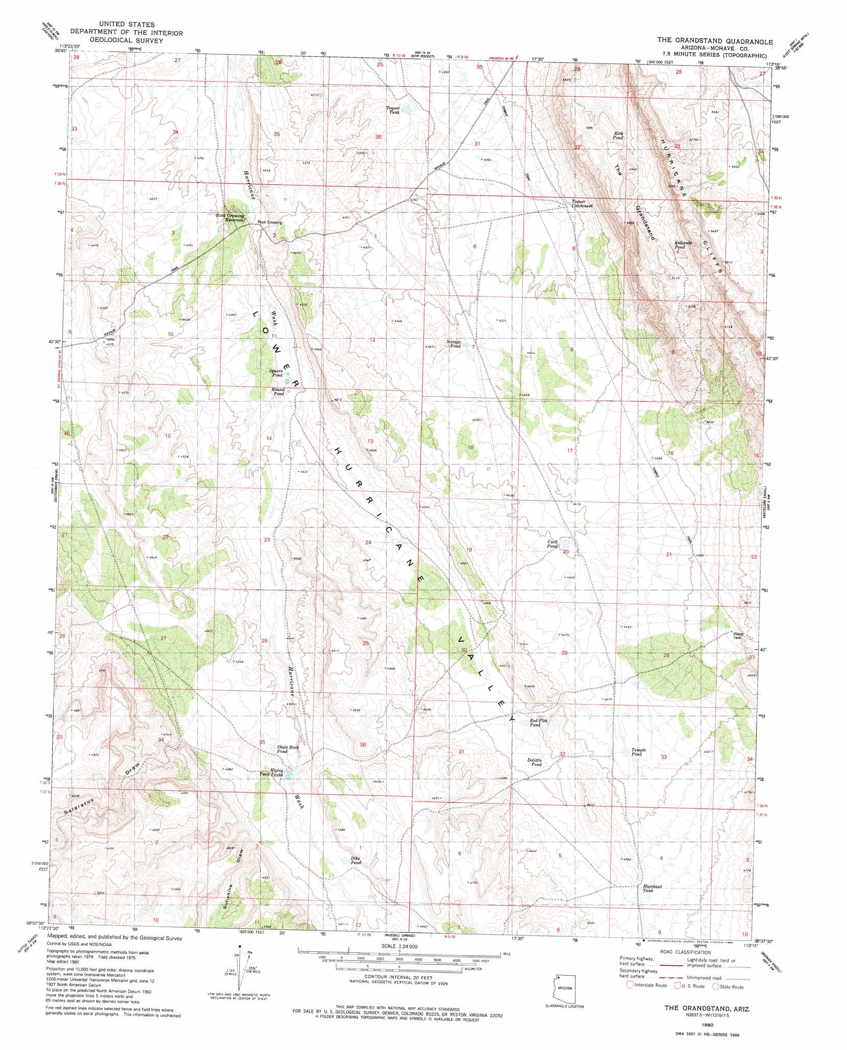
USGS Topo Quad 36113f3 - 1:24,000 scale
| Topo Map Name: | The Grandstand |
| USGS Topo Quad ID: | 36113f3 |
| Print Size: | ca. 21 1/4" wide x 27" high |
| Southeast Coordinates: | 36.625° N latitude / 113.25° W longitude |
| Map Center Coordinates: | 36.6875° N latitude / 113.3125° W longitude |
| U.S. State: | AZ |
| Filename: | o36113f3.jpg |
| Download Map JPG Image: | The Grandstand topo map 1:24,000 scale |
| Map Type: | Topographic |
| Topo Series: | 7.5´ |
| Map Scale: | 1:24,000 |
| Source of Map Images: | United States Geological Survey (USGS) |
| Alternate Map Versions: |
The Grandstand AZ 1980, updated 1980 Download PDF Buy paper map The Grandstand AZ 2011 Download PDF Buy paper map The Grandstand AZ 2014 Download PDF Buy paper map |
1:24,000 Topo Quads surrounding The Grandstand
Lizard Point |
Yellowhorse Flat |
Rock Canyon |
Lost Spring Mountain West |
Lost Spring Mountain East |
Wolf Hole Mountain East |
Hole-N-Wall Canyon |
Gyp Pocket |
White Pockets |
Formaster Well |
Sullivan Draw North |
Dutchman Draw |
The Grandstand |
Antelope Knoll |
Little Clayhole Valley |
Sullivan Draw South |
Little Tanks |
Russell Spring |
Moriah Knoll |
Hat Knoll |
Poverty Spring |
Poverty Knoll |
Jones Hill |
Mount Trumbull |
Mount Trumbull Ne |
> Back to 36113e1 at 1:100,000 scale
> Back to 36112a1 at 1:250,000 scale
> Back to U.S. Topo Maps home
The Grandstand topo map: Gazetteer
The Grandstand: Cliffs
Hurricane Cliffs elevation 1526m 5006′The Grandstand: Populated Places
Rock Crossing elevation 1306m 4284′The Grandstand: Reservoirs
Cecil Pond elevation 1341m 4399′Dike Pond elevation 1394m 4573′
Dolittle Pond elevation 1370m 4494′
Higley Twin Tanks elevation 1385m 4543′
Kellands Pond elevation 1516m 4973′
Kirk Pond elevation 1461m 4793′
Marchant Tank elevation 1383m 4537′
Navajo Pond elevation 1316m 4317′
Red Flat Pond elevation 1364m 4475′
Rock Crossing Reservoir elevation 1308m 4291′
Round Pond elevation 1331m 4366′
Shale Rock Pond elevation 1378m 4520′
Square Pond elevation 1331m 4366′
Temple Pond elevation 1364m 4475′
Toquer Catchment elevation 1310m 4297′
Toquer Tank elevation 1289m 4229′
The Grandstand: Ridges
The Grandstand elevation 1505m 4937′The Grandstand: Valleys
Salaratus Draw elevation 1396m 4580′Sunshine Draw elevation 1403m 4603′
The Grandstand digital topo map on disk
Buy this The Grandstand topo map showing relief, roads, GPS coordinates and other geographical features, as a high-resolution digital map file on DVD: