Lost Spring Mountain East Topo Map Arizona
To zoom in, hover over the map of Lost Spring Mountain East
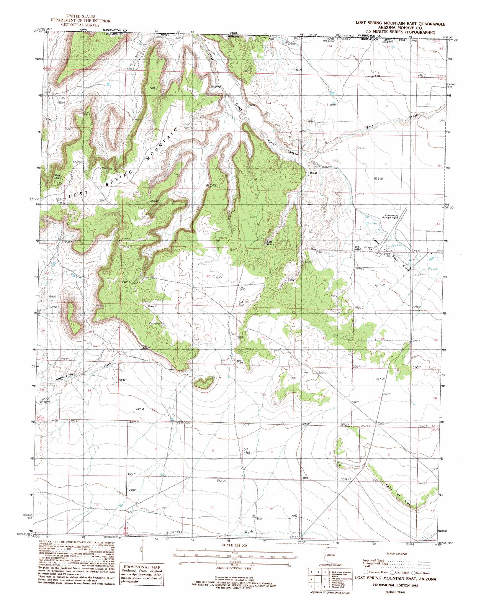
USGS Topo Quad 36113h1 - 1:24,000 scale
| Topo Map Name: | Lost Spring Mountain East |
| USGS Topo Quad ID: | 36113h1 |
| Print Size: | ca. 21 1/4" wide x 27" high |
| Southeast Coordinates: | 36.875° N latitude / 113° W longitude |
| Map Center Coordinates: | 36.9375° N latitude / 113.0625° W longitude |
| U.S. State: | AZ |
| Filename: | o36113h1.jpg |
| Download Map JPG Image: | Lost Spring Mountain East topo map 1:24,000 scale |
| Map Type: | Topographic |
| Topo Series: | 7.5´ |
| Map Scale: | 1:24,000 |
| Source of Map Images: | United States Geological Survey (USGS) |
| Alternate Map Versions: |
Lost Spring NE AZ 1956, updated 1956 Download PDF Buy paper map Lost Spring Mountain East AZ 1988, updated 1988 Download PDF Buy paper map Lost Spring Mountain East AZ 2011 Download PDF Buy paper map Lost Spring Mountain East AZ 2011 Download PDF Buy paper map Lost Spring Mountain East AZ 2014 Download PDF Buy paper map |
1:24,000 Topo Quads surrounding Lost Spring Mountain East
Hurricane |
Virgin |
Springdale West |
Springdale East |
The Barracks |
The Divide |
Little Creek Mountain |
Smithsonian Butte |
Hildale |
Elephant Butte |
Rock Canyon |
Lost Spring Mountain West |
Lost Spring Mountain East |
Colorado City |
Moccasin |
Gyp Pocket |
White Pockets |
Formaster Well |
Maroney Well |
Pipe Valley |
The Grandstand |
Antelope Knoll |
Little Clayhole Valley |
Wild Band Pockets |
Sunshine Ridge |
> Back to 36113e1 at 1:100,000 scale
> Back to 36112a1 at 1:250,000 scale
> Back to U.S. Topo Maps home
Lost Spring Mountain East topo map: Gazetteer
Lost Spring Mountain East: Airports
Colorado City Municipal Airport elevation 1475m 4839′Lost Spring Mountain East: Lakes
Lakes of Short Creek elevation 0m 0′Lost Spring Mountain East: Reservoirs
Road Pond elevation 1495m 4904′Lost Spring Mountain East: Springs
Lost Spring elevation 1528m 5013′Wells Spring elevation 1586m 5203′
Lost Spring Mountain East: Summits
Point Rock elevation 1586m 5203′Lost Spring Mountain East: Valleys
Corral Canyon elevation 1453m 4767′Lost Spring Mountain East digital topo map on disk
Buy this Lost Spring Mountain East topo map showing relief, roads, GPS coordinates and other geographical features, as a high-resolution digital map file on DVD: