Lost Spring Mountain West Topo Map Arizona
To zoom in, hover over the map of Lost Spring Mountain West
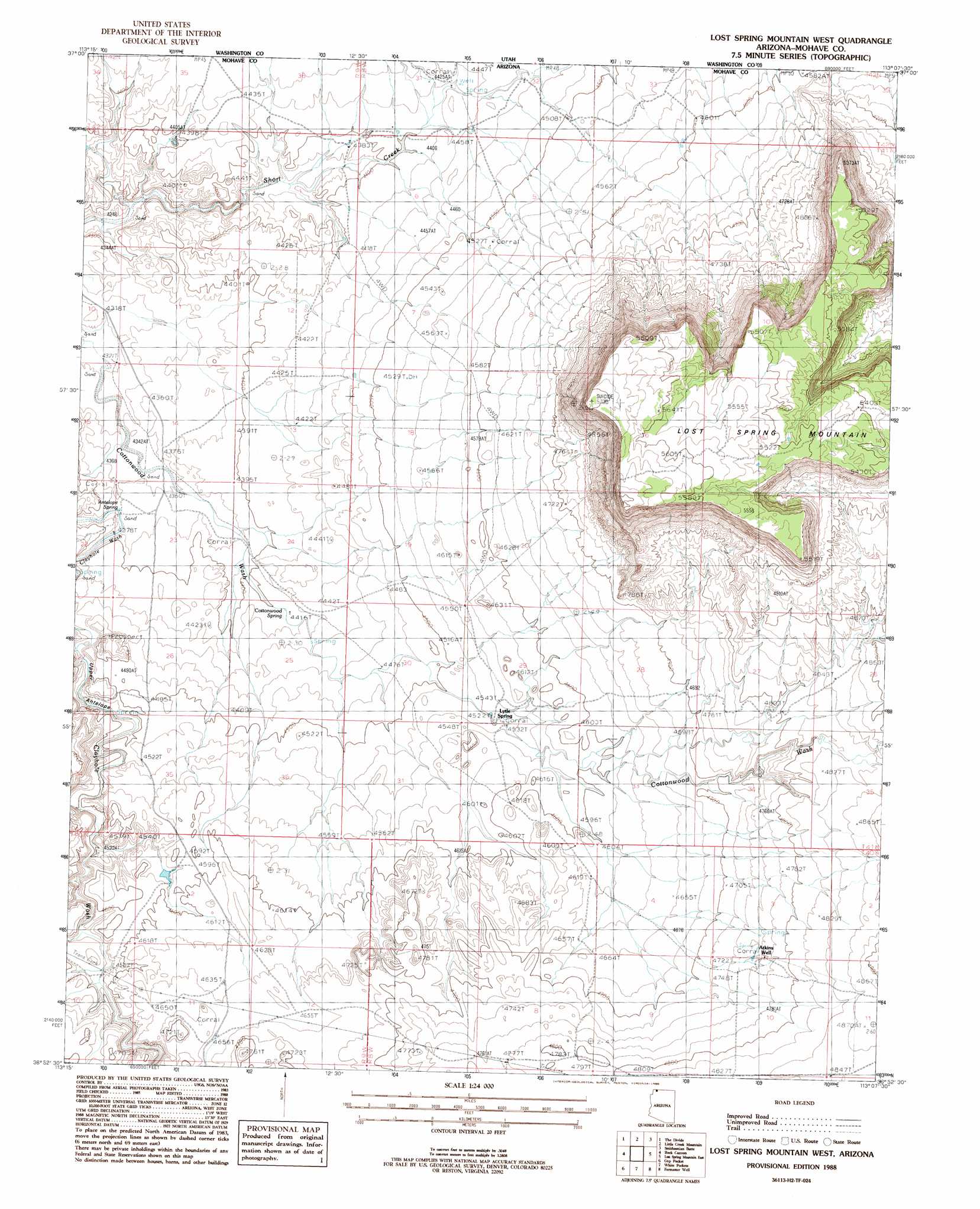
USGS Topo Quad 36113h2 - 1:24,000 scale
| Topo Map Name: | Lost Spring Mountain West |
| USGS Topo Quad ID: | 36113h2 |
| Print Size: | ca. 21 1/4" wide x 27" high |
| Southeast Coordinates: | 36.875° N latitude / 113.125° W longitude |
| Map Center Coordinates: | 36.9375° N latitude / 113.1875° W longitude |
| U.S. State: | AZ |
| Filename: | o36113h2.jpg |
| Download Map JPG Image: | Lost Spring Mountain West topo map 1:24,000 scale |
| Map Type: | Topographic |
| Topo Series: | 7.5´ |
| Map Scale: | 1:24,000 |
| Source of Map Images: | United States Geological Survey (USGS) |
| Alternate Map Versions: |
Lost Spring NW AZ 1954, updated 1956 Download PDF Buy paper map Lost Spring Mountain West AZ 1988, updated 1988 Download PDF Buy paper map Lost Spring Mountain West AZ 2011 Download PDF Buy paper map Lost Spring Mountain West AZ 2011 Download PDF Buy paper map Lost Spring Mountain West AZ 2014 Download PDF Buy paper map |
1:24,000 Topo Quads surrounding Lost Spring Mountain West
Harrisburg Junction |
Hurricane |
Virgin |
Springdale West |
Springdale East |
Washington Dome |
The Divide |
Little Creek Mountain |
Smithsonian Butte |
Hildale |
Yellowhorse Flat |
Rock Canyon |
Lost Spring Mountain West |
Lost Spring Mountain East |
Colorado City |
Hole-N-Wall Canyon |
Gyp Pocket |
White Pockets |
Formaster Well |
Maroney Well |
Dutchman Draw |
The Grandstand |
Antelope Knoll |
Little Clayhole Valley |
Wild Band Pockets |
> Back to 36113e1 at 1:100,000 scale
> Back to 36112a1 at 1:250,000 scale
> Back to U.S. Topo Maps home
Lost Spring Mountain West topo map: Gazetteer
Lost Spring Mountain West: Gaps
Canaan Gap elevation 1420m 4658′Lost Spring Mountain West: Reservoirs
Reeds Reservoir elevation 1377m 4517′Lost Spring Mountain West: Springs
Antelope Spring elevation 1334m 4376′Cottonwood Spring elevation 1345m 4412′
Lytle Spring elevation 1382m 4534′
Upper Lytle Spring elevation 1457m 4780′
Lost Spring Mountain West: Summits
Lost Spring Mountain elevation 1741m 5711′Upper Antelope elevation 1373m 4504′
Lost Spring Mountain West: Wells
Atkins Well elevation 1451m 4760′Lost Spring Mountain West digital topo map on disk
Buy this Lost Spring Mountain West topo map showing relief, roads, GPS coordinates and other geographical features, as a high-resolution digital map file on DVD: