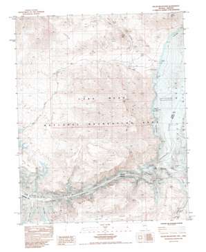
Hiller Mountains Topo Map Nevada
To zoom in, hover over the map of Hiller Mountains
USGS Topo Quad 36114a2 - 1:24,000 scale
| Topo Map Name: | Hiller Mountains |
| USGS Topo Quad ID: | 36114a2 |
| Print Size: | ca. 21 1/4" wide x 27" high |
| Southeast Coordinates: | 36° N latitude / 114.125° W longitude |
| Map Center Coordinates: | 36.0625° N latitude / 114.1875° W longitude |
| U.S. States: | NV, AZ |
| Filename: | o36114a2.jpg |
| Download Map JPG Image: | Hiller Mountains topo map 1:24,000 scale |
| Map Type: | Topographic |
| Topo Series: | 7.5´ |
| Map Scale: | 1:24,000 |
| Source of Map Images: | United States Geological Survey (USGS) |
| Alternate Map Versions: |
Hiller Mountains NV 1983, updated 1984 Download PDF Buy paper map Hiller Mountains NV 2012 Download PDF Buy paper map Hiller Mountains NV 2014 Download PDF Buy paper map |
1:24,000 Topo Quads surrounding Hiller Mountains
> Back to 36114a1 at 1:100,000 scale
> Back to 36114a1 at 1:250,000 scale
> Back to U.S. Topo Maps home
Hiller Mountains topo map: Gazetteer
Hiller Mountains: Bars
Channel Reef elevation 367m 1204′Virgin Reef elevation 367m 1204′
Hiller Mountains: Basins
Black Box elevation 568m 1863′Gregg Basin elevation 367m 1204′
Hiller Mountains: Bays
Burro Bay elevation 367m 1204′Channel Bay elevation 367m 1204′
Gold Cross Bay elevation 367m 1204′
Granite Cove elevation 367m 1204′
Greggs Hideout elevation 367m 1204′
Hualapai Bay elevation 367m 1204′
Little Burro Bay elevation 368m 1207′
Powell Bay elevation 367m 1204′
Reef Bay elevation 367m 1204′
Salt Spring Bay elevation 0m 0′
Scanlon Bay elevation 367m 1204′
Slide Cove elevation 367m 1204′
Spring Cove elevation 367m 1204′
Hiller Mountains: Capes
Rocky Point elevation 384m 1259′Round Rock Point elevation 381m 1250′
Hiller Mountains: Gaps
Jumbo Pass elevation 597m 1958′Hiller Mountains: Islands
Channel Island elevation 367m 1204′Haulapai Island elevation 367m 1204′
Hualapai Island elevation 367m 1204′
Hiller Mountains: Mines
Eureka Mine elevation 458m 1502′Joker Mine elevation 482m 1581′
Jumbo Mine elevation 566m 1856′
Union Mine elevation 720m 2362′
Hiller Mountains: Ranges
Hiller Mountains elevation 659m 2162′Hiller Mountains: Rapids
Hualpai Rapids (historical) elevation 367m 1204′Hiller Mountains: Springs
Burro Spring elevation 437m 1433′Hiller Mountains: Streams
Gregg Wash elevation 380m 1246′Hualapai Wash elevation 391m 1282′
Scanlon Wash elevation 394m 1292′
Wild Burro Wash elevation 367m 1204′
Hiller Mountains: Summits
Gold Cross Peak elevation 1030m 3379′Gregg Peak elevation 754m 2473′
Powell Mountain elevation 777m 2549′
Scanlon Hill elevation 428m 1404′
Temple Mesa elevation 486m 1594′
Hiller Mountains: Valleys
Spring Canyon elevation 397m 1302′Hiller Mountains digital topo map on disk
Buy this Hiller Mountains topo map showing relief, roads, GPS coordinates and other geographical features, as a high-resolution digital map file on DVD:
Southern Sierra Nevada, California & Southern Nevada
Buy digital topo maps: Southern Sierra Nevada, California & Southern Nevada


