Iceberg Canyon Topo Map Arizona
To zoom in, hover over the map of Iceberg Canyon
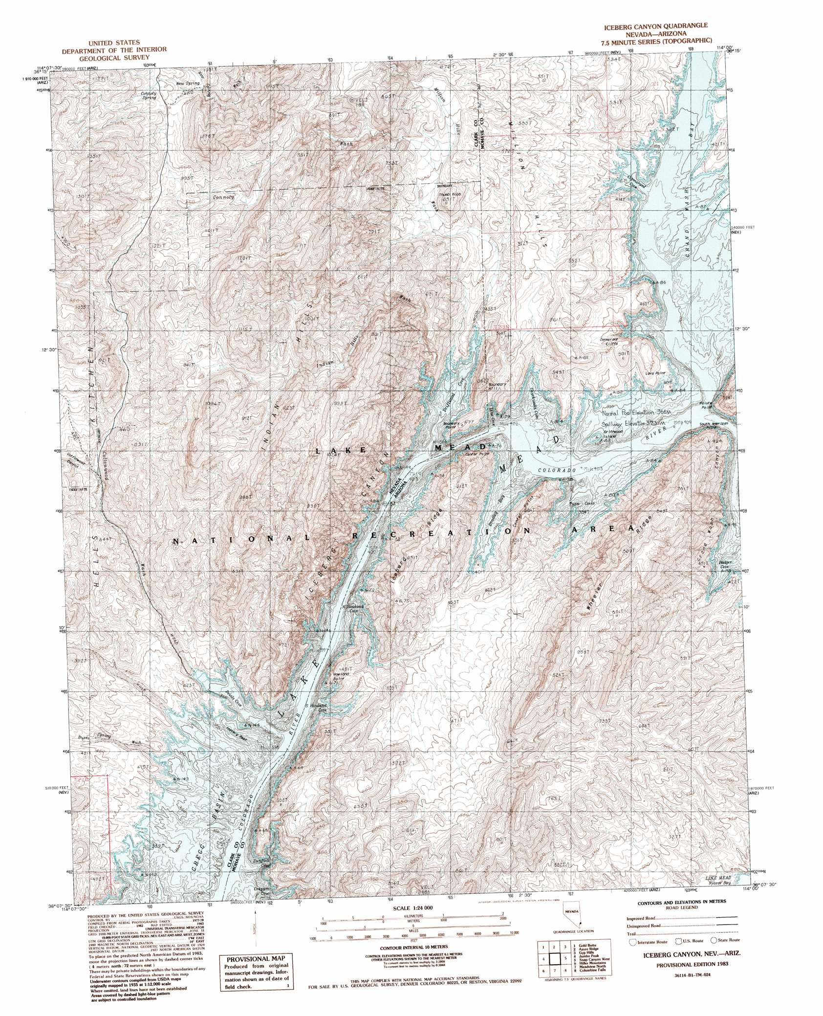
USGS Topo Quad 36114b1 - 1:24,000 scale
| Topo Map Name: | Iceberg Canyon |
| USGS Topo Quad ID: | 36114b1 |
| Print Size: | ca. 21 1/4" wide x 27" high |
| Southeast Coordinates: | 36.125° N latitude / 114° W longitude |
| Map Center Coordinates: | 36.1875° N latitude / 114.0625° W longitude |
| U.S. States: | AZ, NV |
| Filename: | o36114b1.jpg |
| Download Map JPG Image: | Iceberg Canyon topo map 1:24,000 scale |
| Map Type: | Topographic |
| Topo Series: | 7.5´ |
| Map Scale: | 1:24,000 |
| Source of Map Images: | United States Geological Survey (USGS) |
| Alternate Map Versions: |
Iceberg Canyon NV 1983, updated 1984 Download PDF Buy paper map Iceberg Canyon NV 2012 Download PDF Buy paper map Iceberg Canyon NV 2014 Download PDF Buy paper map |
1:24,000 Topo Quads surrounding Iceberg Canyon
Overton Beach |
Devils Throat |
Saint Thomas Gap |
Pakoon Springs |
Olaf Knolls |
Lime Wash |
Gold Butte |
Azure Ridge |
Gyp Hills |
Grand Gulch Bench |
Garrett Butte |
Jumbo Peak |
Iceberg Canyon |
Snap Canyon West |
Snap Canyon East |
The Temple |
Hiller Mountains |
Meadview North |
Columbine Falls |
Bat Cave |
Senator Mountain Ne |
Garnet Mountain Nw |
Meadview South |
Grapevine Canyon |
Quartermaster Canyon |
> Back to 36114a1 at 1:100,000 scale
> Back to 36114a1 at 1:250,000 scale
> Back to U.S. Topo Maps home
Iceberg Canyon topo map: Gazetteer
Iceberg Canyon: Bars
Iceberg Reef elevation 367m 1204′Iceberg Canyon: Bays
Badger Cove elevation 367m 1204′Bradley Bay elevation 367m 1204′
Chuckwalla Cove elevation 367m 1204′
Cormorant Cove elevation 367m 1204′
Crappie Cove elevation 368m 1207′
Devils Cove elevation 367m 1204′
Driftwood Cove elevation 367m 1204′
Grand Wash Bay elevation 367m 1204′
Line Cove elevation 367m 1204′
North Howland Cove elevation 376m 1233′
South Howland Cove elevation 367m 1204′
Sunfish Cove elevation 367m 1204′
Twin Coves elevation 367m 1204′
Iceberg Canyon: Capes
Boundary Point elevation 455m 1492′Howland Point elevation 414m 1358′
Lava Point elevation 391m 1282′
Paiute Point elevation 430m 1410′
South American Point elevation 771m 2529′
Iceberg Canyon: Cliffs
Center Point elevation 521m 1709′Cormorant Cliffs elevation 371m 1217′
Iceberg Canyon: Islands
Driftwood Island elevation 372m 1220′Iceberg Canyon: Ranges
Indian Hills elevation 959m 3146′Iceberg Canyon: Ridges
Iceberg Ridge elevation 565m 1853′Wheeler Ridge elevation 820m 2690′
Iceberg Canyon: Springs
Connoly Spring elevation 1053m 3454′New Spring elevation 1020m 3346′
Iceberg Canyon: Streams
Burro Spring Wash elevation 374m 1227′Connoly Wash elevation 556m 1824′
Cottonwood Wash elevation 377m 1236′
Indian Hills Wash elevation 377m 1236′
Million Hills Wash elevation 377m 1236′
New Spring Wash elevation 905m 2969′
Iceberg Canyon: Summits
Boundary Hill elevation 528m 1732′Boundary Hill elevation 557m 1827′
Million Hills elevation 623m 2043′
Thumb Knob elevation 634m 2080′
Iceberg Canyon: Valleys
Cottonwood Canyon elevation 369m 1210′Grand Wash Canyon elevation 367m 1204′
Iceberg Canyon elevation 367m 1204′
Iceberg Canyon elevation 367m 1204′
Pigeon Wash elevation 367m 1204′
Iceberg Canyon digital topo map on disk
Buy this Iceberg Canyon topo map showing relief, roads, GPS coordinates and other geographical features, as a high-resolution digital map file on DVD:
Southern Sierra Nevada, California & Southern Nevada
Buy digital topo maps: Southern Sierra Nevada, California & Southern Nevada