Las Vegas Se Topo Map Nevada
To zoom in, hover over the map of Las Vegas Se
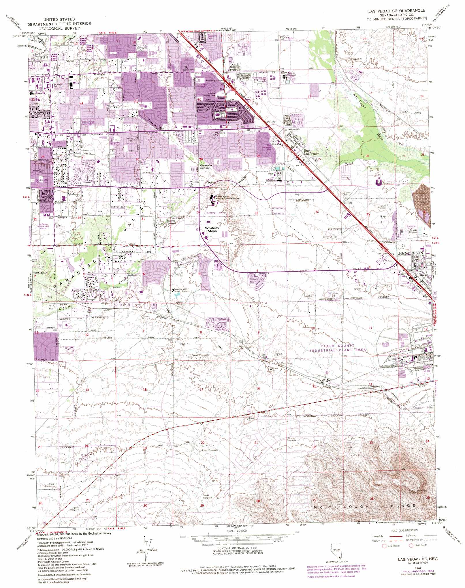
USGS Topo Quad 36115a1 - 1:24,000 scale
| Topo Map Name: | Las Vegas Se |
| USGS Topo Quad ID: | 36115a1 |
| Print Size: | ca. 21 1/4" wide x 27" high |
| Southeast Coordinates: | 36° N latitude / 115° W longitude |
| Map Center Coordinates: | 36.0625° N latitude / 115.0625° W longitude |
| U.S. State: | NV |
| Filename: | o36115a1.jpg |
| Download Map JPG Image: | Las Vegas Se topo map 1:24,000 scale |
| Map Type: | Topographic |
| Topo Series: | 7.5´ |
| Map Scale: | 1:24,000 |
| Source of Map Images: | United States Geological Survey (USGS) |
| Alternate Map Versions: |
Las Vegas SE NV 1967, updated 1968 Download PDF Buy paper map Las Vegas SE NV 1967, updated 1976 Download PDF Buy paper map Las Vegas SE NV 1967, updated 1984 Download PDF Buy paper map Las Vegas SE NV 1967, updated 1984 Download PDF Buy paper map Las Vegas SE NV 1967, updated 1984 Download PDF Buy paper map Las Vegas SE NV 1973, updated 1977 Download PDF Buy paper map Las Vegas SE NV 2012 Download PDF Buy paper map Las Vegas SE NV 2015 Download PDF Buy paper map |
1:24,000 Topo Quads surrounding Las Vegas Se
Tule Springs Park |
Gass Peak Sw |
Valley |
Apex |
Dry Lake Se |
Blue Diamond Ne |
Las Vegas Nw |
Las Vegas Ne |
Frenchman Mountain |
Government Wash |
Blue Diamond Se |
Las Vegas Sw |
Las Vegas Se |
Henderson |
Boulder Beach |
Bird Spring |
Sloan |
Sloan Ne |
Boulder City Nw |
Boulder City |
Jean |
Hidden Valley |
Sloan Se |
Boulder City Sw |
Boulder City Se |
> Back to 36115a1 at 1:100,000 scale
> Back to 36114a1 at 1:250,000 scale
> Back to U.S. Topo Maps home
Las Vegas Se topo map: Gazetteer
Las Vegas Se: Airports
Voc Tech Airport elevation 582m 1909′Whitney Airport (historical) elevation 507m 1663′
Las Vegas Se: Parks
Arroyo Grande Sports Complex elevation 563m 1847′Cannon School Park elevation 611m 2004′
Desert Inn Park elevation 526m 1725′
Desert Inn Pool elevation 525m 1722′
Discovery Park elevation 665m 2181′
Downs Linear Park elevation 636m 2086′
East Las Vegas Park elevation 510m 1673′
Ferron Park elevation 528m 1732′
Fox Ridge Park elevation 579m 1899′
Grapevine Springs Park elevation 550m 1804′
Green Valley Park elevation 617m 2024′
Horsemans and Dog Fanciers Park elevation 512m 1679′
Legacy West Park elevation 623m 2043′
Maslow County Park elevation 525m 1722′
Maslow Pool elevation 524m 1719′
Mountain View Park elevation 628m 2060′
Paradise Park elevation 598m 1961′
Paradise Pool elevation 599m 1965′
Paradise Valley County Park elevation 598m 1961′
Rodeo Park elevation 498m 1633′
Silver Bowl Park elevation 481m 1578′
Silver Springs Park elevation 598m 1961′
Silver Springs Pool elevation 599m 1965′
Sunset Park elevation 613m 2011′
Sunset Pool elevation 617m 2024′
Wells Park elevation 505m 1656′
Wells Pool elevation 505m 1656′
White School Park and Sports Field elevation 550m 1804′
Whitney Park elevation 509m 1669′
Whitney Pool elevation 510m 1673′
Las Vegas Se: Populated Places
East Las Vegas elevation 505m 1656′Whitney elevation 593m 1945′
Las Vegas Se: Post Offices
East Las Vegas Branch Post Office elevation 507m 1663′Green Valley Post Office elevation 594m 1948′
Pittman Station Post Office elevation 508m 1666′
Poe 62 Post Office elevation 605m 1984′
Poe 67 Post Office elevation 623m 2043′
Valle Verde Post Office elevation 655m 2148′
Las Vegas Se: Springs
Cow Spring elevation 538m 1765′Grapvine Springs elevation 547m 1794′
Mesquite Spring elevation 592m 1942′
Stevens Springs elevation 580m 1902′
Las Vegas Se: Streams
Duck Creek elevation 480m 1574′Las Vegas Se: Summits
Whitney Mesa elevation 584m 1916′Las Vegas Se: Valleys
Paradise Valley elevation 572m 1876′Las Vegas Se: Wells
Mesquite Well (historical) elevation 543m 1781′Whitney Well elevation 524m 1719′
Las Vegas Se digital topo map on disk
Buy this Las Vegas Se topo map showing relief, roads, GPS coordinates and other geographical features, as a high-resolution digital map file on DVD:
Southern Sierra Nevada, California & Southern Nevada
Buy digital topo maps: Southern Sierra Nevada, California & Southern Nevada