Blue Diamond Ne Topo Map Nevada
To zoom in, hover over the map of Blue Diamond Ne
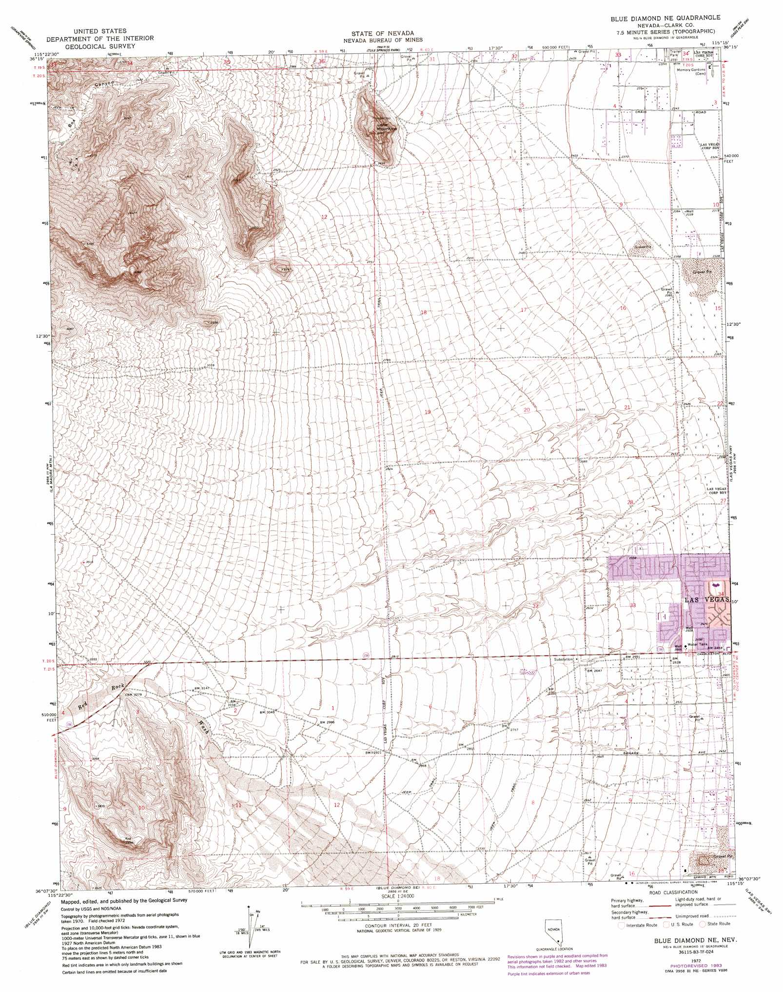
USGS Topo Quad 36115b3 - 1:24,000 scale
| Topo Map Name: | Blue Diamond Ne |
| USGS Topo Quad ID: | 36115b3 |
| Print Size: | ca. 21 1/4" wide x 27" high |
| Southeast Coordinates: | 36.125° N latitude / 115.25° W longitude |
| Map Center Coordinates: | 36.1875° N latitude / 115.3125° W longitude |
| U.S. State: | NV |
| Filename: | o36115b3.jpg |
| Download Map JPG Image: | Blue Diamond Ne topo map 1:24,000 scale |
| Map Type: | Topographic |
| Topo Series: | 7.5´ |
| Map Scale: | 1:24,000 |
| Source of Map Images: | United States Geological Survey (USGS) |
| Alternate Map Versions: |
Blue Diamond NE NV 1972, updated 1974 Download PDF Buy paper map Blue Diamond NE NV 1972, updated 1984 Download PDF Buy paper map Blue Diamond NE NV 2012 Download PDF Buy paper map Blue Diamond NE NV 2015 Download PDF Buy paper map |
1:24,000 Topo Quads surrounding Blue Diamond Ne
Charleston Peak Ne |
Corn Creek Springs Nw |
Corn Creek Springs |
Gass Peak |
Gass Peak Ne |
Angel Peak |
Grapevine Spring |
Tule Springs Park |
Gass Peak Sw |
Valley |
La Madre Spring |
La Madre Mountain |
Blue Diamond Ne |
Las Vegas Nw |
Las Vegas Ne |
Mountain Springs |
Blue Diamond |
Blue Diamond Se |
Las Vegas Sw |
Las Vegas Se |
Potosi |
Cottonwood Pass |
Bird Spring |
Sloan |
Sloan Ne |
> Back to 36115a1 at 1:100,000 scale
> Back to 36114a1 at 1:250,000 scale
> Back to U.S. Topo Maps home
Blue Diamond Ne topo map: Gazetteer
Blue Diamond Ne: Mines
Iron Age Mine elevation 1236m 4055′Blue Diamond Ne: Parks
Aloha Shores Park elevation 719m 2358′Angel Park elevation 803m 2634′
Ansan Park elevation 773m 2536′
Hills Park elevation 796m 2611′
Johnson Community School Park elevation 770m 2526′
Lone Mountain Park elevation 845m 2772′
Pueblo Park elevation 750m 2460′
Smith Playground elevation 750m 2460′
Trails Park elevation 859m 2818′
Trails Pool elevation 829m 2719′
Trent Park elevation 804m 2637′
W Wayne Bunker Family Park elevation 710m 2329′
Blue Diamond Ne: Post Offices
Poe 64 Post Office elevation 744m 2440′Red Rock Vista Post Office elevation 720m 2362′
Summerlin Post Office elevation 839m 2752′
Blue Diamond Ne: Springs
Whitehead Springs elevation 767m 2516′Blue Diamond Ne: Streams
Red Rock Wash elevation 931m 3054′Blue Diamond Ne: Summits
Lone Mountain elevation 971m 3185′Blue Diamond Ne: Valleys
Box Canyon elevation 1037m 3402′Blue Diamond Ne digital topo map on disk
Buy this Blue Diamond Ne topo map showing relief, roads, GPS coordinates and other geographical features, as a high-resolution digital map file on DVD:
Southern Sierra Nevada, California & Southern Nevada
Buy digital topo maps: Southern Sierra Nevada, California & Southern Nevada