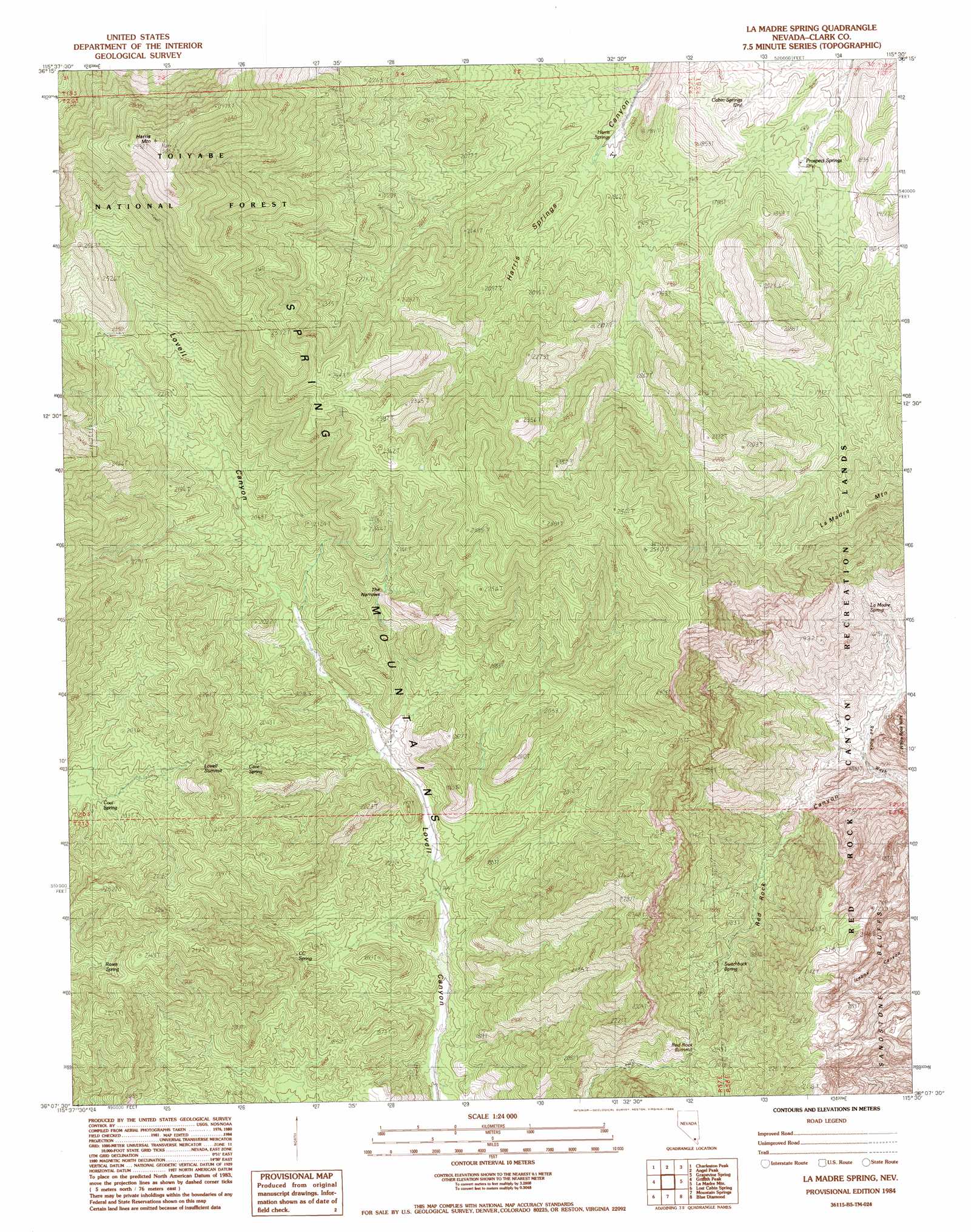
La Madre Spring Topo Map Nevada
To zoom in, hover over the map of La Madre Spring
USGS Topo Quad 36115b5 - 1:24,000 scale
| Topo Map Name: | La Madre Spring |
| USGS Topo Quad ID: | 36115b5 |
| Print Size: | ca. 21 1/4" wide x 27" high |
| Southeast Coordinates: | 36.125° N latitude / 115.5° W longitude |
| Map Center Coordinates: | 36.1875° N latitude / 115.5625° W longitude |
| U.S. State: | NV |
| Filename: | o36115b5.jpg |
| Download Map JPG Image: | La Madre Spring topo map 1:24,000 scale |
| Map Type: | Topographic |
| Topo Series: | 7.5´ |
| Map Scale: | 1:24,000 |
| Source of Map Images: | United States Geological Survey (USGS) |
| Alternate Map Versions: |
La Madre Spring NV 1984, updated 1984 Download PDF Buy paper map La Madre Spring NV 1984, updated 1984 Download PDF Buy paper map La Madre Spring NV 2012 Download PDF Buy paper map La Madre Spring NV 2014 Download PDF Buy paper map |
| FStopo: | US Forest Service topo La Madre Spring is available: Download FStopo PDF Download FStopo TIF |
1:24,000 Topo Quads surrounding La Madre Spring
Willow Peak |
Cold Creek |
Charleston Peak Ne |
Corn Creek Springs Nw |
Corn Creek Springs |
Wheeler Well |
Charleston Peak |
Angel Peak |
Grapevine Spring |
Tule Springs Park |
Pahrump Ne |
Griffith Peak |
La Madre Spring |
La Madre Mountain |
Blue Diamond Ne |
Hidden Hills Ranch |
Lost Cabin Spring |
Mountain Springs |
Blue Diamond |
Blue Diamond Se |
Stump Spring |
Green Monster Mine |
Potosi |
Cottonwood Pass |
Bird Spring |
> Back to 36115a1 at 1:100,000 scale
> Back to 36114a1 at 1:250,000 scale
> Back to U.S. Topo Maps home
La Madre Spring topo map: Gazetteer
La Madre Spring: Cliffs
Sandstone Bluffs elevation 1950m 6397′La Madre Spring: Gaps
Lovell Summit elevation 2058m 6751′Red Rock Summit elevation 2289m 7509′
The Narrows elevation 2041m 6696′
La Madre Spring: Parks
Pine Creek Canyon Natural Area elevation 1662m 5452′La Madre Spring: Ridges
Wilson Ridge elevation 2513m 8244′La Madre Spring: Springs
Big Timber Spring elevation 1952m 6404′Bootlegger Spring elevation 1998m 6555′
Cabin Springs elevation 1689m 5541′
Cane Spring elevation 1801m 5908′
Cave Spring elevation 1941m 6368′
Caybank Spring elevation 1941m 6368′
CC Spring elevation 1876m 6154′
Center Springs elevation 2031m 6663′
Coal Spring elevation 1960m 6430′
Gallon Tank Spring elevation 1959m 6427′
Harris Springs elevation 1780m 5839′
La Madre Spring elevation 1650m 5413′
Prospect Springs elevation 1695m 5561′
Roses Spring elevation 2003m 6571′
Sheep Spring elevation 1920m 6299′
South Fork Spring elevation 2087m 6847′
Switchback Spring elevation 1781m 5843′
White Point Spring elevation 2092m 6863′
La Madre Spring: Summits
Harris Mountain elevation 3052m 10013′La Madre Spring: Trails
Griffith Peak Trail elevation 2810m 9219′La Madre Spring: Valleys
Lost Creek Canyon elevation 1404m 4606′Red Rock Canyon elevation 1438m 4717′
Willow Canyon elevation 1800m 5905′
La Madre Spring digital topo map on disk
Buy this La Madre Spring topo map showing relief, roads, GPS coordinates and other geographical features, as a high-resolution digital map file on DVD:
Southern Sierra Nevada, California & Southern Nevada
Buy digital topo maps: Southern Sierra Nevada, California & Southern Nevada