Black Hills Topo Map Nevada
To zoom in, hover over the map of Black Hills
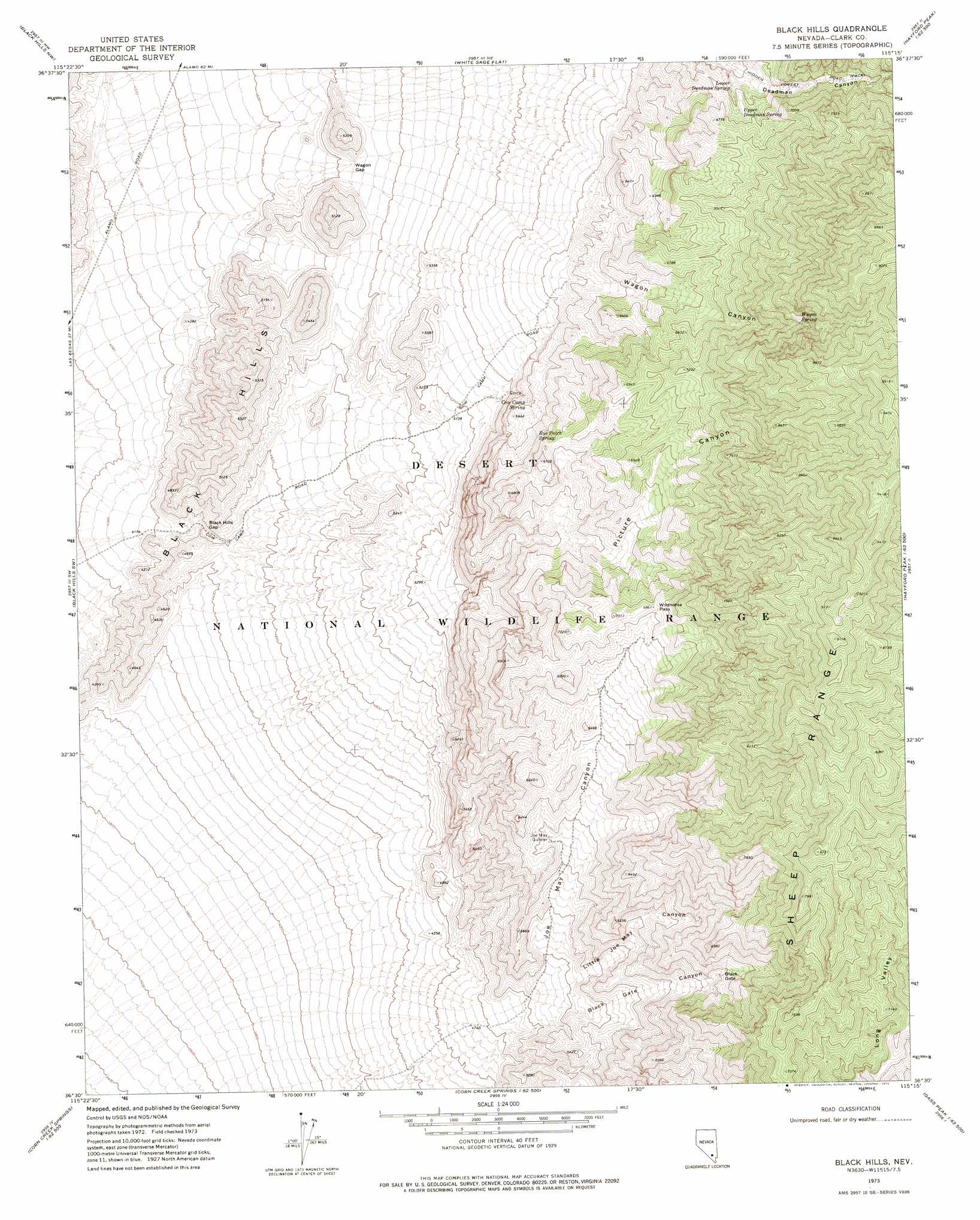
USGS Topo Quad 36115e3 - 1:24,000 scale
| Topo Map Name: | Black Hills |
| USGS Topo Quad ID: | 36115e3 |
| Print Size: | ca. 21 1/4" wide x 27" high |
| Southeast Coordinates: | 36.5° N latitude / 115.25° W longitude |
| Map Center Coordinates: | 36.5625° N latitude / 115.3125° W longitude |
| U.S. State: | NV |
| Filename: | o36115e3.jpg |
| Download Map JPG Image: | Black Hills topo map 1:24,000 scale |
| Map Type: | Topographic |
| Topo Series: | 7.5´ |
| Map Scale: | 1:24,000 |
| Source of Map Images: | United States Geological Survey (USGS) |
| Alternate Map Versions: |
Black Hills NV 1973, updated 1976 Download PDF Buy paper map |
1:24,000 Topo Quads surrounding Black Hills
Tim Spring |
Dog Bone Lake South |
Dead Horse Ridge |
Mule Deer Ridge |
Mule Deer Ridge Se |
Heavens Well |
Black Hills Nw |
White Sage Flat |
Hayford Peak |
Mormon Well |
Indian Springs Se |
Black Hills Sw |
Black Hills |
Sheep Peak |
Hayford Peak Se |
Charleston Peak Ne |
Corn Creek Springs Nw |
Corn Creek Springs |
Gass Peak |
Gass Peak Ne |
Angel Peak |
Grapevine Spring |
Tule Springs Park |
Gass Peak Sw |
Valley |
> Back to 36115e1 at 1:100,000 scale
> Back to 36114a1 at 1:250,000 scale
> Back to U.S. Topo Maps home
Black Hills topo map: Gazetteer
Black Hills: Gaps
Black Gate elevation 1897m 6223′Black Hills Gap elevation 1328m 4356′
Wagon Gap elevation 1472m 4829′
Wildhorse Pass elevation 2092m 6863′
Black Hills: Ranges
Black Hills elevation 1479m 4852′Black Hills: Reservoirs
Joe May Guzzler elevation 1750m 5741′Black Hills: Springs
Cow Camp Spring elevation 1756m 5761′Lower Deadman Spring elevation 1941m 6368′
Rye Patch Spring elevation 1898m 6227′
Upper Deadman Spring elevation 1989m 6525′
Wagon Spring elevation 2341m 7680′
Black Hills: Valleys
Black Gate Canyon elevation 1581m 5187′Joe May Canyon elevation 1429m 4688′
Little Joe May Canyon elevation 1535m 5036′
Picture Canyon elevation 1646m 5400′
Wagon Canyon elevation 1793m 5882′
Black Hills digital topo map on disk
Buy this Black Hills topo map showing relief, roads, GPS coordinates and other geographical features, as a high-resolution digital map file on DVD:
Southern Sierra Nevada, California & Southern Nevada
Buy digital topo maps: Southern Sierra Nevada, California & Southern Nevada