Mount Schader Topo Map Nevada
To zoom in, hover over the map of Mount Schader
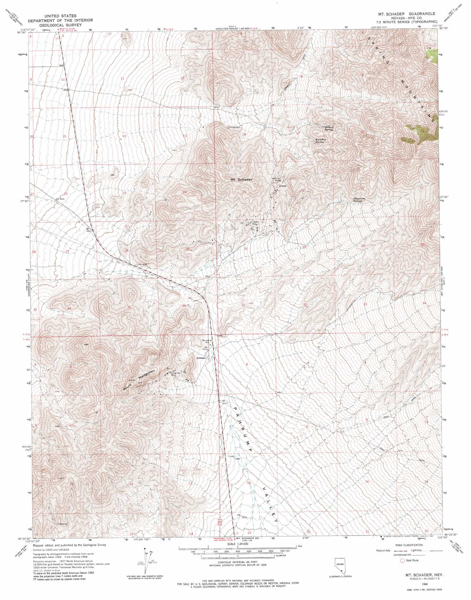
USGS Topo Quad 36116d1 - 1:24,000 scale
| Topo Map Name: | Mount Schader |
| USGS Topo Quad ID: | 36116d1 |
| Print Size: | ca. 21 1/4" wide x 27" high |
| Southeast Coordinates: | 36.375° N latitude / 116° W longitude |
| Map Center Coordinates: | 36.4375° N latitude / 116.0625° W longitude |
| U.S. State: | NV |
| Filename: | o36116d1.jpg |
| Download Map JPG Image: | Mount Schader topo map 1:24,000 scale |
| Map Type: | Topographic |
| Topo Series: | 7.5´ |
| Map Scale: | 1:24,000 |
| Source of Map Images: | United States Geological Survey (USGS) |
| Alternate Map Versions: |
Mt. Schader NV 1968, updated 1972 Download PDF Buy paper map Mt. Schader NV 1968, updated 1980 Download PDF Buy paper map Mount Schader NV 2012 Download PDF Buy paper map Mount Schader NV 2014 Download PDF Buy paper map |
| FStopo: | US Forest Service topo Mount Schader is available: Download FStopo PDF Download FStopo TIF |
1:24,000 Topo Quads surrounding Mount Schader
Striped Hills |
Specter Range Nw |
Camp Desert Rock |
Mercury |
Mercury Ne |
Skeleton Hills |
Specter Range Sw |
Point Of Rocks |
Niavi Wash |
Mercury Se |
Devils Hole |
Amargosa Flat |
Mount Schader |
Mount Stirling |
Willow Peak |
Bole Spring |
High Peak |
Last Chance Range |
Horse Springs |
Wheeler Well |
Eagle Mountain |
Stewart Valley |
Sixmile Spring |
Pahrump |
Pahrump Ne |
> Back to 36116a1 at 1:100,000 scale
> Back to 36116a1 at 1:250,000 scale
> Back to U.S. Topo Maps home
Mount Schader topo map: Gazetteer
Mount Schader: Flats
Mineral Flat elevation 1004m 3293′Mount Schader: Mines
Black Jack Mine elevation 1079m 3540′Congress Mine elevation 1096m 3595′
Fred Bowlers Mine elevation 1140m 3740′
Johnnie Mine elevation 1236m 4055′
Labbe Mine elevation 1142m 3746′
Overfield Mine elevation 1234m 4048′
Mount Schader: Populated Places
Bowlerville (historical) elevation 1147m 3763′Johnnie elevation 1010m 3313′
Labbe Camp elevation 1119m 3671′
Mount Schader: Post Offices
Johnnie Mine Post Office elevation 1239m 4064′Johnnie Post Office elevation 1010m 3313′
Mount Schader: Ranges
Johnnie Range elevation 1133m 3717′Mount Schader: Springs
Diebert Spring elevation 1241m 4071′Grapevine Springs elevation 1359m 4458′
Kwichup Spring elevation 1212m 3976′
Mount Schader: Summits
Mount Montgomery elevation 1301m 4268′Mount Schader elevation 1309m 4294′
Mount Schader digital topo map on disk
Buy this Mount Schader topo map showing relief, roads, GPS coordinates and other geographical features, as a high-resolution digital map file on DVD:
Southern Sierra Nevada, California & Southern Nevada
Buy digital topo maps: Southern Sierra Nevada, California & Southern Nevada