Lathrop Wells Topo Map Nevada
To zoom in, hover over the map of Lathrop Wells
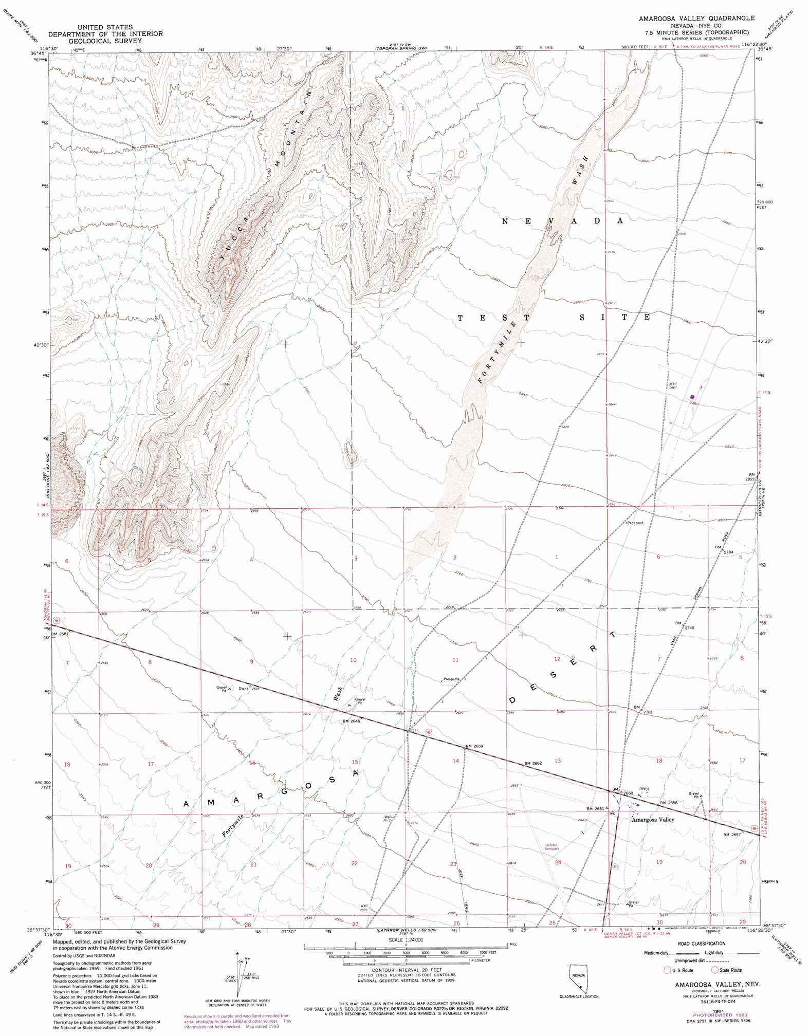
USGS Topo Quad 36116f4 - 1:24,000 scale
| Topo Map Name: | Lathrop Wells |
| USGS Topo Quad ID: | 36116f4 |
| Print Size: | ca. 21 1/4" wide x 27" high |
| Southeast Coordinates: | 36.625° N latitude / 116.375° W longitude |
| Map Center Coordinates: | 36.6875° N latitude / 116.4375° W longitude |
| U.S. State: | NV |
| Filename: | o36116f4.jpg |
| Download Map JPG Image: | Lathrop Wells topo map 1:24,000 scale |
| Map Type: | Topographic |
| Topo Series: | 7.5´ |
| Map Scale: | 1:24,000 |
| Source of Map Images: | United States Geological Survey (USGS) |
| Alternate Map Versions: |
Lathrop Wells NV 1961, updated 1962 Download PDF Buy paper map Lathrop Wells NV 1961, updated 1975 Download PDF Buy paper map Amargosa Valley NV 1961, updated 1984 Download PDF Buy paper map |
1:24,000 Topo Quads surrounding Lathrop Wells
Beatty Mountain |
East Of Beatty Mountain |
Topopah Springs Nw |
Topopah Spring |
Mine Mountain |
Carrara Canyon |
Crater Flat |
Busted Butte |
Jackass Flats |
Skull Mountain |
Ashton |
Big Dune |
Lathrop Wells |
Striped Hills |
Specter Range Nw |
Lees Camp |
Leeland |
South Of Amargosa Valley |
Skeleton Hills |
Specter Range Sw |
Echo Canyon |
East Of Echo Canyon |
Franklin Well |
Devils Hole |
Amargosa Flat |
> Back to 36116e1 at 1:100,000 scale
> Back to 36116a1 at 1:250,000 scale
> Back to U.S. Topo Maps home
Lathrop Wells topo map: Gazetteer
Lathrop Wells: Airports
Jackass Aeropark elevation 799m 2621′Lathrop Wells: Populated Places
Amargosa Valley elevation 812m 2664′Lathrop Wells: Post Offices
Amargosa Valley Post Office elevation 812m 2664′Lathrop Wells: Ridges
Azrael Ridge elevation 812m 2664′Black Ridge elevation 851m 2791′
Desolation Point elevation 944m 3097′
Lathrop Wells: Streams
Topopah Wash elevation 842m 2762′Lathrop Wells digital topo map on disk
Buy this Lathrop Wells topo map showing relief, roads, GPS coordinates and other geographical features, as a high-resolution digital map file on DVD:
Southern Sierra Nevada, California & Southern Nevada
Buy digital topo maps: Southern Sierra Nevada, California & Southern Nevada