Topopah Springs Nw Topo Map Nevada
To zoom in, hover over the map of Topopah Springs Nw
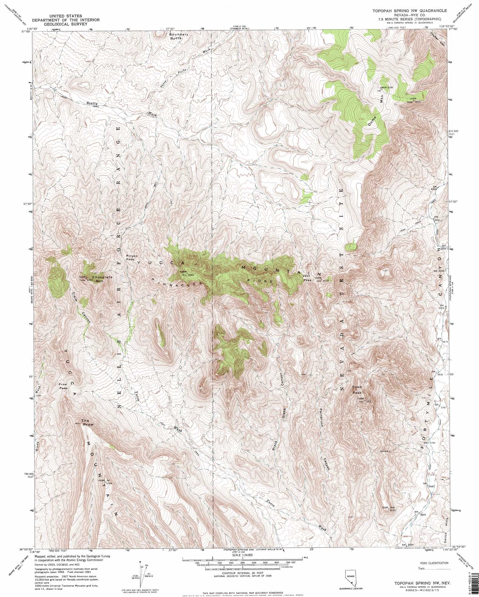
USGS Topo Quad 36116h4 - 1:24,000 scale
| Topo Map Name: | Topopah Springs Nw |
| USGS Topo Quad ID: | 36116h4 |
| Print Size: | ca. 21 1/4" wide x 27" high |
| Southeast Coordinates: | 36.875° N latitude / 116.375° W longitude |
| Map Center Coordinates: | 36.9375° N latitude / 116.4375° W longitude |
| U.S. State: | NV |
| Filename: | o36116h4.jpg |
| Download Map JPG Image: | Topopah Springs Nw topo map 1:24,000 scale |
| Map Type: | Topographic |
| Topo Series: | 7.5´ |
| Map Scale: | 1:24,000 |
| Source of Map Images: | United States Geological Survey (USGS) |
| Alternate Map Versions: |
Topopah Spring NW NV 1961, updated 1962 Download PDF Buy paper map Topopah Spring NW NV 1961, updated 1975 Download PDF Buy paper map Topopah Spring NW NV 1961, updated 1975 Download PDF Buy paper map |
1:24,000 Topo Quads surrounding Topopah Springs Nw
Thirsty Canyon Nw |
Thirsty Canyon |
Scrugham Peak |
Ammonia Tanks |
Rainier Mesa |
Thirsty Canyon Sw |
Thirsty Canyon Se |
Timber Mountain |
Buckboard Mesa |
Tippipah Spring |
Beatty Mountain |
East Of Beatty Mountain |
Topopah Springs Nw |
Topopah Spring |
Mine Mountain |
Carrara Canyon |
Crater Flat |
Busted Butte |
Jackass Flats |
Skull Mountain |
Ashton |
Big Dune |
Lathrop Wells |
Striped Hills |
Specter Range Nw |
> Back to 36116e1 at 1:100,000 scale
> Back to 36116a1 at 1:250,000 scale
> Back to U.S. Topo Maps home
Topopah Springs Nw topo map: Gazetteer
Topopah Springs Nw: Capes
Castle Point elevation 1574m 5164′Topopah Springs Nw: Gaps
Pinyon Pass elevation 1759m 5770′Prow Pass elevation 1594m 5229′
Vent Pass elevation 1735m 5692′
Topopah Springs Nw: Ranges
Yucca Mountain elevation 1999m 6558′Topopah Springs Nw: Ridges
Castellated Ridge elevation 1779m 5836′Isolation Ridge elevation 1376m 4514′
Isolation Ridge elevation 1376m 4514′
Jake Ridge elevation 1605m 5265′
Jet Ridge elevation 1785m 5856′
Joey Ridge elevation 1605m 5265′
Pinnacles Ridge elevation 1879m 6164′
West Ridge elevation 1779m 5836′
Topopah Springs Nw: Streams
Three Forks Wash elevation 1463m 4799′Topopah Springs Nw: Summits
Boundary Butte elevation 1636m 5367′Chocolate Mountain elevation 2017m 6617′
Comb Peak elevation 1630m 5347′
Dome Mountain elevation 1891m 6204′
The Prow elevation 1782m 5846′
Topopah Springs Nw: Valleys
Black Glass Canyon elevation 1189m 3900′Claim Canyon elevation 1439m 4721′
Delirium Canyon elevation 1184m 3884′
Pah Canyon elevation 1209m 3966′
Paintbrush Canyon elevation 1169m 3835′
Topopah Springs Nw digital topo map on disk
Buy this Topopah Springs Nw topo map showing relief, roads, GPS coordinates and other geographical features, as a high-resolution digital map file on DVD:
Southern Sierra Nevada, California & Southern Nevada
Buy digital topo maps: Southern Sierra Nevada, California & Southern Nevada