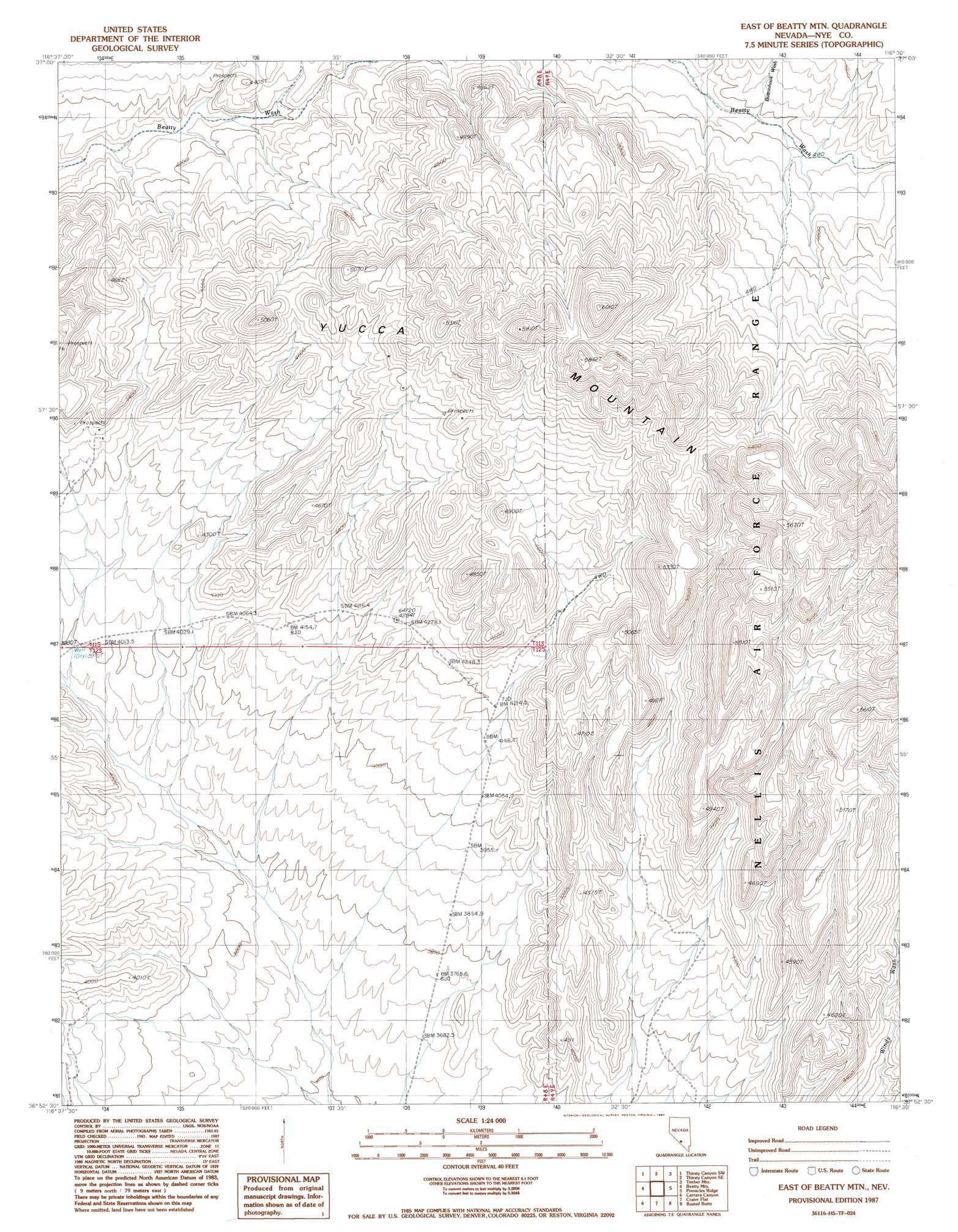
East Of Beatty Mountain Topo Map Nevada
To zoom in, hover over the map of East Of Beatty Mountain
USGS Topo Quad 36116h5 - 1:24,000 scale
| Topo Map Name: | East Of Beatty Mountain |
| USGS Topo Quad ID: | 36116h5 |
| Print Size: | ca. 21 1/4" wide x 27" high |
| Southeast Coordinates: | 36.875° N latitude / 116.5° W longitude |
| Map Center Coordinates: | 36.9375° N latitude / 116.5625° W longitude |
| U.S. State: | NV |
| Filename: | o36116h5.jpg |
| Download Map JPG Image: | East Of Beatty Mountain topo map 1:24,000 scale |
| Map Type: | Topographic |
| Topo Series: | 7.5´ |
| Map Scale: | 1:24,000 |
| Source of Map Images: | United States Geological Survey (USGS) |
| Alternate Map Versions: |
East of Beatty Mtn. NV 1987, updated 1987 Download PDF Buy paper map |
1:24,000 Topo Quads surrounding East Of Beatty Mountain
Springdale Ne |
Thirsty Canyon Nw |
Thirsty Canyon |
Scrugham Peak |
Ammonia Tanks |
Springdale |
Thirsty Canyon Sw |
Thirsty Canyon Se |
Timber Mountain |
Buckboard Mesa |
Beatty |
Beatty Mountain |
East Of Beatty Mountain |
Topopah Springs Nw |
Topopah Spring |
Gold Center |
Carrara Canyon |
Crater Flat |
Busted Butte |
Jackass Flats |
East Of Chloride City |
Ashton |
Big Dune |
Lathrop Wells |
Striped Hills |
> Back to 36116e1 at 1:100,000 scale
> Back to 36116a1 at 1:250,000 scale
> Back to U.S. Topo Maps home
East Of Beatty Mountain topo map: Gazetteer
East Of Beatty Mountain: Arroyos
Buttonhook Wash elevation 1389m 4557′East Of Beatty Mountain: Basins
Wagon Valley elevation 1501m 4924′East Of Beatty Mountain: Gaps
Prospector Pass elevation 1436m 4711′East Of Beatty Mountain: Ridges
Gaunt Ridge elevation 1407m 4616′Table Ridge elevation 1711m 5613′
East Of Beatty Mountain: Streams
Shepherd Wash elevation 1218m 3996′East Of Beatty Mountain digital topo map on disk
Buy this East Of Beatty Mountain topo map showing relief, roads, GPS coordinates and other geographical features, as a high-resolution digital map file on DVD:
Southern Sierra Nevada, California & Southern Nevada
Buy digital topo maps: Southern Sierra Nevada, California & Southern Nevada