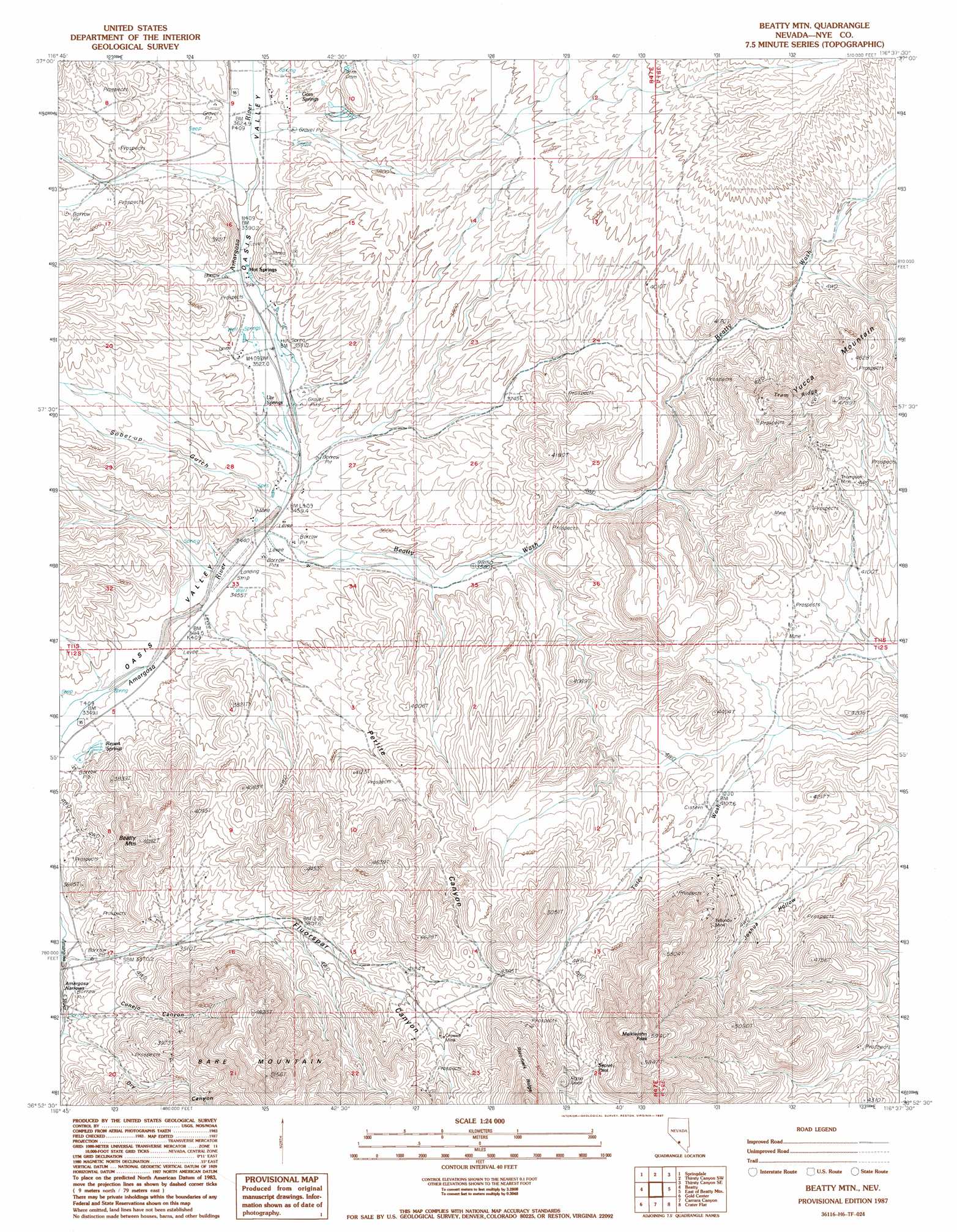
Beatty Mountain Topo Map Nevada
To zoom in, hover over the map of Beatty Mountain
USGS Topo Quad 36116h6 - 1:24,000 scale
| Topo Map Name: | Beatty Mountain |
| USGS Topo Quad ID: | 36116h6 |
| Print Size: | ca. 21 1/4" wide x 27" high |
| Southeast Coordinates: | 36.875° N latitude / 116.625° W longitude |
| Map Center Coordinates: | 36.9375° N latitude / 116.6875° W longitude |
| U.S. State: | NV |
| Filename: | o36116h6.jpg |
| Download Map JPG Image: | Beatty Mountain topo map 1:24,000 scale |
| Map Type: | Topographic |
| Topo Series: | 7.5´ |
| Map Scale: | 1:24,000 |
| Source of Map Images: | United States Geological Survey (USGS) |
| Alternate Map Versions: |
Beatty Mtn NV 1987, updated 1987 Download PDF Buy paper map |
1:24,000 Topo Quads surrounding Beatty Mountain
Springdale Nw |
Springdale Ne |
Thirsty Canyon Nw |
Thirsty Canyon |
Scrugham Peak |
Springdale Sw |
Springdale |
Thirsty Canyon Sw |
Thirsty Canyon Se |
Timber Mountain |
Bullfrog Mountain |
Beatty |
Beatty Mountain |
East Of Beatty Mountain |
Topopah Springs Nw |
Daylight Pass |
Gold Center |
Carrara Canyon |
Crater Flat |
Busted Butte |
Chloride City |
East Of Chloride City |
Ashton |
Big Dune |
Lathrop Wells |
> Back to 36116e1 at 1:100,000 scale
> Back to 36116a1 at 1:250,000 scale
> Back to U.S. Topo Maps home
Beatty Mountain topo map: Gazetteer
Beatty Mountain: Airports
Frans Star Ranch Airport elevation 1049m 3441′Beatty Mountain: Gaps
Secret Pass elevation 1501m 4924′Beatty Mountain: Mines
Crowell Mine elevation 1329m 4360′Daisy Mine elevation 1399m 4589′
Harvey Mine elevation 1158m 3799′
Silicon Mine elevation 1382m 4534′
Telluride Mine elevation 1495m 4904′
Thompson Mine elevation 1329m 4360′
Tip Top Mine elevation 1305m 4281′
Beatty Mountain: Populated Places
Fluorine (historical) elevation 1303m 4274′Hot Springs elevation 1092m 3582′
Beatty Mountain: Post Offices
Fluorine Post Office elevation 1303m 4274′Beatty Mountain: Ridges
Tram Ridge elevation 1417m 4648′Beatty Mountain: Springs
Beatty Springs elevation 1025m 3362′Burrell Hot Spring elevation 1080m 3543′
Goss Springs elevation 1121m 3677′
Hot Springs elevation 1094m 3589′
Revert Springs elevation 1032m 3385′
Ute Springs elevation 1077m 3533′
Beatty Mountain: Streams
Beatty Wash elevation 1050m 3444′Tates Wash elevation 1221m 4005′
Beatty Mountain: Summits
Beatty Mountain elevation 1309m 4294′Meiklejohn Peak elevation 1795m 5889′
Beatty Mountain: Valleys
Conejo Canyon elevation 1029m 3375′Fluorspar Canyon elevation 1038m 3405′
Joshua Hollow elevation 1215m 3986′
Perlite Canyon elevation 1084m 3556′
Sober-Up Gulch elevation 1090m 3576′
Beatty Mountain digital topo map on disk
Buy this Beatty Mountain topo map showing relief, roads, GPS coordinates and other geographical features, as a high-resolution digital map file on DVD:
Southern Sierra Nevada, California & Southern Nevada
Buy digital topo maps: Southern Sierra Nevada, California & Southern Nevada