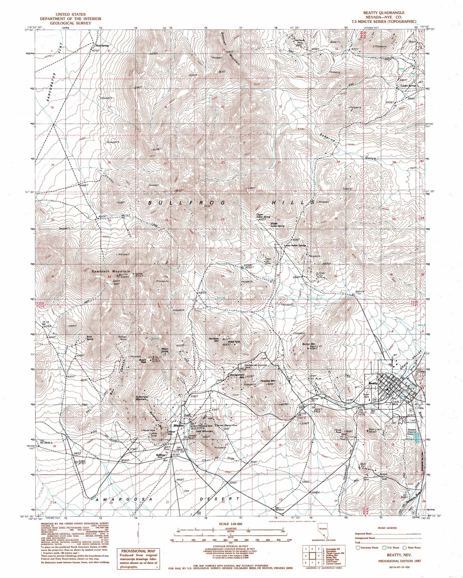
Beatty Topo Map Nevada
To zoom in, hover over the map of Beatty
USGS Topo Quad 36116h7 - 1:24,000 scale
| Topo Map Name: | Beatty |
| USGS Topo Quad ID: | 36116h7 |
| Print Size: | ca. 21 1/4" wide x 27" high |
| Southeast Coordinates: | 36.875° N latitude / 116.75° W longitude |
| Map Center Coordinates: | 36.9375° N latitude / 116.8125° W longitude |
| U.S. State: | NV |
| Filename: | o36116h7.jpg |
| Download Map JPG Image: | Beatty topo map 1:24,000 scale |
| Map Type: | Topographic |
| Topo Series: | 7.5´ |
| Map Scale: | 1:24,000 |
| Source of Map Images: | United States Geological Survey (USGS) |
| Alternate Map Versions: |
Beatty NV 1987, updated 1987 Download PDF Buy paper map Beatty NV 1987, updated 1998 Download PDF Buy paper map Beatty NV 2012 Download PDF Buy paper map Beatty NV 2014 Download PDF Buy paper map |
1:24,000 Topo Quads surrounding Beatty
Bonnie Claire |
Springdale Nw |
Springdale Ne |
Thirsty Canyon Nw |
Thirsty Canyon |
Bonnie Claire Se |
Springdale Sw |
Springdale |
Thirsty Canyon Sw |
Thirsty Canyon Se |
Wahguyhe Peak |
Bullfrog Mountain |
Beatty |
Beatty Mountain |
East Of Beatty Mountain |
Thimble Peak |
Daylight Pass |
Gold Center |
Carrara Canyon |
Crater Flat |
Stovepipe Wells |
Chloride City |
East Of Chloride City |
Ashton |
Big Dune |
> Back to 36116e1 at 1:100,000 scale
> Back to 36116a1 at 1:250,000 scale
> Back to U.S. Topo Maps home
Beatty topo map: Gazetteer
Beatty: Gaps
Amargosa Narrows elevation 974m 3195′Doris Montgomery Pass elevation 1230m 4035′
Beatty: Mines
Denver Mine elevation 1195m 3920′Gibraltar Mine elevation 1208m 3963′
King Mine elevation 1138m 3733′
Lucky Jack Mine elevation 1198m 3930′
Mayflower Mine elevation 1342m 4402′
Montgomery-Shoshone Mine elevation 1221m 4005′
National Bank Mine elevation 1124m 3687′
Senator Stewart Mine elevation 1205m 3953′
Shoshone Polaris Mine elevation 1223m 4012′
Tramps Mine elevation 1203m 3946′
Vanderbilt Mine elevation 1057m 3467′
Beatty: Populated Places
Beatty elevation 1008m 3307′Bullfrog (historical) elevation 1085m 3559′
Rhyolite elevation 1164m 3818′
Beatty: Post Offices
Beatty Post Office elevation 1009m 3310′Bullfrog Post Office (historical) elevation 1085m 3559′
Rhyolite Post Office (historical) elevation 1164m 3818′
Beatty: Ranges
Bullfrog Hills elevation 1615m 5298′Beatty: Springs
Buck Spring elevation 1377m 4517′Crystal Springs elevation 1179m 3868′
Lower Indian Springs elevation 1232m 4041′
Mason Spring elevation 1322m 4337′
Middle Indian Spring elevation 1269m 4163′
Mud Springs elevation 1289m 4229′
Sullivan Spring elevation 1396m 4580′
Upper Indian Spring elevation 1289m 4229′
Beatty: Summits
Black Peak elevation 1393m 4570′Bonanza Mountain elevation 1247m 4091′
Burton Mountain elevation 1292m 4238′
Busch Peak elevation 1511m 4957′
Ladd Mountain elevation 1246m 4087′
Montgomery Mountain elevation 1268m 4160′
Paradise Mountain elevation 1275m 4183′
Rainbow Mountain elevation 1395m 4576′
Sawtooth Mountain elevation 1746m 5728′
Sutherland Mountain elevation 1420m 4658′
Velvet Peak elevation 1183m 3881′
Beatty: Valleys
Box Canyon elevation 1078m 3536′Dry Canyon elevation 975m 3198′
Oasis Valley elevation 1026m 3366′
Beatty digital topo map on disk
Buy this Beatty topo map showing relief, roads, GPS coordinates and other geographical features, as a high-resolution digital map file on DVD:
Southern Sierra Nevada, California & Southern Nevada
Buy digital topo maps: Southern Sierra Nevada, California & Southern Nevada