Cactus Peak Topo Map California
To zoom in, hover over the map of Cactus Peak
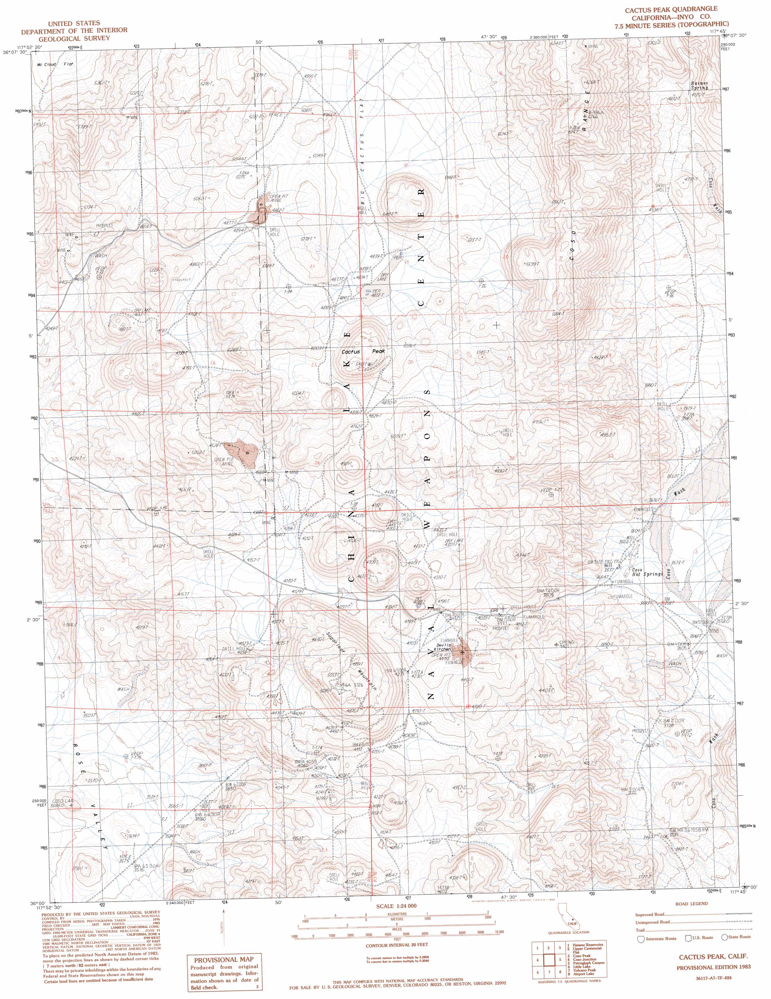
USGS Topo Quad 36117a7 - 1:24,000 scale
| Topo Map Name: | Cactus Peak |
| USGS Topo Quad ID: | 36117a7 |
| Print Size: | ca. 21 1/4" wide x 27" high |
| Southeast Coordinates: | 36° N latitude / 117.75° W longitude |
| Map Center Coordinates: | 36.0625° N latitude / 117.8125° W longitude |
| U.S. State: | CA |
| Filename: | o36117a7.jpg |
| Download Map JPG Image: | Cactus Peak topo map 1:24,000 scale |
| Map Type: | Topographic |
| Topo Series: | 7.5´ |
| Map Scale: | 1:24,000 |
| Source of Map Images: | United States Geological Survey (USGS) |
| Alternate Map Versions: |
Cactus Peak CA 1983, updated 1983 Download PDF Buy paper map Cactus Peak CA 2012 Download PDF Buy paper map Cactus Peak CA 2015 Download PDF Buy paper map |
1:24,000 Topo Quads surrounding Cactus Peak
Olancha |
Vermillion Canyon |
Centennial Canyon |
Talc City Hills |
Darwin |
Haiwee Pass |
Haiwee Reservoirs |
Upper Centennial Flat |
Coso Peak |
China Gardens |
Long Canyon |
Coso Junction |
Cactus Peak |
Petroglyph Canyon |
Louisiana Butte |
Sacatar Canyon |
Little Lake |
Volcano Peak |
Airport Lake |
Mountain Springs Canyon |
Lamont Peak |
Ninemile Canyon |
Pearsonville |
White Hills |
Burro Canyon |
> Back to 36117a1 at 1:100,000 scale
> Back to 36116a1 at 1:250,000 scale
> Back to U.S. Topo Maps home
Cactus Peak topo map: Gazetteer
Cactus Peak: Flats
Devils Kitchen elevation 1264m 4146′Upper Cactus Flat elevation 1519m 4983′
Cactus Peak: Springs
Coso Hot Springs elevation 1105m 3625′Haiwee Spring elevation 1446m 4744′
Cactus Peak: Summits
Cactus Peak elevation 1640m 5380′Sugarloaf Mountain elevation 1547m 5075′
Cactus Peak digital topo map on disk
Buy this Cactus Peak topo map showing relief, roads, GPS coordinates and other geographical features, as a high-resolution digital map file on DVD:
Southern Sierra Nevada, California & Southern Nevada
Buy digital topo maps: Southern Sierra Nevada, California & Southern Nevada