Dolomite Topo Map California
To zoom in, hover over the map of Dolomite
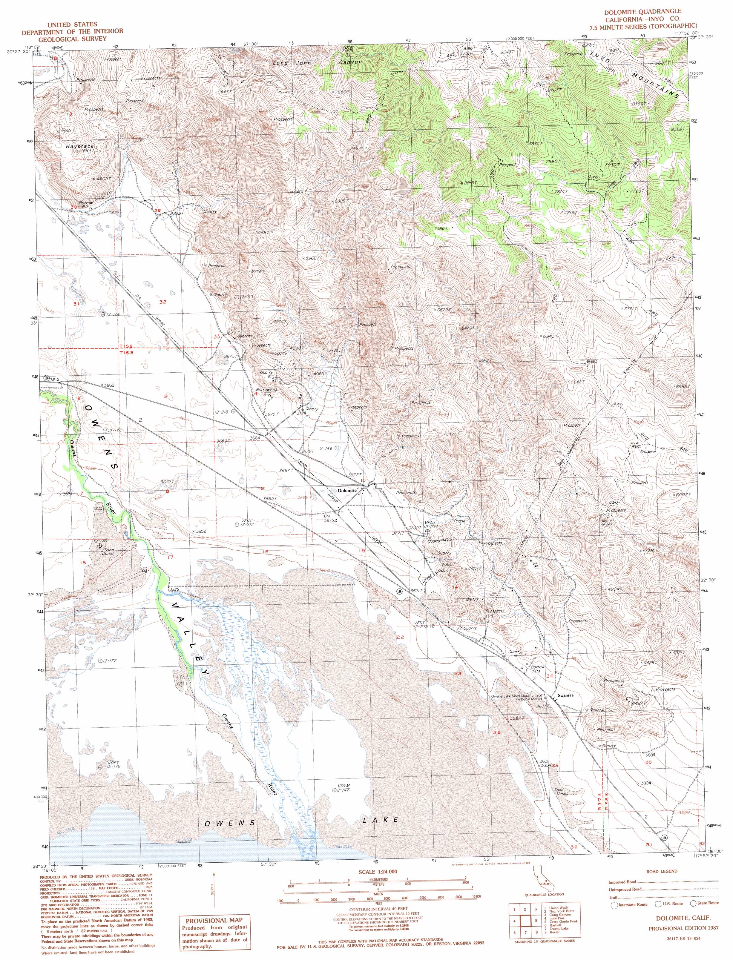
USGS Topo Quad 36117e8 - 1:24,000 scale
| Topo Map Name: | Dolomite |
| USGS Topo Quad ID: | 36117e8 |
| Print Size: | ca. 21 1/4" wide x 27" high |
| Southeast Coordinates: | 36.5° N latitude / 117.875° W longitude |
| Map Center Coordinates: | 36.5625° N latitude / 117.9375° W longitude |
| U.S. State: | CA |
| Filename: | o36117e8.jpg |
| Download Map JPG Image: | Dolomite topo map 1:24,000 scale |
| Map Type: | Topographic |
| Topo Series: | 7.5´ |
| Map Scale: | 1:24,000 |
| Source of Map Images: | United States Geological Survey (USGS) |
| Alternate Map Versions: |
Dolomite CA 1987 Download PDF Buy paper map Dolomite CA 1987, updated 1987 Download PDF Buy paper map Dolomite CA 1987, updated 1987 Download PDF Buy paper map Dolomite CA 2012 Download PDF Buy paper map Dolomite CA 2015 Download PDF Buy paper map |
1:24,000 Topo Quads surrounding Dolomite
Independence |
Bee Springs Canyon |
Pat Keyes Canyon |
Lower Warm Springs |
West Of Teakettle Junction |
Manzanar |
Union Wash |
New York Butte |
Craig Canyon |
West Of Ubehebe Peak |
Mount Langley |
Lone Pine |
Dolomite |
Cerro Gordo Peak |
Nelson Range |
Cirque Peak |
Bartlett |
Owens Lake |
Keeler |
Santa Rosa Flat |
Templeton Mountain |
Olancha |
Vermillion Canyon |
Centennial Canyon |
Talc City Hills |
> Back to 36117e1 at 1:100,000 scale
> Back to 36116a1 at 1:250,000 scale
> Back to U.S. Topo Maps home
Dolomite topo map: Gazetteer
Dolomite: Parks
Owens Lake-Silver Lead Furnace Historical Marker elevation 1110m 3641′Dolomite: Populated Places
Alico elevation 1119m 3671′Dolomite elevation 1120m 3674′
Mock elevation 1110m 3641′
Swansea elevation 1116m 3661′
Dolomite: Streams
Owens River elevation 1095m 3592′Dolomite: Summits
Haystack elevation 1412m 4632′Dolomite: Wells
Burgess Well elevation 2788m 9146′Dolomite digital topo map on disk
Buy this Dolomite topo map showing relief, roads, GPS coordinates and other geographical features, as a high-resolution digital map file on DVD:
Southern Sierra Nevada, California & Southern Nevada
Buy digital topo maps: Southern Sierra Nevada, California & Southern Nevada