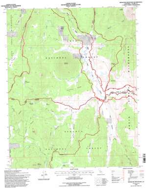
Monache Mountain Topo Map California
To zoom in, hover over the map of Monache Mountain
USGS Topo Quad 36118b2 - 1:24,000 scale
| Topo Map Name: | Monache Mountain |
| USGS Topo Quad ID: | 36118b2 |
| Print Size: | ca. 21 1/4" wide x 27" high |
| Southeast Coordinates: | 36.125° N latitude / 118.125° W longitude |
| Map Center Coordinates: | 36.1875° N latitude / 118.1875° W longitude |
| U.S. State: | CA |
| Filename: | o36118b2.jpg |
| Download Map JPG Image: | Monache Mountain topo map 1:24,000 scale |
| Map Type: | Topographic |
| Topo Series: | 7.5´ |
| Map Scale: | 1:24,000 |
| Source of Map Images: | United States Geological Survey (USGS) |
| Alternate Map Versions: |
Monache Mountain CA 1987, updated 1987 Download PDF Buy paper map Monache Mountain CA 1987, updated 1994 Download PDF Buy paper map Monache Mountain CA 1994, updated 1997 Download PDF Buy paper map Monache Mountain CA 2012 Download PDF Buy paper map Monache Mountain CA 2015 Download PDF Buy paper map |
| FStopo: | US Forest Service topo Monache Mountain is available: Download FStopo PDF Download FStopo TIF |
1:24,000 Topo Quads surrounding Monache Mountain
> Back to 36118a1 at 1:100,000 scale
> Back to 36118a1 at 1:250,000 scale
> Back to U.S. Topo Maps home
Monache Mountain topo map: Gazetteer
Monache Mountain: Capes
Anderson Point elevation 2560m 8398′Monache Mountain: Flats
Albanita Meadows elevation 2634m 8641′Bakeoven Meadow elevation 2443m 8015′
Beck Meadow elevation 2396m 7860′
Big Dry Meadow elevation 2652m 8700′
Broder Meadow elevation 2408m 7900′
Bull Meadow elevation 2452m 8044′
Hessian Meadow elevation 2462m 8077′
Hooker Meadow elevation 2634m 8641′
Little Dry Meadow elevation 2645m 8677′
Lost Meadow elevation 2556m 8385′
McConnell Meadow elevation 2515m 8251′
Monache Meadow elevation 2401m 7877′
Powell Meadow elevation 2489m 8166′
Silas Reynolds Meadow elevation 2545m 8349′
Smith Meadows elevation 2469m 8100′
Monache Mountain: Islands
Deer Island elevation 2495m 8185′Monache Mountain: Ridges
Kingfisher Ridge elevation 2842m 9324′Summers Ridge elevation 2428m 7965′
Monache Mountain: Springs
Aqua Bonita Spring elevation 2634m 8641′Olivas Spring elevation 2448m 8031′
Soda Springs elevation 2402m 7880′
Monache Mountain: Streams
Kingfisher Stringer elevation 2464m 8083′Monache Creek elevation 2399m 7870′
Round Mountain Stringer elevation 2400m 7874′
Snake Creek elevation 2397m 7864′
Soda Creek elevation 2401m 7877′
Monache Mountain: Summits
Granite Knob elevation 2707m 8881′Jackass Peak elevation 2759m 9051′
Monache Mountain elevation 2855m 9366′
Smith Mountain elevation 2872m 9422′
Monache Mountain: Valleys
Cow Canyon elevation 2404m 7887′Monache Mountain digital topo map on disk
Buy this Monache Mountain topo map showing relief, roads, GPS coordinates and other geographical features, as a high-resolution digital map file on DVD:
Southern Sierra Nevada, California & Southern Nevada
Buy digital topo maps: Southern Sierra Nevada, California & Southern Nevada


