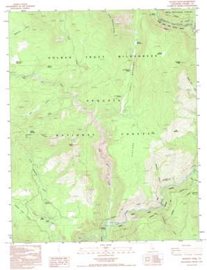
Hockett Peak Topo Map California
To zoom in, hover over the map of Hockett Peak
USGS Topo Quad 36118b4 - 1:24,000 scale
| Topo Map Name: | Hockett Peak |
| USGS Topo Quad ID: | 36118b4 |
| Print Size: | ca. 21 1/4" wide x 27" high |
| Southeast Coordinates: | 36.125° N latitude / 118.375° W longitude |
| Map Center Coordinates: | 36.1875° N latitude / 118.4375° W longitude |
| U.S. State: | CA |
| Filename: | o36118b4.jpg |
| Download Map JPG Image: | Hockett Peak topo map 1:24,000 scale |
| Map Type: | Topographic |
| Topo Series: | 7.5´ |
| Map Scale: | 1:24,000 |
| Source of Map Images: | United States Geological Survey (USGS) |
| Alternate Map Versions: |
Hockett Peak CA 1987, updated 1987 Download PDF Buy paper map Hockett Peak CA 1993, updated 1995 Download PDF Buy paper map Hockett Peak CA 2012 Download PDF Buy paper map Hockett Peak CA 2015 Download PDF Buy paper map |
| FStopo: | US Forest Service topo Hockett Peak is available: Download FStopo PDF Download FStopo TIF |
1:24,000 Topo Quads surrounding Hockett Peak
> Back to 36118a1 at 1:100,000 scale
> Back to 36118a1 at 1:250,000 scale
> Back to U.S. Topo Maps home
Hockett Peak topo map: Gazetteer
Hockett Peak: Areas
Forks of the Kern elevation 1427m 4681′The Hazards elevation 1842m 6043′
Hockett Peak: Basins
Hells Hole elevation 1827m 5994′Hockett Peak: Flats
Burnt Corral Meadows elevation 1879m 6164′Doe Meadow elevation 1897m 6223′
Flatiron elevation 1943m 6374′
Hockett Meadows elevation 2313m 7588′
Jerkey Meadow elevation 2098m 6883′
Lloyd Meadows elevation 1703m 5587′
Round Meadow elevation 1886m 6187′
Sacratone Flat elevation 1703m 5587′
Trout Meadows elevation 1905m 6250′
Willow Meadows elevation 1945m 6381′
Hockett Peak: Gaps
Hole-in-the Ground elevation 1735m 5692′Hockett Peak: Springs
Cold Spring elevation 1978m 6489′Jug Spring elevation 1888m 6194′
Soda Spring elevation 1688m 5538′
Trout Meadows Spring elevation 1908m 6259′
Hockett Peak: Streams
Deep Creek elevation 1793m 5882′Fish Creek elevation 1770m 5807′
Hells Hole Creek elevation 1671m 5482′
Little Kern River elevation 1460m 4790′
Lloyd Meadows Creek elevation 1692m 5551′
Osa Creek elevation 1538m 5045′
Rattlesnake Creek elevation 1464m 4803′
Soda Creek elevation 1520m 4986′
Hockett Peak: Summits
Castle Rock elevation 2276m 7467′Hockett Peak elevation 2487m 8159′
Hockett Peak: Valleys
Deadman Canyon elevation 1598m 5242′Hockett Peak digital topo map on disk
Buy this Hockett Peak topo map showing relief, roads, GPS coordinates and other geographical features, as a high-resolution digital map file on DVD:
Southern Sierra Nevada, California & Southern Nevada
Buy digital topo maps: Southern Sierra Nevada, California & Southern Nevada


