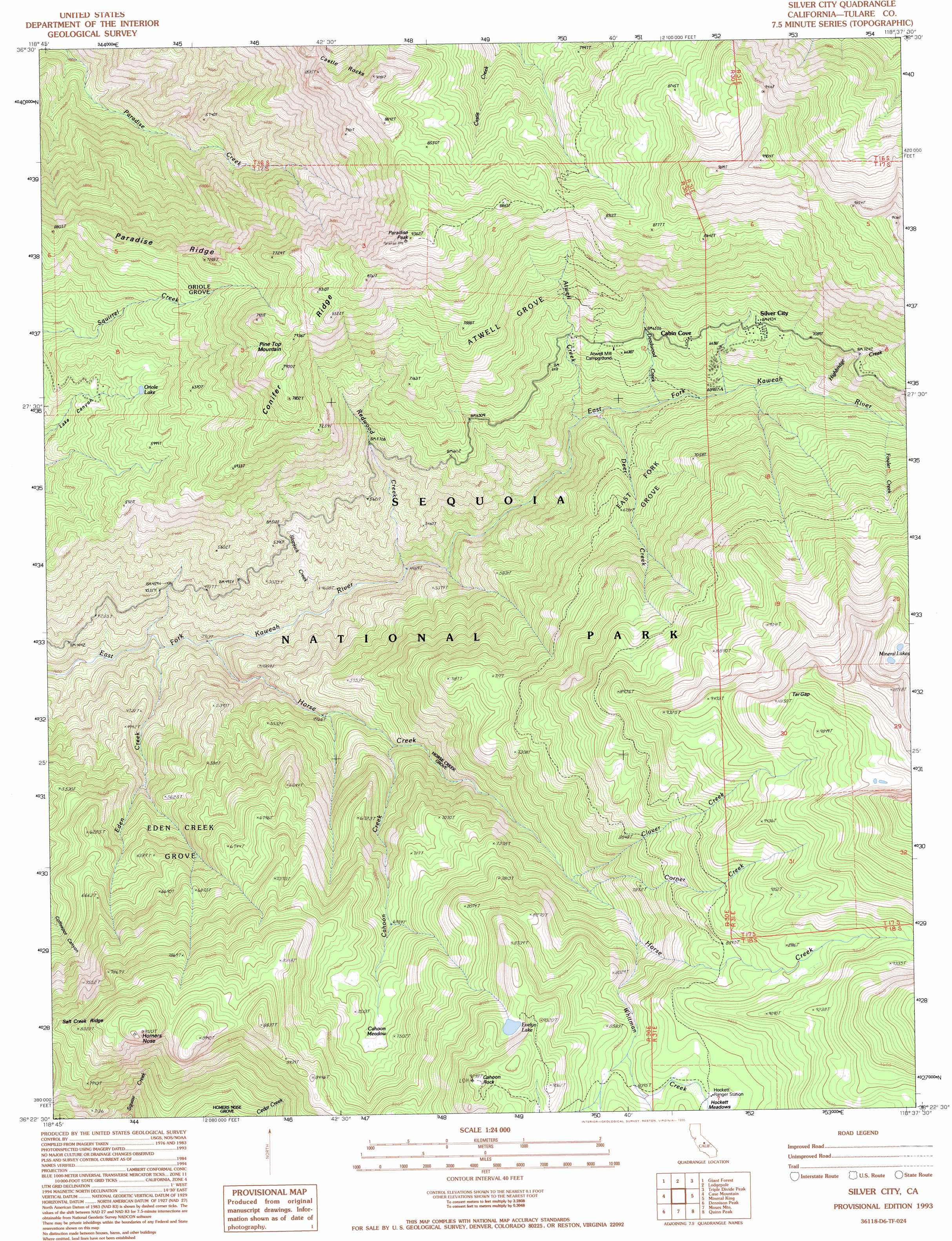
Silver City Topo Map California
To zoom in, hover over the map of Silver City
USGS Topo Quad 36118d6 - 1:24,000 scale
| Topo Map Name: | Silver City |
| USGS Topo Quad ID: | 36118d6 |
| Print Size: | ca. 21 1/4" wide x 27" high |
| Southeast Coordinates: | 36.375° N latitude / 118.625° W longitude |
| Map Center Coordinates: | 36.4375° N latitude / 118.6875° W longitude |
| U.S. State: | CA |
| Filename: | o36118d6.jpg |
| Download Map JPG Image: | Silver City topo map 1:24,000 scale |
| Map Type: | Topographic |
| Topo Series: | 7.5´ |
| Map Scale: | 1:24,000 |
| Source of Map Images: | United States Geological Survey (USGS) |
| Alternate Map Versions: |
Silver City CA 1988, updated 1988 Download PDF Buy paper map Silver City CA 1993, updated 1995 Download PDF Buy paper map Silver City CA 2012 Download PDF Buy paper map Silver City CA 2015 Download PDF Buy paper map |
| FStopo: | US Forest Service topo Silver City is available: Download FStopo PDF Download FStopo TIF |
1:24,000 Topo Quads surrounding Silver City
General Grant Grove |
Muir Grove |
Mount Stillman |
Sphinx Lakes |
Mount Brewer |
Shadequarter Mountain |
Giant Forest |
Lodgepole |
Triple Divide Peak |
Mount Kaweah |
Kaweah |
Case Mountain |
Silver City |
Mineral King |
Chagoopa Falls |
Chickencoop Canyon |
Dennison Peak |
Moses Mountain |
Quinn Peak |
Kern Lake |
Frazier Valley |
Springville |
Camp Wishon |
Camp Nelson |
Hockett Peak |
> Back to 36118a1 at 1:100,000 scale
> Back to 36118a1 at 1:250,000 scale
> Back to U.S. Topo Maps home
Silver City topo map: Gazetteer
Silver City: Flats
Cahoon Meadow elevation 2241m 7352′Hockett Meadows elevation 2591m 8500′
Silver City: Gaps
Tar Gap elevation 3050m 10006′Silver City: Lakes
Evelyn Lake elevation 2655m 8710′Oriole Lake elevation 1719m 5639′
Silver City: Populated Places
Cabin Cove elevation 2057m 6748′Silver City elevation 2115m 6938′
Silver City: Ridges
Conifer Ridge elevation 2654m 8707′Paradise Ridge elevation 2854m 9363′
Salt Creek Ridge elevation 2734m 8969′
Silver City: Streams
Atwell Creek elevation 1702m 5583′Cahoon Creek elevation 1643m 5390′
Clover Creek elevation 2109m 6919′
Corner Creek elevation 2730m 8956′
Deadwood Creek elevation 1755m 5757′
Deer Creek elevation 1692m 5551′
Eden Creek elevation 1161m 3809′
Fowler Creek elevation 2068m 6784′
Highbridge Creek elevation 1959m 6427′
Horse Creek elevation 1227m 4025′
Redwood Creek elevation 1375m 4511′
Slapjack Creek elevation 1280m 4199′
Whitman Creek elevation 2299m 7542′
Silver City: Summits
Cahoon Rock elevation 2798m 9179′Castle Rocks elevation 2768m 9081′
Homers Nose elevation 2734m 8969′
Paradise Peak elevation 2854m 9363′
Pine Top Mountain elevation 2418m 7933′
Silver City: Trails
Atwell Hockett Trail elevation 2150m 7053′Hockett Meadow Trail elevation 2498m 8195′
Silver City: Woods
Atwell Grove elevation 2102m 6896′East Fork Grove elevation 2047m 6715′
Eden Creek Grove elevation 1719m 5639′
Homers Nose Grove elevation 2326m 7631′
Horse Creek Grove elevation 1844m 6049′
Oriole Grove elevation 2028m 6653′
Silver City digital topo map on disk
Buy this Silver City topo map showing relief, roads, GPS coordinates and other geographical features, as a high-resolution digital map file on DVD:
Southern Sierra Nevada, California & Southern Nevada
Buy digital topo maps: Southern Sierra Nevada, California & Southern Nevada