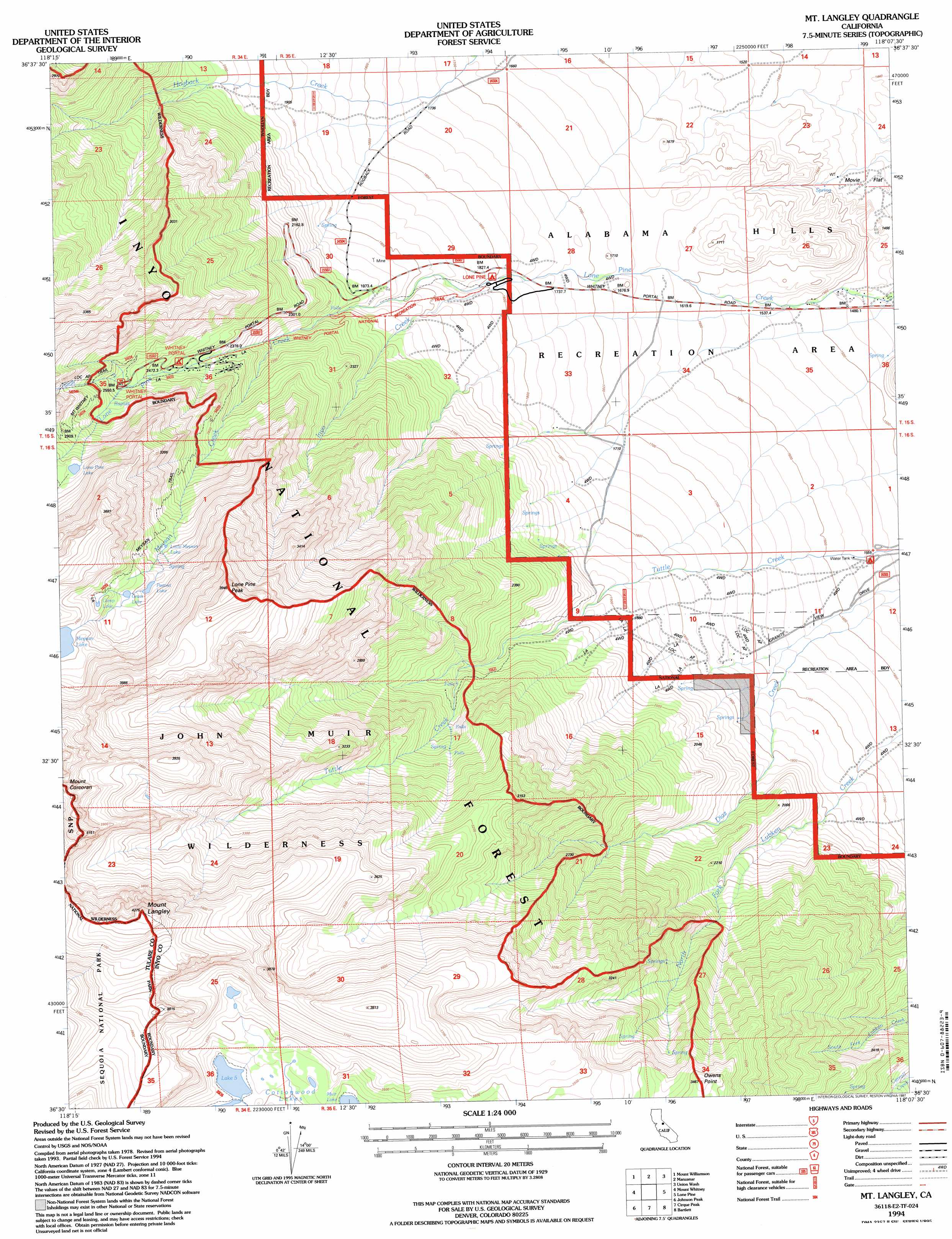
Mount Langley Topo Map California
To zoom in, hover over the map of Mount Langley
USGS Topo Quad 36118e2 - 1:24,000 scale
| Topo Map Name: | Mount Langley |
| USGS Topo Quad ID: | 36118e2 |
| Print Size: | ca. 21 1/4" wide x 27" high |
| Southeast Coordinates: | 36.5° N latitude / 118.125° W longitude |
| Map Center Coordinates: | 36.5625° N latitude / 118.1875° W longitude |
| U.S. State: | CA |
| Filename: | o36118e2.jpg |
| Download Map JPG Image: | Mount Langley topo map 1:24,000 scale |
| Map Type: | Topographic |
| Topo Series: | 7.5´ |
| Map Scale: | 1:24,000 |
| Source of Map Images: | United States Geological Survey (USGS) |
| Alternate Map Versions: |
Mt. Langley CA 1982, updated 1983 Download PDF Buy paper map Mt. Langley CA 1993, updated 1994 Download PDF Buy paper map Mt. Langley CA 1994, updated 1997 Download PDF Buy paper map Mount Langley CA 2012 Download PDF Buy paper map Mount Langley CA 2015 Download PDF Buy paper map |
| FStopo: | US Forest Service topo Mount Langley is available: Download FStopo PDF Download FStopo TIF |
1:24,000 Topo Quads surrounding Mount Langley
Mount Clarence King |
Kearsarge Peak |
Independence |
Bee Springs Canyon |
Pat Keyes Canyon |
Mount Brewer |
Mount Williamson |
Manzanar |
Union Wash |
New York Butte |
Mount Kaweah |
Mount Whitney |
Mount Langley |
Lone Pine |
Dolomite |
Chagoopa Falls |
Johnson Peak |
Cirque Peak |
Bartlett |
Owens Lake |
Kern Lake |
Kern Peak |
Templeton Mountain |
Olancha |
Vermillion Canyon |
> Back to 36118e1 at 1:100,000 scale
> Back to 36118a1 at 1:250,000 scale
> Back to U.S. Topo Maps home
Mount Langley topo map: Gazetteer
Mount Langley: Flats
Big Cottonwood Meadows elevation 3425m 11236′Mount Langley: Gaps
Whitney Portal elevation 2399m 7870′Mount Langley: Lakes
Camp Lake elevation 3399m 11151′Cottonwood Lake Number Five elevation 3413m 11197′
Cottonwood Lake Number Six elevation 3535m 11597′
Grass Lake elevation 3315m 10875′
Little Meysan Lake elevation 3123m 10246′
Lone Pine Lake elevation 3040m 9973′
Muir Lake elevation 3392m 11128′
Peanut Lake elevation 3253m 10672′
Mount Langley: Parks
Alabama Hills Recreation Area elevation 1656m 5433′Mount Langley: Populated Places
Whitney Portal elevation 2393m 7851′Mount Langley: Streams
Inyo Creek elevation 1749m 5738′Meysan Creek elevation 2194m 7198′
North Fork Lone Pine Creek elevation 2560m 8398′
Mount Langley: Summits
Lone Pine Peak elevation 3914m 12841′Mount Langley elevation 4261m 13979′
Owens Point elevation 3446m 11305′
Mount Langley: Trails
Meysan Trail elevation 2762m 9061′Mount Langley digital topo map on disk
Buy this Mount Langley topo map showing relief, roads, GPS coordinates and other geographical features, as a high-resolution digital map file on DVD:
Southern Sierra Nevada, California & Southern Nevada
Buy digital topo maps: Southern Sierra Nevada, California & Southern Nevada