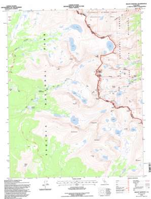
Mount Whitney Topo Map California
To zoom in, hover over the map of Mount Whitney
USGS Topo Quad 36118e3 - 1:24,000 scale
| Topo Map Name: | Mount Whitney |
| USGS Topo Quad ID: | 36118e3 |
| Print Size: | ca. 21 1/4" wide x 27" high |
| Southeast Coordinates: | 36.5° N latitude / 118.25° W longitude |
| Map Center Coordinates: | 36.5625° N latitude / 118.3125° W longitude |
| U.S. State: | CA |
| Filename: | o36118e3.jpg |
| Download Map JPG Image: | Mount Whitney topo map 1:24,000 scale |
| Map Type: | Topographic |
| Topo Series: | 7.5´ |
| Map Scale: | 1:24,000 |
| Source of Map Images: | United States Geological Survey (USGS) |
| Alternate Map Versions: |
Mount Whitney CA 1985, updated 1985 Download PDF Buy paper map Mount Whitney CA 1993, updated 1994 Download PDF Buy paper map Mount Whitney CA 1993, updated 1994 Download PDF Buy paper map Mount Whitney CA 1994, updated 1997 Download PDF Buy paper map Mount Whitney CA 2012 Download PDF Buy paper map Mount Whitney CA 2015 Download PDF Buy paper map |
| FStopo: | US Forest Service topo Mount Whitney is available: Download FStopo PDF Download FStopo TIF |
1:24,000 Topo Quads surrounding Mount Whitney
> Back to 36118e1 at 1:100,000 scale
> Back to 36118a1 at 1:250,000 scale
> Back to U.S. Topo Maps home
Mount Whitney topo map: Gazetteer
Mount Whitney: Flats
Bighorn Park elevation 3160m 10367′Clyde Meadow elevation 3396m 11141′
Crabtree Meadow elevation 3152m 10341′
Guyot Flat elevation 3232m 10603′
Sandy Meadow elevation 3204m 10511′
Mount Whitney: Gaps
Arc Pass elevation 3904m 12808′Crabtree Pass elevation 3839m 12595′
Sheep Pass (historical) elevation 3784m 12414′
Trail Crest elevation 4159m 13645′
Vacation Pass elevation 3913m 12837′
Whitney Pass elevation 4063m 13330′
Mount Whitney: Lakes
Arctic Lake elevation 3732m 12244′Consultation Lake elevation 3562m 11686′
Crabtree Lakes elevation 3458m 11345′
Erin Lake elevation 3556m 11666′
Frog Pond elevation 3537m 11604′
Guitar Lake elevation 3495m 11466′
Hitchcock Lakes elevation 3542m 11620′
Iridescent Lake elevation 3631m 11912′
Lower Boy Scout Lake elevation 3154m 10347′
Meysan Lake elevation 3489m 11446′
Mirror Lake elevation 3253m 10672′
Primrose Lake elevation 3553m 11656′
Sky Blue Lake elevation 3521m 11551′
Timberline Lake elevation 3374m 11069′
Tulainyo Lake elevation 3910m 12828′
Upper Boy Scout Lake elevation 3456m 11338′
Wales Lake elevation 3576m 11732′
Wallace Lake elevation 3499m 11479′
Mount Whitney: Pillars
Keeler Needle elevation 4277m 14032′The Major General elevation 3754m 12316′
Mount Whitney: Ranges
Sierra Nevada elevation 4400m 14435′Mount Whitney: Ridges
Pinnacle Ridge elevation 3904m 12808′Mount Whitney: Streams
Crabtree Creek elevation 3151m 10337′Mount Whitney: Summits
Crooks Peak elevation 4328m 14199′Discovery Pinnacle elevation 4119m 13513′
Joe Devel Peak elevation 4030m 13221′
Mount Carillon elevation 4119m 13513′
Mount Chamberlin elevation 4011m 13159′
Mount Corcoran elevation 4140m 13582′
Mount Guyot elevation 3744m 12283′
Mount Hale elevation 4109m 13480′
Mount Hitchcock elevation 3971m 13028′
Mount Irvine elevation 4197m 13769′
Mount Le Conte elevation 4198m 13772′
Mount Mallory elevation 4148m 13608′
Mount Marsh elevation 4118m 13510′
Mount McAdie elevation 4090m 13418′
Mount Muir elevation 4262m 13982′
Mount Newcomb elevation 4090m 13418′
Mount Pickering elevation 4105m 13467′
Mount Russell elevation 4281m 14045′
Mount Whitney elevation 4405m 14452′
Mount Young elevation 4010m 13156′
The Miter elevation 3847m 12621′
Thor Peak elevation 3727m 12227′
Tunnabora Peak elevation 4120m 13517′
Wotans Throne elevation 3876m 12716′
Mount Whitney: Trails
Mount Whitney Trail elevation 3490m 11450′Mount Whitney digital topo map on disk
Buy this Mount Whitney topo map showing relief, roads, GPS coordinates and other geographical features, as a high-resolution digital map file on DVD:
Southern Sierra Nevada, California & Southern Nevada
Buy digital topo maps: Southern Sierra Nevada, California & Southern Nevada


