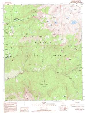
Lodgepole Topo Map California
To zoom in, hover over the map of Lodgepole
USGS Topo Quad 36118e6 - 1:24,000 scale
| Topo Map Name: | Lodgepole |
| USGS Topo Quad ID: | 36118e6 |
| Print Size: | ca. 21 1/4" wide x 27" high |
| Southeast Coordinates: | 36.5° N latitude / 118.625° W longitude |
| Map Center Coordinates: | 36.5625° N latitude / 118.6875° W longitude |
| U.S. State: | CA |
| Filename: | o36118e6.jpg |
| Download Map JPG Image: | Lodgepole topo map 1:24,000 scale |
| Map Type: | Topographic |
| Topo Series: | 7.5´ |
| Map Scale: | 1:24,000 |
| Source of Map Images: | United States Geological Survey (USGS) |
| Alternate Map Versions: |
Lodgepole CA 1988, updated 1988 Download PDF Buy paper map Lodgepole CA 1993, updated 1995 Download PDF Buy paper map Lodgepole CA 2012 Download PDF Buy paper map Lodgepole CA 2015 Download PDF Buy paper map |
1:24,000 Topo Quads surrounding Lodgepole
> Back to 36118e1 at 1:100,000 scale
> Back to 36118a1 at 1:250,000 scale
> Back to U.S. Topo Maps home
Lodgepole topo map: Gazetteer
Lodgepole: Falls
Tokopah Falls elevation 2516m 8254′Lodgepole: Flats
Alta Meadow elevation 2749m 9019′Crescent Meadow elevation 2048m 6719′
Little Bearpaw Meadow elevation 2091m 6860′
Little Sand Meadow elevation 2492m 8175′
Log Meadow elevation 2066m 6778′
Long Meadow elevation 2254m 7395′
Mehrten Meadow elevation 2746m 9009′
Panther Meadow elevation 2501m 8205′
Red Fir Meadow elevation 2537m 8323′
Redwood Meadow elevation 1849m 6066′
Table Meadows elevation 3110m 10203′
Tokopah Valley elevation 2119m 6952′
Willow Meadow elevation 2214m 7263′
Lodgepole: Gaps
Panther Gap elevation 2586m 8484′Lodgepole: Lakes
Aster Lake elevation 2775m 9104′Emerald Lake elevation 2814m 9232′
Heather Lake elevation 2826m 9271′
Moose Lake elevation 3214m 10544′
Pear Lake elevation 2909m 9543′
Lodgepole: Pillars
Tharps Rock elevation 3261m 10698′Lodgepole: Ridges
Sevenmile Hill elevation 2092m 6863′Lodgepole: Streams
Buck Creek elevation 1386m 4547′Castle Creek elevation 1280m 4199′
Cliff Creek elevation 1476m 4842′
Clover Creek elevation 1962m 6437′
Dome Creek elevation 1080m 3543′
Eagle Scout Creek elevation 1762m 5780′
Granite Creek elevation 1645m 5396′
Horse Creek elevation 2183m 7162′
Horse Creek elevation 2702m 8864′
Mehrten Creek elevation 1264m 4146′
Moro Creek elevation 937m 3074′
Panther Creek elevation 1132m 3713′
Silliman Creek elevation 2009m 6591′
Lodgepole: Summits
Alta Peak elevation 3437m 11276′Congress Group elevation 2252m 7388′
Little Blue Dome elevation 2175m 7135′
Panoramic View (historical) elevation 2650m 8694′
Panther Peak elevation 2758m 9048′
Sugarbowl Dome elevation 2334m 7657′
Lodgepole: Trails
High Sierra Trail elevation 2329m 7641′Lodgepole: Valleys
Buck Canyon elevation 1398m 4586′River Valley elevation 1857m 6092′
Lodgepole: Woods
Castle Creek Grove elevation 1606m 5269′Redwood Meadow Grove elevation 1695m 5561′
Lodgepole digital topo map on disk
Buy this Lodgepole topo map showing relief, roads, GPS coordinates and other geographical features, as a high-resolution digital map file on DVD:
Southern Sierra Nevada, California & Southern Nevada
Buy digital topo maps: Southern Sierra Nevada, California & Southern Nevada


